
Beginning May 24 and through May 30, the University of Southern Mississippi (USM) and The Nature Conservancy will be conducting joint field operations to collect high resolution imagery in and around the waters of Buck Island Reef National Monument, St. Croix.
Data will be collected using small Unmanned Aircraft Systems (UAS), commonly referred to as drones. The collected data will contribute to several research projects. It will be used to generate 2D seafloor mosaics and 3D bathymetry or underwater topography maps in shallow-water (<5m) environments.
These maps will be used to identify and inventory individual coral colonies within the reefs of these waters. The project team will be on site coordinating all boat and Unmanned Aircraft Systems operations. These activities will be conducted only during daylight hours within a safe and legally required distance (line-of-sight) of the UAS pilot. The Unmanned Aircraft Systems (UAS) will be launched and recovered from the island.
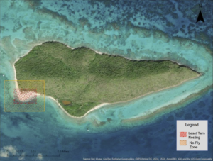
The project team will avoid all UAS operations on West Beach due to the potential of interfering with nesting least terns and their habitat in those areas (see attached map). Except for the areas identified in this map, the UAS operations will be conducted throughout the shallow water area of the National Monument. Once airborne, the UAS will operate exclusively between 200 and 400 feet above the water surface presenting no danger to boating, snorkeling or other activities on the land or waters within park boundaries.
Aside from take-off and landing, the UAS when in operation is very quiet and should not be noticeable to others involved in recreational activities. The take-off and landing sites will be selected to be as far from sensitive sites and park visitors as practically possible.
These operations will be conducted during the early morning hours (6 a.m. to 9:30 a.m.), prior to the arrival of most park concession vessels and/or in the late afternoon (3 p.m. to 6:30 p.m.) after prime visitation hours are over, to avoid conflicts with visitor recreational activities. This mission complies with Department of Interior Aviation policy; the UAS operator understands that operations will be conducted in accordance with the approved Project Aviation Safety Plan (PASP).
This project is being conducted under Research and Collections permit: BUIS-2021-SCI-0006 and was approved after compliance review with the National Park Service to ensure no impact to the visiting public or wildlife. Recreational drone use, including launching, landing or operation, is prohibited in national parks (Policy Memorandum 14-05 36 CFR 1.5). All data collected by the project team will be provided to the National Park Service, including maps detailing several critical resource needs.


