The Hurricane Hunters, a special U.S. Air Force unit that flies into the hearts of nascent and building storms to collect data, has been flying out of St. Croix every year since 1996 with the regularity of hurricane season itself.
"We fly out of Keesler Air Force Base, for Atlantic storms; St. Croix for the Caribbean and if we have a disturbance out of the Pacific we fly out of Hawaii," said Lt. Col. Amee Losurdo, a 17-year Air Force veteran who has been with the Hurricane Hunters for a bit over a year.
The Hurricane Hunters, more formally knows as the 53rd Weather Reconnaissance Squadron, is part of the 403rd Wing based at Keesler Air Force Base in Biloxi, Miss. A one-of-a-kind organization, they fly a fleet of 10 Super Hercules transports – WC-130Js – that have been customized and modified for scientific weather data-gathering missions.
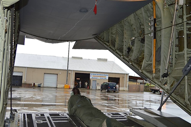
One such plane took off into heavy downpours Friday afternoon from St. Croix’s Henry Rohlsen Airport, lumbering and rumbling loudly as it receded and disappeared into thick clouds not much lighter than the dark, Air Force gray of the tubby airship.

"He is the loadmaster," explained Losurdo. The loadmaster is responsible to see that the plane’s load is at a safe level and distributed and secured properly.
Friday’s flight was into a tropical depression that had not yet formed into a storm. The flight would be a "low level invest," at about 1,500 feet or less, Losurdo said. Flying at a low height allows the plane’s radar and other equipment to get a picture of what is happening inside the storm, what wind speeds, directions and air pressure are like, said Losurdo.
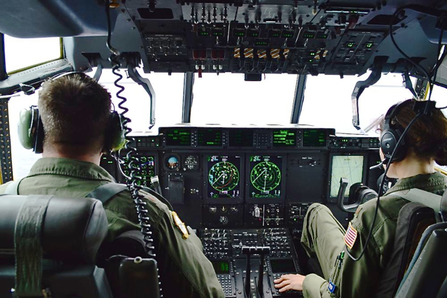
There was a little turbulence, especially when the plane was in the midst of the heaviest weather, and at one point the windows grew nearly as dark as night, then flashed brightly with lightning for a brief moment. While the flight crew flew the plane from the cockpit, the scientific staff and the rest of the crew made themselves comfortable in the aircraft cabin. Unlike a commercial flight, there were few windows and instead of padded bucket seats in rows, everyone sat on canvas benches with red cloth meshing as a seat back and a wall of places to clip and attach gear. Despite the lack of a window view, lack of cushioning and tray, it was much more comfortable than flying coach – mostly due to the unlimited legroom. And once aloft, you can lie down on the seats, like a cot.
Unlike a commercial flight, a steady rumbling of engines makes conversation difficult and earplugs a good idea. The crew works quietly, with headphones on, making notes of wind speeds, temperature and so on.
Part of Friday’s mission was to get a close look at the wind patterns near the ocean surface and see if the depression and storm was beginning to develop a circular pattern, said Lt. Col. Roy Deatherage, the mission commander. Deatherage has been coming to St. Croix with the Hurricane Hunters since 1996.
"So far it looks like its one wave," rather than a circular system, Deatherage said. "Maximum winds are at 40 knots in the northeast and it is moving at about 25 miles per hour through the atmosphere," he said. "That makes it hard for the storm to intensify because there is more wind shear," he said. Storms typically move at about 12 knots, or about half this speed, allowing them to become more organized more quickly, he said.
Flying the plane into the storm gives a different perspective and different sets of measurements than satellite imagery and radar, he said.

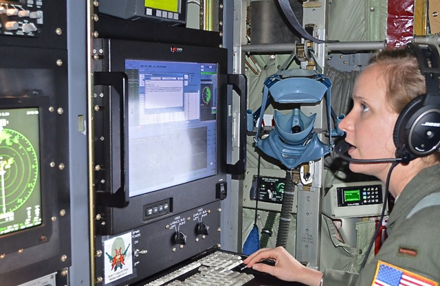
The plane circles the center of the low pressure system, periodically veering directly across it form various angles at the direction of the National Hurricane Center in Miami, Fla. 2nd Lt. Leesa Froelich spends part of the flight peering down at the waves, marking down wind direction and speed estimates based on the appearance of the wave surfaces. At other times she monitors radar and instruments showing temperatures and wind speeds. Every 10 minutes she takes a new set of measurements, making a line on a video screen that shows the flight path winding like a vine, with stems and twigs branching off to show temperatures and wind speeds.
Another screen shows an iridescent rainbow of overlapping lines, displaying the information from the Stepped Frequency Microwave Radiometer, or "Smurf," a rectangular box underneath the starboard wing, that measures the wind speed and direction right at the water’s surface.
"What we are looking for is a vortex," said Froelich, who flew her first storm with the Hurricane Hunters in 2013 (See Related Links below)
Sometimes they also drop sonds – instruments to measure the air and water temperatures in the storm’s eye – to get detailed information, she said. The warmer the center of the storm, the more it is likely to strengthen, and vice versa, she said.
"For example, Hurricane Arthur became an extra tropic storm, it became cooler in the eye, which took strength away from it," Froelich said. Arthur, the first named hurricane of 2014, made landfall in North Carolina July 3, with 101 mile per hour winds.
The Hurricane Hunter team seems motivated by a love of what they do.
"I joined because I like to fly and I like weather, so it worked out really well for me," said Barnaby.
"I’ve wanted to do this since I was a little kid," Froelich said. She grew up in Tampa Bay and studied meteorology at Florida State University before joining the Hurricane Hunters.
Friday’s flight did not find a fully formed vortex, but the plane could not check every angle, said the flight navigator, Lt. Col. Malcolm Shannon, who, like Deatherage, sported a patch saying he had flown more than 5,000 hours.
"Once it is closed off, then it becomes a tropical depression, but we cannot confirm that right now," Shannon said.
"We had to make sure to avoid Hispaniola," because of flight restrictions over Haiti, Shannon said.
"If the system is closed off, it happened over Hispaniola and we could not get the data," he said. That restriction affected measurements of the southwest quadrant of the storm, which is the slowest and hardest to measure in any event, he said.
While it had not organized yet, "all the models say it will intensify to a tropical storm somewhere around the Bahamas," Shannon said. And two days later, that is what happened.
According to the unit’s website, the Hurricane Hunters began in 1943 as a bar room dare, when two Army Air Corps pilots challenged each other to fly through a hurricane. On July 27, 1943, Maj. Joe Duckworth flew a single-engine North American AT-6 "Texan" trainer into the eye of a hurricane. Duckworth flew into the eye of that storm twice that day, once with a navigator and again with a weather officer. Those flights are generally considered to be the first flights into a storm for data gathering.
They provide surveillance of tropical storms and hurricanes in the Atlantic Ocean, the Caribbean Sea, the Gulf of Mexico and the central Pacific Ocean for the National Hurricane Center in Miami. The unit also flies winter storm missions off both coasts of the United States.


