
St. Croix Woman Faces $20,000 Bail After Surrendering to Fraud Charges

St. Croix Man Charged with Domestic Violence Following Assault

Man Shot in Head on St. Croix, Airlifted to Mainland for Treatment

Weekly Weather Forecast With Jesse Daley

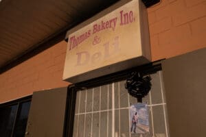
Thomas Bakery Founder Leaves Behind a Baking Dynasty

When Naydyeyah Acoy-Thomas thinks about her grandfather, Andrew F. Thomas, she remembers a mentor, a mediator, a sharp dresser, a storyteller, and a man with a great sense of humor — and she remembers how her grandfather, known to many as “Pop,” made friends wherever he went.
“We couldn’t go anywhere with Pop, because every minute somebody’s stopping to talk to him — and he was a very social person,” she said. Whether at the airport or visiting the states, Acoy-Thomas recalled how her grandfather, an avid traveler, made “several new friends along the way.”
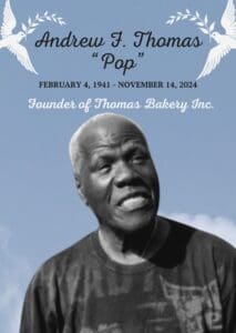
Thomas, the acclaimed founder of Thomas Bakery and Deli, died Thursday. He was 83.
Born on Trinidad in 1941, Thomas moved to the Virgin Islands in the early 1970s with his family. In his early years, he worked for Scotty’s Bakery in Peter’s Rest, Charles Harwood Hospital, and at the St. Croix refinery, then owned by Hess Oil. His granddaughter, Acoy-Thomas, said a layoff at the refinery prompted Thomas to consider starting a business.
“And he thought about the work he did as an apprentice in a bakery growing up in Trinidad and incorporated those recipes with his grandma’s recipe of making bread,” she said. “That’s where the idea to open a bakery came about.”
Thomas’s daughter, Andrea, said the bakery’s first incarnation was a wooden shed Thomas built behind their Strawberry Hill house in 1984.
“After being reported, and several attempts to shut him down, he was forced into compliance, which prompted him to get the necessary paperwork to open Thomas Bakery as an actual establishment. The people loved his bread, and that encouraged him to keep going,” Acoy-Thomas said.
The first commercial location opened on 33 King Street in Christiansted. Other locations in Estate Diamond and Frederiksted followed.
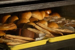
Today, Thomas’s sought-after titi bread and butter bread can be found at locations in: Castle Coakley, run by his daughter Andrea; Frederiksted, owned by his son Niel; Christiansted owned by his son Gary; and Decatur, Ga., owned by his son and grandson, Ryan and Kye.
Though he nominally stepped down from running the business, Thomas continued showing up to the bakery to oversee production and staff, prepare raisin rolls, supervise his grandchildren, and — occasionally — sneak one of his famous currant rolls.
Acoy-Thomas said her grandfather wanted his family to continue the baking tradition. His grandson, Elijah, vowed to keep Thomas’s legacy alive at the Castle Coakley location, and his children, grandchildren, and staff plan to keep the businesses going for years to come.
Thomas is survived by his wife, Grace Thomas, five children, 24 grandchildren and 24 great-grandchildren.
Beyond Hurricane Season: Year-Round Earthquakes Near the U.S. Virgin Islands

As hurricane season draws to a close, let’s examine another powerful visitor to the Virgin Islands: earthquakes. Earthquakes are common around the Virgin Islands and across the Caribbean region throughout the year. A powerful quake that recently struck near Cuba reminds residents and visitors in the Virgin Islands about the importance of earthquake safety.
The Source previously reported information about Caribbean earthquakes in an interview with Elizabeth Vanacore, PhD, a seismologist and a researcher at the Puerto Rico Seismic Network (PRSN). The PRSN, which also operates under its Spanish name, Red Sísmica de Puerto Rico, is affiliated with the University of Puerto Rico Mayagüez Department of Geology. Based in the city of Mayagüez on the west coast of Puerto Rico, the organization constantly monitors the Virgin Islands and Puerto Rico to help keep Virgin Islanders safe and informed about earthquakes and potential tsunami waves.
After a magnitude 6.8 quake rocked the island of Cuba on Nov. 10, the Source reconnected with Vanacore to obtain an update about Caribbean temblors and what people can do to be prepared.
The Puerto Rico Seismic Network Explained
“The PRSN is the authoritative seismic monitoring network for Puerto Rico and the Virgin Islands,” Vanacore stated. “The PRSN is in charge of monitoring and disseminating information about earthquakes in the region,” she said.
“Notably, PRSN is part of the Advanced National Seismic System, which means [that] our earthquake information is published on the United States Geological Survey (USGS) webpage,” Vanacore explained. “Additionally, the PRSN conducts research on the earthquakes [that occur, as well as] related hazards [caused by a quake] throughout the region,” Vanacore continued.
As was reported in a previous Source interview with Vanacore, “The PRSN and our sibling network, Puerto Rico Strong Motion Program (PRSMP), operate seismic [instruments called] broadbands and accelerometers in the Virgin Islands,” noted Vanacore. “The broadband will detect the large magnitude events from the other side of the world, while the accelerometer is not sensitive enough to sense events at such distances. The accelerometers really are most useful for local large-magnitude events,” she added.
Data obtained from accelerometers include measurements of “peak ground acceleration” that occur during an earthquake. This information is ultimately displayed on widely accessed maps, including earthquake Shakemap, a website that shows global earthquake data in real-time from around the world and is operated by the USGS. PRSN and PRSMP also create Shakemaps and Shakecasts, which are published on the websites of the organizations.
In addition to monitoring quakes, PRSN collaborates with emergency management agencies and organizations to ensure that the public is informed about any dangers related to a seismic event.
“There are over 200 real-time seismic stations streaming into the PRSN, as well as sea level data from across the Caribbean,” Vanacore stated. “In the case of a significant event (a magnitude 3.5 on the earthquake magnitude scale or greater), the PRSN will send out initial information within five minutes of the earthquake. The priority is to [share the data with] emergency management agencies across Puerto Rico and the USVI, but this information is also published with a web banner at the top of our webpage and on social media. The earthquake is then reviewed by a duty analyst and updated with the final information [and then published on sites including the USGS],” Vanacore explained.
Magnitude 6.8 Quake Strikes Cuba
Vanacore acknowledged the recent strong earthquake that struck near Cuba on Nov. 10, stating that the seismic episode occurred on a fault known to experience strong quakes. However, she also provided reassurance that the tremor is not indicative of a looming threat of a similar earthquake near the USVI.
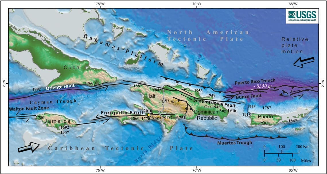
“The [magnitude] 6.8 earthquake [on Nov. 10] near Cuba occurred near or within the Septentrional-Oriente Fault Zone,” according to Vanacore. “The focal mechanism of the event is consistent with a left-lateral fault with strike-slip motion similar to the San Andreas [Fault, located in California],” she said.
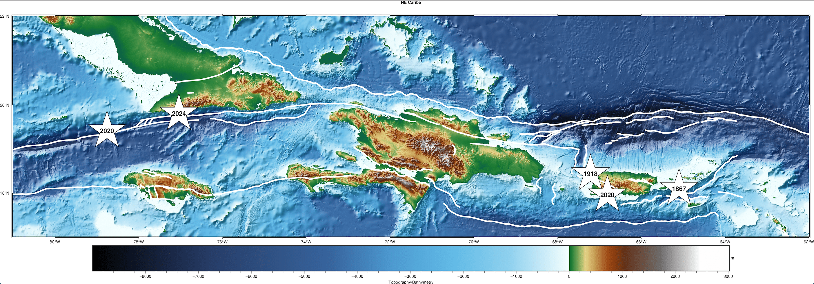
“This type of fault would be consistent with the expected tectonics of the area where the North American Plate is moving laterally relative to the Caribbean Plate. Notably, this earthquake is about 185 km east of [a] magnitude 7.7 earthquake that occurred near Jamaica in 2020, which is also associated with the plate boundary,” Vanacore stated.
“Earthquakes in this region do not signify that something similar or stronger near the USVI [or] PR,” she added.
The Magnitude and Power of a Temblor
Vanacore shared how an earthquake’s magnitude can be interpreted.
“Magnitude is a quantitative measure of the energy released during an earthquake, [and] each change in magnitude is [equivalent to a] 32 [times] change in energy,” Vanacore said. “For instance, a magnitude seven earthquake releases 32 times more energy than a magnitude six earthquake,” she explained. “To put things in perspective, a magnitude seven earthquake would release about the same energy as approximately 478,000 tons of TNT [trinitrotoluene], [which is equal to] 30 Hiroshima bombs. A magnitude six earthquake would release the energy of about 86,000 tons of TNT, [which is equal to] 6 Hiroshima bombs.”
Interestingly, the scale of earthquake magnitude does not have an upper limit, and several scales are utilized to determine the size of a quake.
“Magnitude scales can be used to describe earthquakes so small that they are expressed in negative numbers. The scale also has no upper limit,” according to information from Michigan Technological University.
Still, Vanacore noted that there is a physical limit to how powerful a quake could be.
“While theoretically there is no limit to earthquake magnitude, there is a physical limit,” Vanacore said. “Earthquake magnitude used for large earthquakes is directly related to the size of the fault. The limit on Earth is the size of the fault itself, [and] no fault large enough to generate a magnitude ten event currently is known to exist on Earth. A fault would need to extend around most of the Earth to be capable of a magnitude ten,” Vanacore stated. “The largest [seismic] event on record is a magnitude 9.5 that occurred in Chile in 1960 [and] required [a] rupture along a fault approximately 1000 miles long [to attain the high magnitude],” she added.
Vanacore also mentioned that the “Richter scale” is well-known, however more modern versions of this magnitude scale are currently utilized.
“The Richter scale is a colloquial term often used by the media to mean magnitude. This scale was originally developed in 1935 for Southern California. The modern version of this scale is referred to as ‘local magnitude’ (ML) and is empirically derived for each individual region. However, for large events like the one in Cuba, this magnitude (local) is not used; rather it is a magnitude called ‘moment magnitude,’” explained Vanacore. (More information about earthquake magnitude scales is available from the USGS here.)
“The amount of shaking experienced during an earthquake, however, depends not only on the amount of energy released but also other factors such as where you are relative to the earthquake and the type of building in which you reside,” Vanacore noted. “Shaking measured by intensity is a qualitative measure of the shaking experienced at a location during an earthquake, [and] this is why ‘Did You Feel It?’ reports are critical information for seismic networks,” she added.
Quakes “Do Not Follow a Schedule”
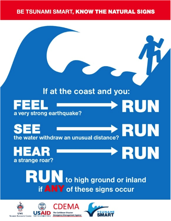
Vanacore stressed that earthquakes are unpredictable. While it has been a long time since a powerful quake affected the local islands, shaking could occur at any time, and it is essentially impossible to forecast when or where it may strike. Tsunamis generated by quakes are also a major threat to the islands.
“The most significant earthquake in recent history for the Virgin Islands is the 1867 Anegada Passage earthquake and tsunami. This stemmed from a magnitude 7.3 earthquake roughly 20 km southwest of St. Thomas,” Vanacore stated in a previous Source interview. “[The temblor] generated a tsunami with a maximum height of approximately 15 meters. However, even earthquakes from a distant location can generate tsunamis impacting the Caribbean,” Vanacore added.
“Earthquakes unfortunately do not follow a schedule,” Vanacore said. “Infamously, the Parkfield Earthquakes [a set of quakes along a section of the San Andreas Fault in California] that were thought to follow a well understood pattern was originally predicted to have another magnitude 5.5 earthquake [or higher] between 1985 and 1993 after a pattern of events in 1857, 1881, 1901, 1922, 1934, and 1966. [However,] no such earthquake occurred until 2004.”
“The reality for the USVI and Puerto Rico is that we are in an active tectonic region dominated by the subduction of the North American Plate beneath the Caribbean,” Vanacore described. “This results in complex faults throughout the region and a consistent earthquake and tsunami hazard for the region. Currently, the USGS is leading an update to the seismic hazard maps in the region (USVI and PR) that will be published in 2025. This update includes collaboration with UPRM and PRSN scientists,” she continued.
Earthquake Safety
While it may not be possible to predict exactly when or where shaking could happen, individuals can be prepared for a disaster.
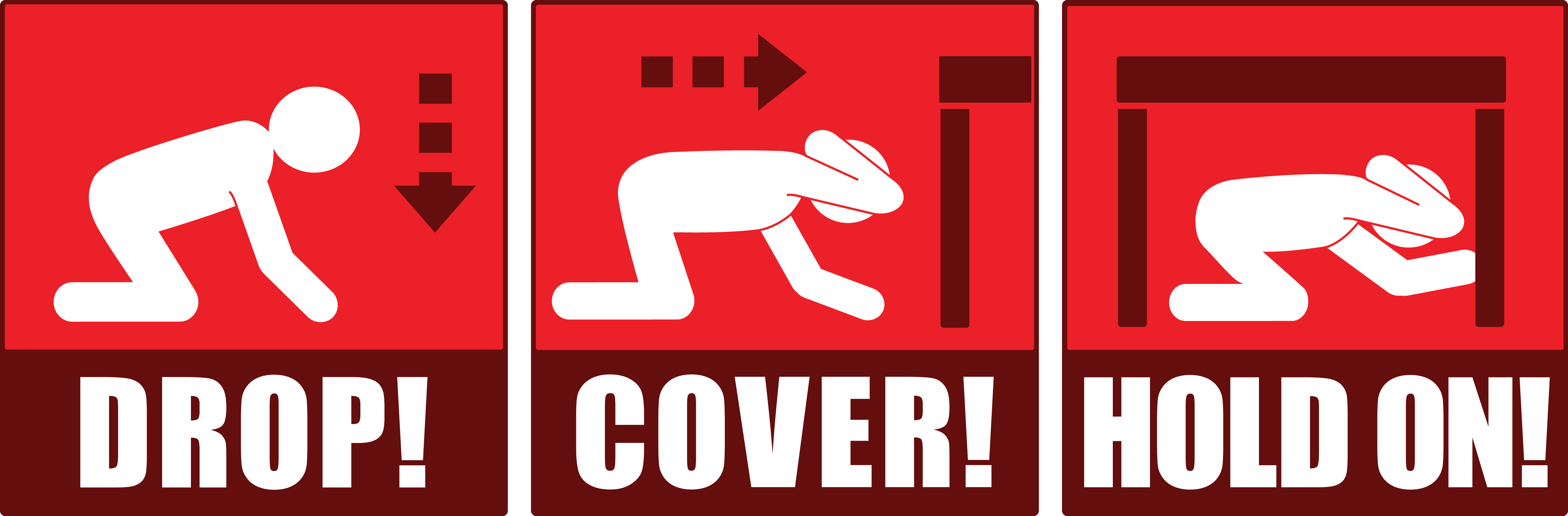
“During an earthquake, it is critical for people to ‘Drop, Cover, and Hold On’ to protect themselves,” Vanacore advised.
“If you are driving your car [during a] small [seismic] event, you might not perceive the earthquake,” she explained. “However, if there is a larger event, recommended actions become situational. For instance, if you are in a safe area without electric poles or trees, then you should come to a stop, pull the handbrake, and protect your head with your arms,” Vanacore cautioned.
“For more information on how to protect yourself before during and after an earthquake, see the PRSN educational website. [Individuals] can also check resources from the Virgin Islands Territorial Emergency Management Agency (VITEMA)” she advised.
Vanacore concluded her remarks by encouraging the public to get involved in drills and exercises that are intended to familiarize residents and visitors across the region to be ready in the event of an earthquake or a tsunami.
“Understanding the hazards due to earthquakes and tsunamis in the region is constantly improving thanks to efforts of scientists and emergency managers both in the USVI and Puerto Rico,” Vanacore declared. “Relationships across the islands are critical to our continued resilience, [and] while earthquakes and tsunamis cannot be predicted, we can all prepare for them,” she noted.
“[Preparing for quakes] includes participating in activities like [the Great] ShakeOut and Caribe Wave, as well as taking ownership of your own preparedness at home. The PRSN and VITEMA have information available to learn about earthquakes and tsunamis, and most importantly, how to prepare for them,” she recommended.
Weather information is also updated regularly on the Source Weather Page, the Source YouTube Channel, and on the official website of the National Weather Service in San Juan, Puerto Rico. USVI residents and visitors can also sign up for emergency alerts, including earthquake notifications, from VITEMA.
Op-Ed: Our National Bird and St. Croix’s Onetime Sugar Economy

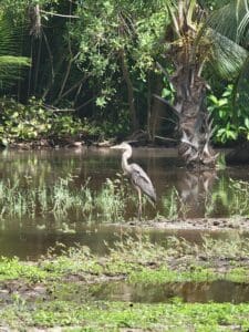
I got to thinking the other day as I was conducting a hike that my audience didn’t know why the Yellow Breast became our territory bird. Nor did they know that we had native parrots, very large birds, but they are now extinct.
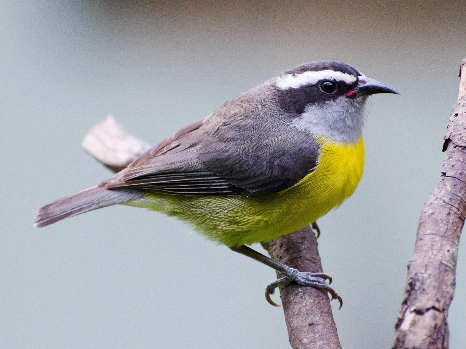
The Yellow Breast (Coereba flaveola) is called by many common names such as Bananaquit, Sugar Bird, etc., in the Virgin Islands. But why did we choose the Yellow Breast as our territory bird?
Believe me, St. Croix was not called the “Garden Spot of the West Indies or the Caribbean” or “The Garden Spot of the Antilles” for nothing due to it sugar history. A book titled “Stick From the Hawk Nest,” by our beloved late native naturalist George A. Seaman, mentions this about our territory bird: “In our case, the Yellow Breast was chosen because of its ubiquitous distribution, cheery and friendly disposition, and above all because of its historic association with the sugar economy of the Virgin Islands.”
Therefore, one can say from the first primitive animal mill in the colonial era of the Virgin Islands to when Estate Bethlehem Sugar Factory on St. Croix phased out sugar production in 1966, the Yellow Breast was part of the sugar industry of these islands. These birds used to fly into the sugar factories in the hundreds and eat the sugar. The bird got its name, like I mentioned before, by constantly entering the sugar factories, particularly the curing-houses at different sugar estates through the barred windows.
The managers and overseers of estates on St. Croix gave the birds a bad reputation for stealing sugar from the hogsheads. However, older Crucians believed it was the swarms of flies that attracted the Yellow Breast, which led them to the newly made muscovado. The birds were such a part of the Virgin Islands culture and history. It is for this reason one of the common names was Sugar Bird. They love sugar. On the other hand, the word Bananaquit derived from its yellow color and the English word quit, which refers to any bird of the order Passeriformes, which includes more than half of all bird species.
Nonetheless, the Yellow Breast has been identified with the making of sugar in the Virgin Islands. The bird is recognized by its short, strongly curved bill, black above with a dark gray throat, and bright yellow belly, thus the common name Yellow Breast. Other distinctive features include white eye stripes extending from the nostril to the nape.
Believe me, these birds are bold, noisy, and acrobatic. They are constantly in motion, flitting their wings as they feed in forests on flower nectar, insects, fruits, and spiders. They also are attracted to gardens and patios if you have sugar water feeders for them. At times, they might just invite themselves to the family sugar bowl in your house. By the way, they love to sing. Their singing has been described as “zee-e-e swees se tee.”
On May 6, 1970, the Virgin Islands Legislature passed Bill No. 4263 naming the Yellow Breast as our official bird. Now, what about our native parrot of the Virgin Islands? The Brown-Throated Parakeet, known on St. Thomas’ northwest side, particularly the Magens Bay area, is endemic to the U.S. Virgin Islands, also to some French West Indies Islands, and other countries in Central and South America. They are also known as St. Thomas Conure or Brown-Throated Conure.
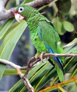
However, the parrot that I am talking about is distinguished and only found on St. Croix. In the 1730s, Reimert Haagensen, a Danish planter of St. Croix, mentioned in his book, “Description of the Island of St. Croix in America in the West Indies,” parrots on St. Croix. In the countryside, Haagensen mentioned you can find both blue doves, the scaly-naped pigeon (Columba squamosa), and the Puerto Rican parrot (Amazona vittate).
“There are many parrots on the island. They are green in color and their nests are found in the forests by slaves, who sell them for two to three marks apiece. It is an easy matter to teach them to talk. Through found quite commonly on the island, they would be worth 100 Rdlr here,” noted Haagensen. Haagensen talked about when the grain ripened in the fields, how parrots appeared in large flocks to eat the grain. To protect the grain, managers and overseers of estates on St. Croix had enslaved Africans posted in the fields to save their corn crops from being eating by parrots.
Slaves in the grain fields on estates were armed with fowling pieces to keep the parrots away. This would continue daily until the crop was harvested from the fields. It is interesting to note that both the Yellow Breast and the parrots had a bad reputation of stealing sugar or eating grain crops. The sad note is that our native parrots became extinct due to extensive deforestation on St. Croix, especially old-growth forests, and the clearing of thousands of acres for agriculture, thus destroying habitats, particularly in the countryside of the island.
These native parrots were probably mostly green as Haagensen described them, although they could have a red band above their beak and blue on their head and wings. They might also have featherless rings around their eyes or white rings around their eyes. They could have been about 12 inches long, which is about the size of the parrot in Puerto Rico. The St. Croix parrot could have been a subspecies or related species to the Puerto Rican parrot.
The Puerto Rican parrot is now rare and an endangered species due to many factors, mainly human impact on the forest habitat of the island. According to historians, the island supported a parrot population of about 100,000 to 1 million at the end of the 15th century. In 1968, there were only two dozen individual birds in the wild. By 1994, the population of the parrot had risen to 36 birds and six breeding pairs.
Believe me, it is a struggle for scientists to increase the population of parrots in Puerto Rico. There is a lesson in all of this: protect the natural and cultural resources for a healthy economy of these islands.
— Olasee Davis is a bush professor who lectures and writes about the culture, history, ecology and environment of the Virgin Islands when he is not leading hiking tours of the wild places and spaces of St. Croix and beyond.
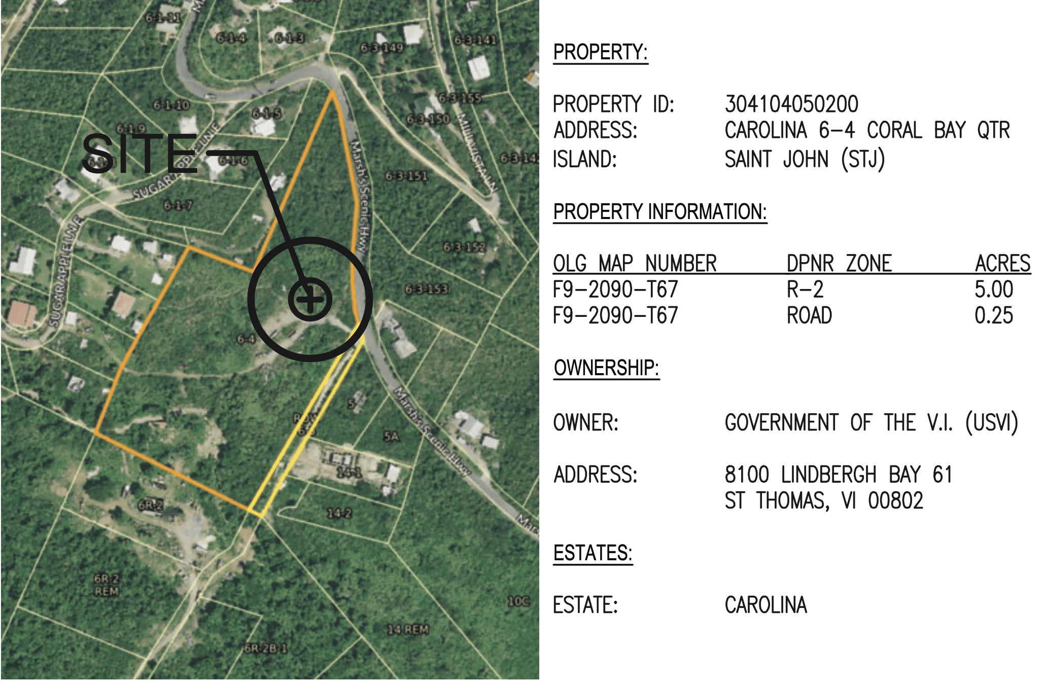
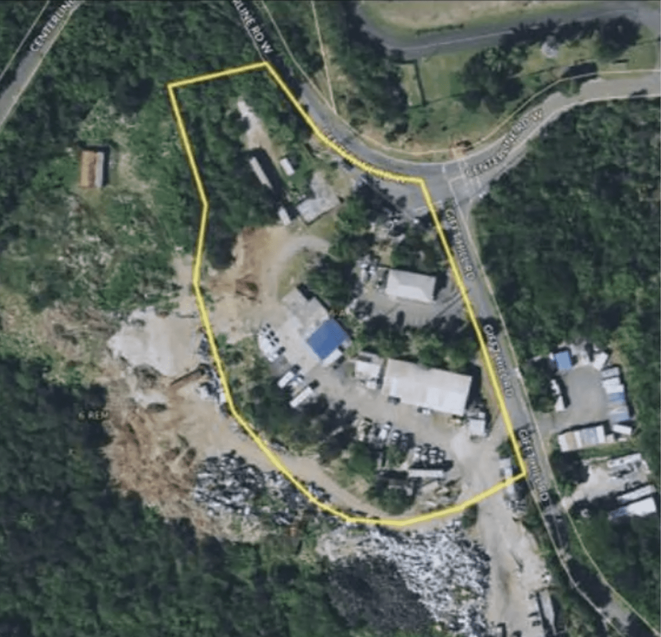
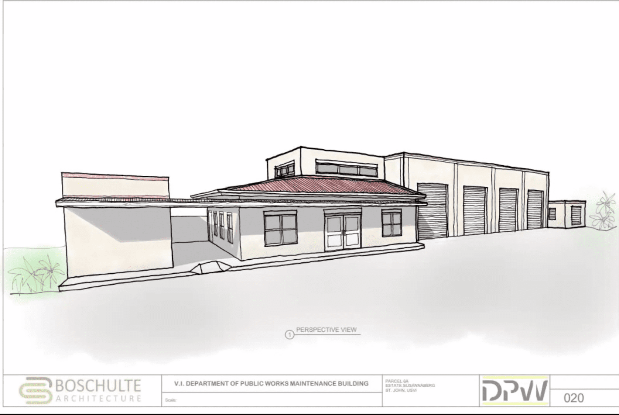
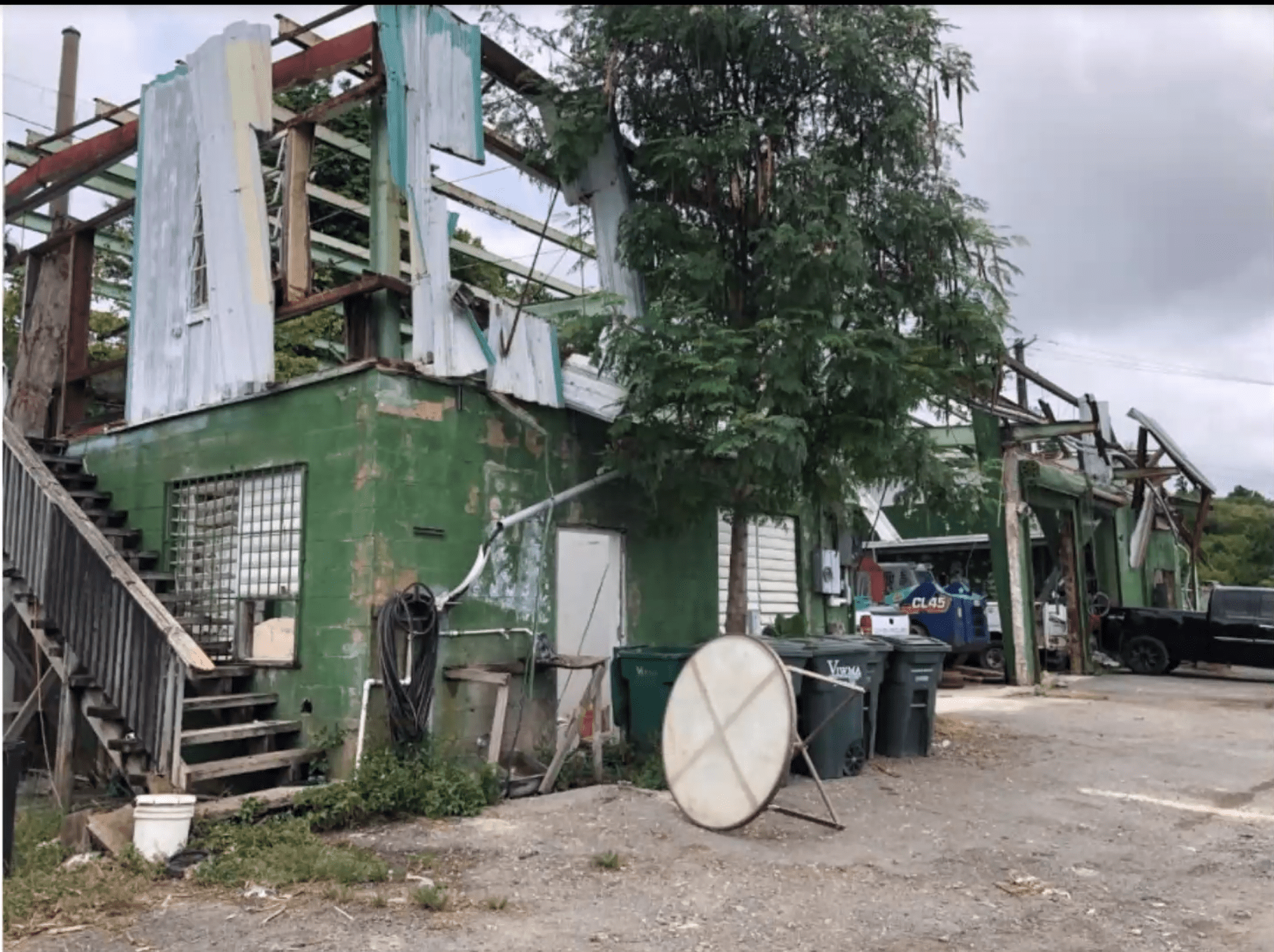
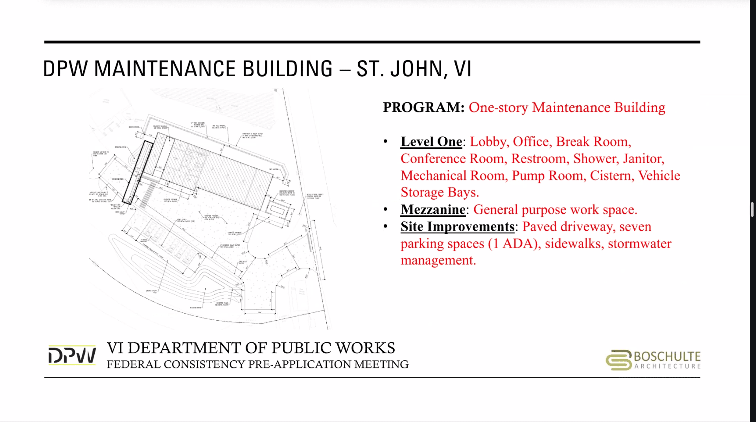
STJ CZM Approves Coral Bay Cell Tower and Hears Plan for New Public Works Facility


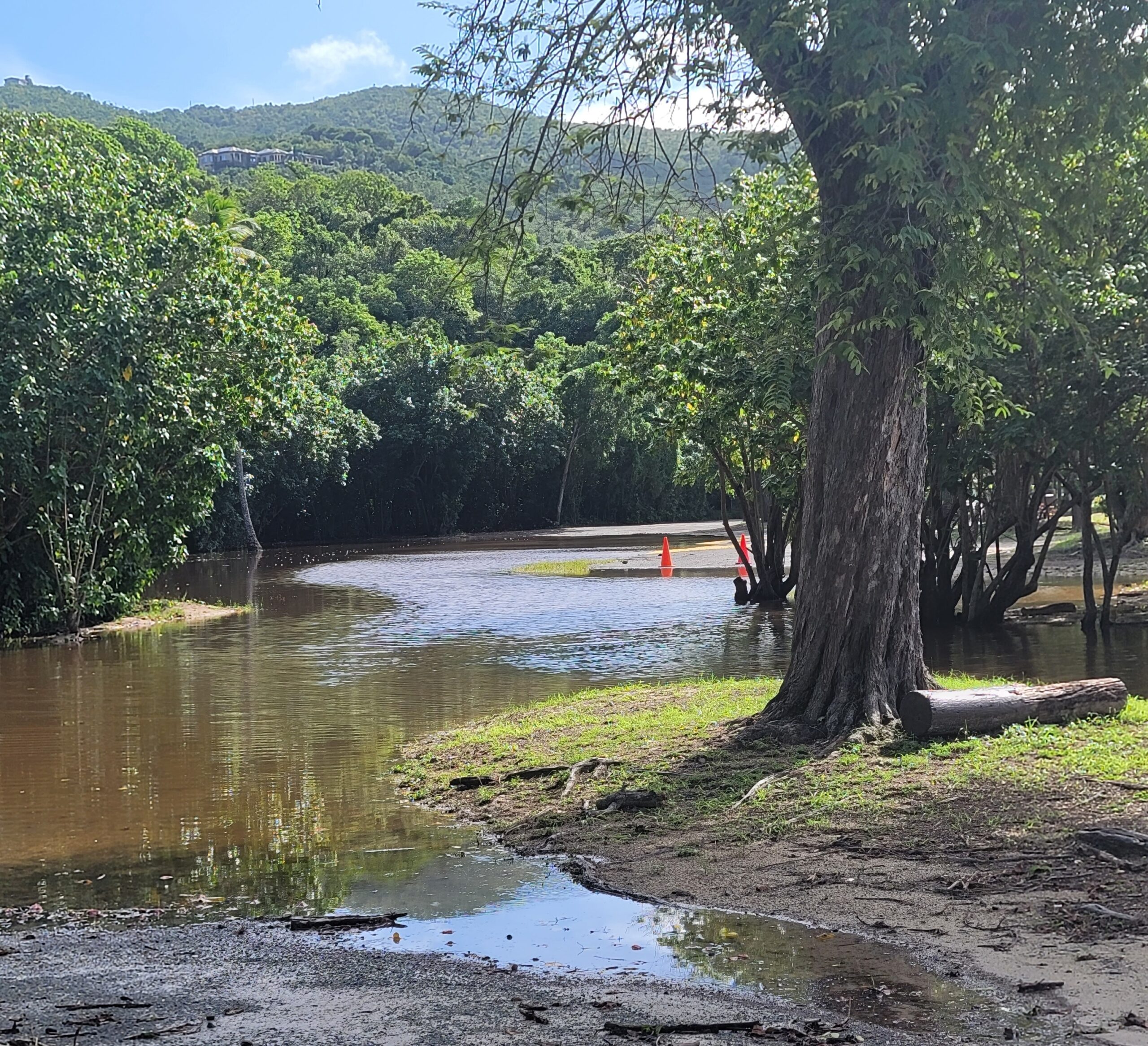
Magens Bay Remains Closed Amid Flooding Rains, Hazardous Seas

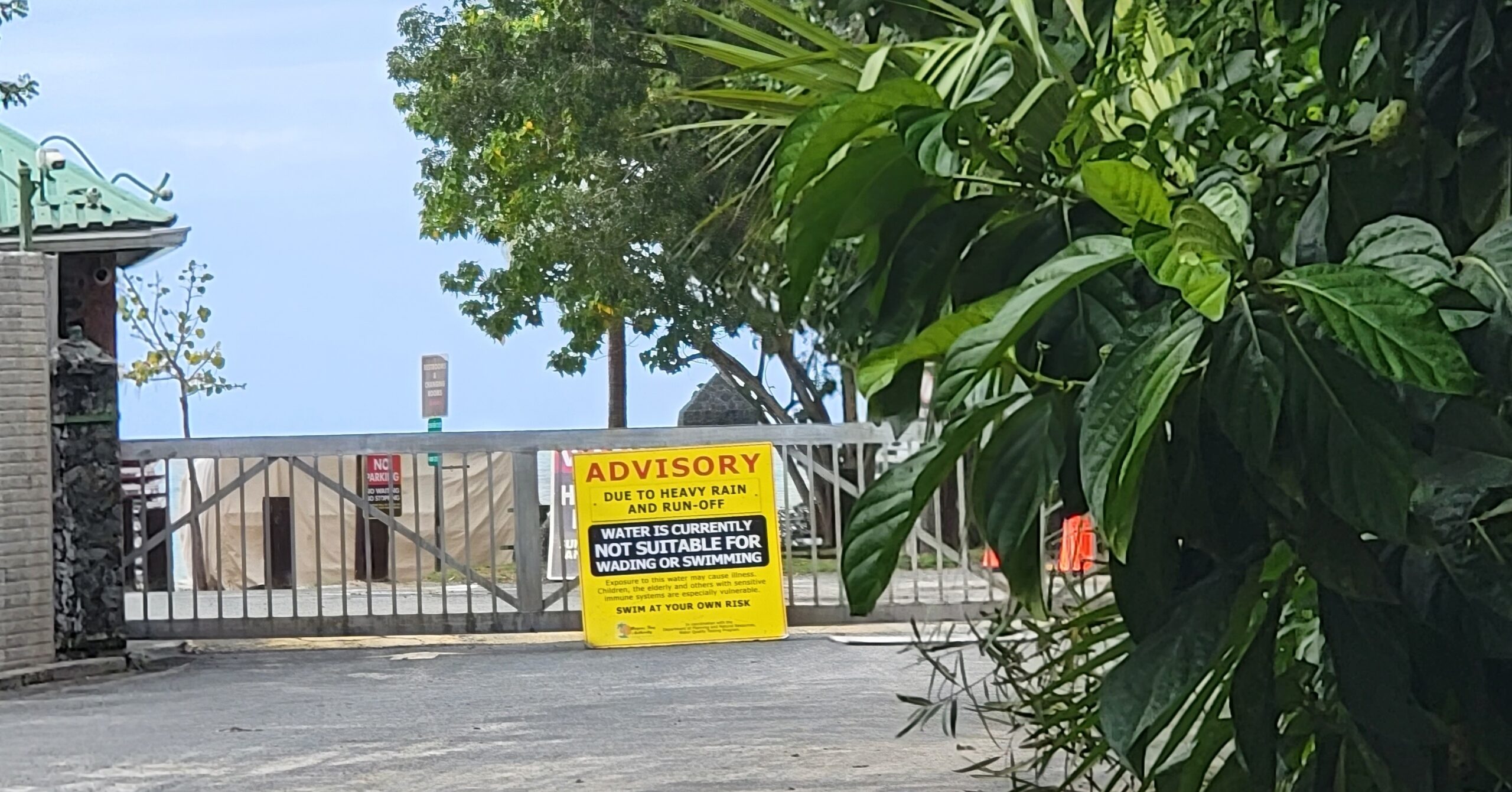
After more than a week of heavy rain, Magens Bay Beach on St. Thomas remained closed Friday amid flooding and hazardous sea conditions.
The authority first announced the closure on Monday along with a “Red Flag Status” — signaling that rough conditions such as strong surf and/or currents are present. While the gate is closed to vehicles, walkers are still allowed but not encouraged, it said.
According to the National Weather Service in San Juan, Puerto Rico on Friday, hazardous sea conditions and showers are expected to persist over the next few days. Follow the Source Weather Page for updated information.
“It is crucial to emphasize that swimming at these beaches is also discouraged, since lifeguard assistance will not be available and water testing is currently in process. The Magens Bay Authority further advises that persons that disregard this notice and enter the water, do so at their own risk,” the notice said.
“Rest assured, the Magens Bay Authority is committed to reopening the beach quickly, however the well-being and safety of all beachgoers and staff of the MBA is our priority,” it said.
For more information, call 340-777-6300, email info@magensbayauthority.org or visit www.magensbayauthority.org.
Starry Walker at Bajo el Sol Sunday


