

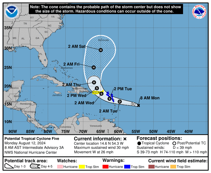
Tropical storm and flood watches have been issued for the U.S. Virgin Islands and Puerto Rico as a tropical wave continues moving toward the Caribbean. The disturbance is forecast to reach the local area around Tuesday night.
As of 8 a.m. on Monday, the National Hurricane Center explained that the tropical wave, currently called Potential Tropical Cyclone Five, is located approximately 750 miles to the east-southeast of St. Thomas, USVI, and moving toward the west across the Atlantic at approximately 26 mph, packing winds of roughly 30 mph.
The storm is expected to intensify into a tropical depression on Monday and further intensify into a tropical storm, with maximum sustained winds of at least 39 mph, before reaching the USVI around Tuesday night. If the storm intensifies into a tropical storm, it will be given the name “Ernesto,” the fifth named cyclone of the 2024 Atlantic Hurricane Season.
Multiple tropical storm watches and warnings have been issued across portions of the Lesser Antilles. As of Monday morning, the U.S. Virgin Islands and Puerto Rico are under a tropical storm watch, and a flood watch will be in effect from Tuesday night until Thursday morning.
“A Tropical Storm Warning means that tropical storm conditions are expected somewhere within the warning area within 36 hours, [and] a Tropical Storm Watch means that tropical storm conditions are possible within the watch area, generally within 48 hours,” the NHC explained. (A video from the Source explaining the difference between a Tropical Storm Watch and a Tropical Storm Warning can be viewed here.)
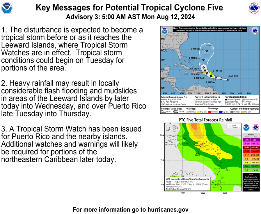
“Potential Tropical Cyclone Five will bring strong gusty winds and periods of heavy rain, with the potential for flash flooding and mudslides,” according to an update on Monday from the National Weather Service in San Juan, Puerto Rico.
“The first rainbands will arrive by Tuesday afternoon, becoming more frequent and heavier Tuesday evening through early Wednesday morning,” the NWS said. “Hazardous marine and coastal conditions are also expected, beginning as early as Tuesday evening,” the NWS added.
The weather forecast and storm track can change rapidly. USVI residents and visitors are encouraged to follow the situation very closely and can find information regarding hurricane preparedness from the Virgin Islands Territorial Emergency Management Agency and the National Oceanic and Atmospheric Administration.
“Now is the time to check your emergency plan and take necessary actions to secure your home or business,” the NWS advised. “Deliberate efforts should be underway to protect life and property. Ensure that your Emergency Supplies Kit is stocked and ready,” the NWS said.
“When making safety and preparedness decisions, do not focus on the exact forecast [storm] track as there are inherent forecast uncertainties which must be taken into account,” the NWS explained.
Weather Updates
The National Weather Service in San Juan, Puerto Rico, will provide continuous updates on the storm, and detailed information can be found on the NWS website. Weather forecast information, including severe weather alerts, is also available from the Virgin Islands Territorial Emergency Management Agency.
Finally, the Source Weather Page publishes a daily weather forecast and offers readers the opportunity to view weather forecast videos and disaster preparedness video segments.


