The Virgin Islands Cannabis Advisory Board on Thursday approved laboratory testing standards for cannabis products, clearing another major hurdle as the U.S. Virgin Islands moves closer to launching its long-awaited regulated cannabis industry.
The approved testing standards establish requirements for contaminants, heavy metals, microbial controls and product-specific testing for inhalable cannabis products, edibles, tinctures and topicals. The Office of Cannabis Regulation’s Executive Director Joanne Moorehead said the standards were designed with the Virgin Islands’ humid tropical environment in mind.
“I do think that ours might be a little more stringent, but that is really because we’re looking at environmental factors that affect our plant product grown here versus in other parts of the country,” Moorehead said.
Board members raised concerns about possible contamination from heavy metals in soil and water, particularly on St. Croix due to the island’s industrial history. Board member Dr. Gary Jett questioned whether soil testing is routinely conducted in the territory.
Moorehead acknowledged the concern and encouraged cultivators to test both soil and cistern water before growing cannabis.
“If it’s in your water and you’re using that water to water your plants, it’s the same thing. It’s still getting into your plant via the root system,” she said.
The board also discussed the recent federal rescheduling of medical cannabis from Schedule I to Schedule III under federal law. The change would recognize medical cannabis as having accepted medical uses under federal law and could ease some restrictions on research and business operations, though recreational cannabis would remain federally illegal.
Moorehead cautioned that the change applies only to medical cannabis and does not legalize recreational cannabis federally.
“It is not a wholesale rescheduling,” she said. “It does not make adult use or recreational marijuana or cannabis legal.”
Moorehead said the change could create new compliance and tracking obligations for medical cannabis businesses seeking federal registration through the Drug Enforcement Administration.
The board additionally reviewed a newly approved resolution giving previously unsuccessful dispensary applicants a one-time opportunity to amend portions of their applications to address deficiencies identified during the scoring process. Ownership changes will not be permitted under the amendment process, officials said.
Under the resolution, unsuccessful applicants will have 30 days to voluntarily submit revised application materials after receiving formal notification from the Office of Cannabis Regulation.
Moorehead also outlined the territory’s licensing process for commercial cultivators, explaining that applicants first undergo merit-based evaluation before receiving conditional approval. Final certificates to operate are issued only after applicants’ complete inspections and satisfy compliance requirements.
“We’re not trying to set people up for failure. We want them to succeed,” Moorehead said, describing the extensive back-and-forth process between regulators and applicants to ensure compliance before operations begin.
During her office update, Moorehead said medical cannabis registrations continue across the territory, with nine practitioners currently participating — five on St. Thomas and four on St. Croix — along with 44 active patients. She said the office continues reviewing applications and processing patient renewals as the program expands.
She also reported that several commercial cultivators are awaiting certificates to operate and could begin growing once final inspections are completed.
“We are right on the cusp for cultivation,” Moorehead said.
According to Moorehead, micro-cultivators and dispensaries are progressing through compliance reviews, while manufacturing and research-and-development applications are awaiting final scoring from evaluation committees. She added that third-party vendors and transportation providers remain pending as the office continues working through responsible vendor training requirements.
Members present at the meeting were Natalie Hodge, Louis Petersen, Dr. Gary Jett, Chris Jones, Bernisha Liburd, Dr. Katherine Kean.
After months of debate and consideration, the St. Croix Coastal Zone Management Committee decided to reject an application to construct a 150-foot tall communications tower in Estate Long Point and Cotton Garden sought by the Virgin Islands Government and Liberty Mobile as part of AT&T’s first responder network, or FirstNet.
The matter was discussed during a public hearing in February, during which residents and landowners voiced concerns about property devaluation, noise and potential environmental impacts. Those concerns and others were shared again during a CZM decision meeting in March, and committee members ultimately tabled a vote on the matter in order to gather more community input.
After brief remarks from attorney Kevin Rames, who is representing the applicants, and Wanda Perez, Liberty USVI’s senior manager for government affairs, commissioners shared that they still had misgivings about the development. Commissioner Aubrey Ruan said he had “a bad feeling in my stomach over this whole issue,” and commissioner May Cornwall said she hadn’t seen enough evidence to suggest that the Estate Long Point and Cotton Garden property was the only viable site for the tower.
Commissioners also questioned whether the applicants considered switching to an alternative site in Grapetree Bay, leading to several minutes of heated back-and-forth.
“We don’t want to be argumentative at all,” Rames said, “but… you simply cannot say that what has happened here is that we have rejected a suitable site in exchange for a site that we have invested in. The Grapetree Bay site — you may look at and think, from your own perspective, that it’s satisfactory, but it has been deemed outside of the appropriate zone and incapable of meeting the requirements of FirstNet.”
After voting to reject the application, commissioner Kai Nielsen acknowledged the importance of the project but said it was commissioners’ feeling that the assessments “weren’t sufficient to put it in its current location.”
“There are several other properties with property owners willing and able to provide land that we are to believe could fit the requirements once they are provided to us,” he said.
The committee then heard a presentation from the St. Croix Renaissance Group, which is seeking to build a reverse osmosis water production unit at St. Croix’s south shore industrial complex.
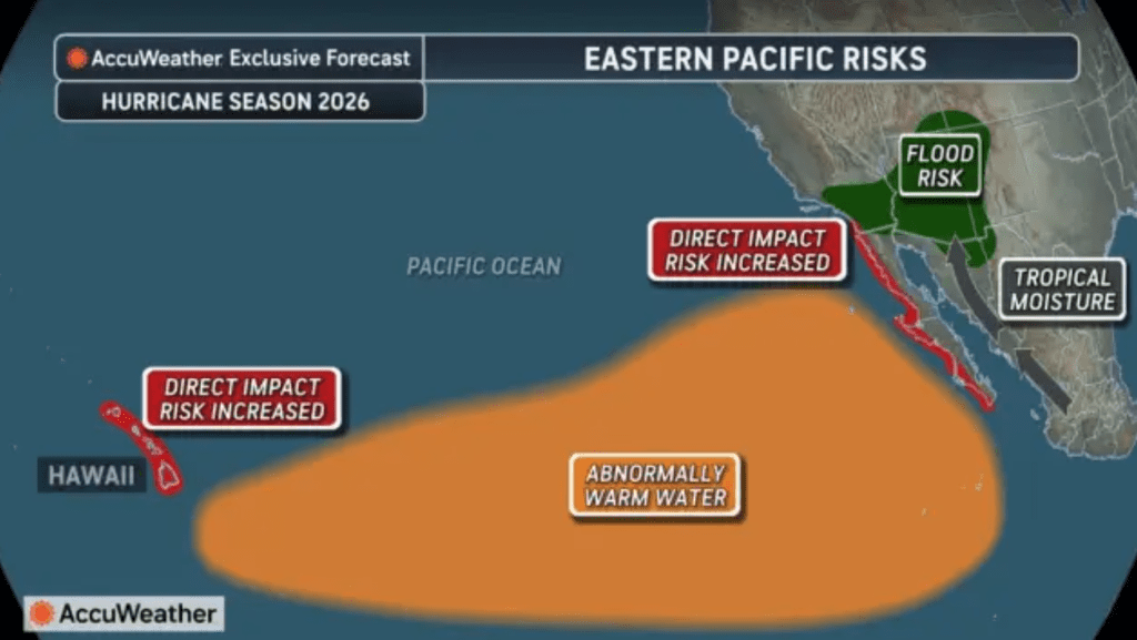
Caption: AccuWeather’s 2026 hurricane season forecast highlights elevated Eastern Pacific risks, including abnormally warm water, increased direct impact potential near Hawaii and parts of Mexico, and tropical moisture concerns. (Photo courtesy AccuWeather)
The National Hurricane Center will resume routine Tropical Weather Outlooks for the Atlantic basin on May 15, giving residents and visitors across the U.S. Virgin Islands another reminder that the 2026 Atlantic hurricane season is fast approaching.
The Atlantic hurricane season officially begins June 1 and runs through Nov. 30. For the U.S. Virgin Islands, the Atlantic basin is the key area to monitor, because it includes the Atlantic Ocean, Caribbean Sea and the Gulf.
The outlooks are a key place to check whether the NHC is monitoring areas of disturbed weather for possible tropical development. The May 15 restart also comes as forecasters continue to monitor the potential development of El Niño, which can influence hurricane activity differently across the Atlantic and Pacific basins.
Why Tropical Outlooks Resume on May 15
The Source contacted Alex DaSilva, lead hurricane expert at AccuWeather, for perspective on the May 15 restart of the NHC outlooks. DaSilva explained that the timing of the resumption of outlooks can help improve awareness ahead of the official June 1 start of the Atlantic season.
“May 15 marks the start of the Eastern Pacific hurricane season, and the NHC likely begins Atlantic outlooks at the same time for consistency between the two basins,” DaSilva said. “Starting both at the same time helps avoid confusion and also raises awareness in the Atlantic ahead of the official June 1 start of the season.”
Tropical cyclone seasons vary around the world depending on the basin and time of year. For residents and visitors in the U.S. Virgin Islands, the Atlantic basin remains the primary area to monitor. The National Hurricane Center states that the Atlantic hurricane season runs from June 1 through Nov. 30, while the Eastern North Pacific season begins May 15 and runs through Nov. 30. The Eastern North Pacific basin covers the area east of 140 degrees west longitude, and the Central North Pacific basin covers the area from 140 degrees west longitude to 180 degrees, with that season also running from June 1 through Nov. 30.
In the Southern Hemisphere, tropical cyclone seasons occur during a different time of year. For example, Australia’s official tropical cyclone season runs from Nov. 1 to April 30, according to the Australian Bureau of Meteorology.
NWS San Juan Urges Preparedness
The Source also contacted Yidiana Zayas-Rivera, a meteorologist with the National Weather Service in San Juan, Puerto Rico, for comments ahead of the NHC daily outlooks. Zayas-Rivera stressed that disaster preparedness remains important every year, no matter what the seasonal forecasts predict.
“Regardless of whether the season is expected to be more or less active, it is always important to focus on things we can control, and that is preparedness,” Zayas-Rivera declared. “We need to be prepared, because it only takes one hurricane to make a season active. Preparation, education, and our information are key to helping save lives,” she continued.
“Also, remember to follow official resources such as the NHC for the official intensity forecasts and forecast tracks of tropical systems, and the local San Juan Weather Forecast Office for more details on local impacts,” Zayas-Rivera noted.
El Niño Chances Continue to Grow
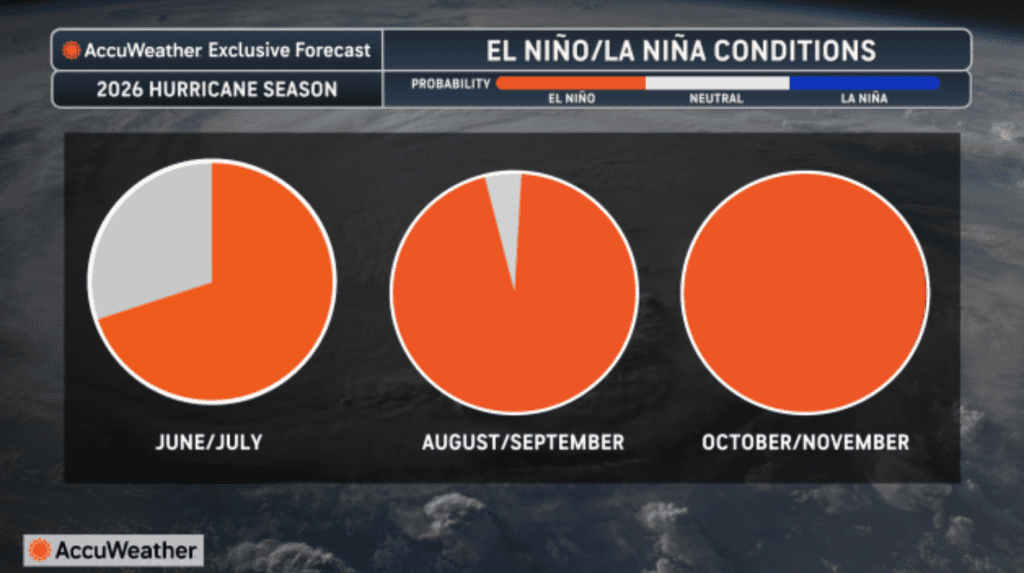
El Niño/La Niña conditions are shown for the 2026 hurricane season, with AccuWeather forecasting El Niño conditions becoming increasingly likely through the peak and latter part of the season. (Photo courtesy AccuWeather)
A major factor that may influence this year’s Atlantic hurricane season is the expected development of a strong El Niño weather pattern.
El Niño, which involves a warming of the equatorial Pacific Ocean, usually helps to increase wind shear—a change in wind direction and velocity with height in the atmosphere. In the Atlantic Ocean the increase in wind shear from El Niño helps to rip apart storms and prevent hurricane formation and intensification. This is the opposite of a La Niña cycle, when the ocean waters across the equatorial Pacific cool significantly. During La Niña, wind shear typically decreases in the Atlantic, and a reduction in wind shear can favor cyclone development.
The latest update from NOAA’s Climate Prediction Center was released on May 14 and adds additional context to the potential development of El Niño this year. In its latest ENSO Diagnostic Discussion, NOAA said ENSO-neutral conditions continued over the past month, and an El Niño Watch remains in place.
The update said El Niño is likely to emerge soon, with an 82% chance during May through July 2026, and continue through winter 2026-2027, with a 96% chance for December through February. NOAA also noted that confidence in the development of El Niño has increased since last month, though there is still uncertainty about how strong the event may become.
AccuWeather has highlighted the developing El Niño pattern in recent outlooks. In an April 29 summer forecast, AccuWeather reported, “El Niño is expected to develop early in the summer and will have a growing influence on the tropics and the broader weather pattern across the United States through the rest of 2026.”
In a separate AccuWeather report about the Pacific hurricane season, the outlet noted that El Niño could promote a surge in activity in 2026 across the Pacific region. The report quoted DaSilva as saying, “This could be an unusually active and potentially impactful year in the Pacific basin, unlike the Atlantic basin, where we are forecasting fewer storms than the historical average.”
Atlantic Season Could Be Less Active, But Still Dangerous
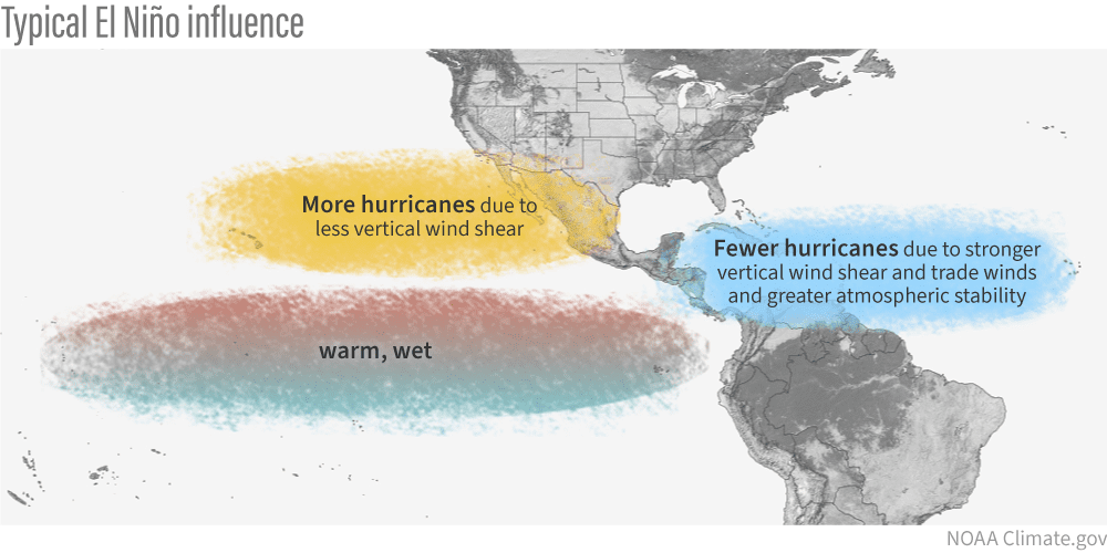
A NOAA Climate.gov graphic shows the typical influence of El Niño, including more favorable hurricane conditions in the eastern Pacific and fewer hurricanes in the Atlantic due to stronger vertical wind shear, stronger trade winds, and greater atmospheric stability. (Photo courtesy NOAA)
DaSilva shared additional details regarding how El Niño affects the weather, including hurricane season.
“El Niño typically leads to fewer storms in the Atlantic, because it increases wind shear, creating hostile upper-level winds that disrupt tropical development. That tends to keep storm numbers lower overall, with more frequent periods of wind shear across the basin. It’s the opposite in the Pacific region, when during El Niño, there is generally less wind shear, which allows for more active hurricane seasons there.”
“Overall, wind shear this season is expected to be higher across the Atlantic, which should limit development for much of the season,” DaSilva predicted. “However, the wind shear will not be constant, and there will still be periods of lower wind shear. Those are the opportunities when powerful storms can form, especially with very warm ocean temperatures. The stronger El Niño becomes, the lower the total number of storms is likely to be. If we reach a very strong “super El Niño,” storm totals would likely fall toward the lower end of the hurricane forecast range,” he said.
Still, DaSilva noted that the northeastern Caribbean should not ignore the season, even if the overall Atlantic number of cyclones could be lower than average.
“I am concerned about the northeastern Caribbean potentially being grazed by a couple of systems this year,” DaSilva stated. “Storm tracks could be similar to last year, where systems approach the region and then turn north and away from the islands. While many storms may recurve, there is still a risk that some could come close enough to bring impacts, especially to the northern and northeastern Caribbean. Even in a quieter season, it only takes one storm. That is why preparation is critical every year, regardless of the forecast,” he warned.
Additionally, DaSilva said a quieter season does not eliminate the risk of a dangerous hurricane.
“Ocean temperatures are expected to be extremely warm, and ocean heat content will be very high, and any storm that finds a pocket of lower wind shear could rapidly intensify,” DaSilva cautioned. “People may see a season with fewer storms and assume there is little to worry about, but that can actually make it more dangerous. People may let their guard down. Even with lower numbers, it only takes one storm in the right conditions to become a high-impact hurricane. That’s why it’s critical to take this season seriously and have a hurricane plan in place. We are particularly concerned about areas along the northern and northeastern Gulf Coast and the Carolina coastline this season,” DaSilva continued.
Residents Should Remain Vigilant
For the U.S. Virgin Islands and Puerto Rico, seasonal outlooks can help describe the larger pattern, but they cannot predict whether any one island will be affected. DaSilva said early-season activity may occur before El Niño fully strengthens.
“There is a possibility of early-season tropical activity, because wind shear may be lower before El Niño fully strengthens, which could allow for some development,” DaSilva explained. “As El Niño builds, wind shear would likely increase, especially later in the season. For the Caribbean, especially the eastern Caribbean, the highest risk typically comes starting in July and increasing into August. Early in the season, it is more common to see tropical waves that have not fully developed yet. If El Niño becomes very strong, especially a super El Niño, wind shear would likely be stronger during the second half of the hurricane season,” DaSilva concluded.
The takeaway for the Virgin Islands remains straightforward: even if El Niño helps reduce the overall number of Atlantic storms, residents and visitors should use the coming weeks to review plans, follow official forecasts, and make sure emergency supplies are ready.
The family of the beloved Andres Avila Esperanza are saddened to announce his passing on April 30, 2026.Andres Avila Esperanza
He is preceded in death by his mother, Ana Esperanza and father, Melchor Avila.
He is survived by his wife, Elizabeth Lopez-Avila; son, Andres Avila lopez; daughters, Hilda Avila, Ada Avila, Lopez; grandchildren, Carlos Gonzales, Ada Monell, Danetlis Rodriguez, Pedro L. Rodriguez, Felipe Monell, Andres J. Avila, Abner J. Avila, Alexander J. Avila, Yamiles Gonzales, Catalina Gonzales, Ethan Avila, Leanetlis J McPhill; brothers, Norberto, Guillermo, Thomas Avila, also Miguel Esperanza; sisters, Alcedia, Lucia, Adela Avila (laly); daughters- and sons-law, Felipe Monell, Mariela Guadalupe-Avila; adopted children, Ramon Batista, Edward Perez, Ruben Velazquez; and special friends too numerous to mention;.
Friends and Family Viewing: Friday May 15 from 5 p.m. to 6 p.m. at Kingshill Funeral Home, 303 Clifton Hill, Kingshill VI 00850
Funeral Service will be held on Saturday, May 16, at Iglesia De Dios Inc. at 159 Estate Profit Hill, Kingshill VI 00850
Viewing 9 a.m.
Services 10 a.m.
Interment at Frederiksted Cemetery.
The Virgin Islands Waste Management Authority advises the public that the fire at the Anguilla Landfill has been contained and the facility has resumed limited operations for commercial haulers.
Virgin Islands Waste Management Authority
To ensure continued safety while crews remain active within the working phase of the landfill, traffic into the facility is currently limited. All haulers and landfill users are asked to exercise caution and follow all instructions provided by on-site personnel.
These temporary operational measures are necessary to support ongoing monitoring and containment efforts within the landfill’s active working area.
VIWMA appreciates the patience, cooperation, and understanding shown by commercial haulers and the community throughout the response and recovery process. The Authority will continue monitoring conditions closely and provide updates should operational changes become necessary.
For more information, please contact the Division of Education and Communications Management at 340-715-9100 or email communications@viwma.org. Stay connected with VIWMA on Facebook, X, and LinkedIn for updates.
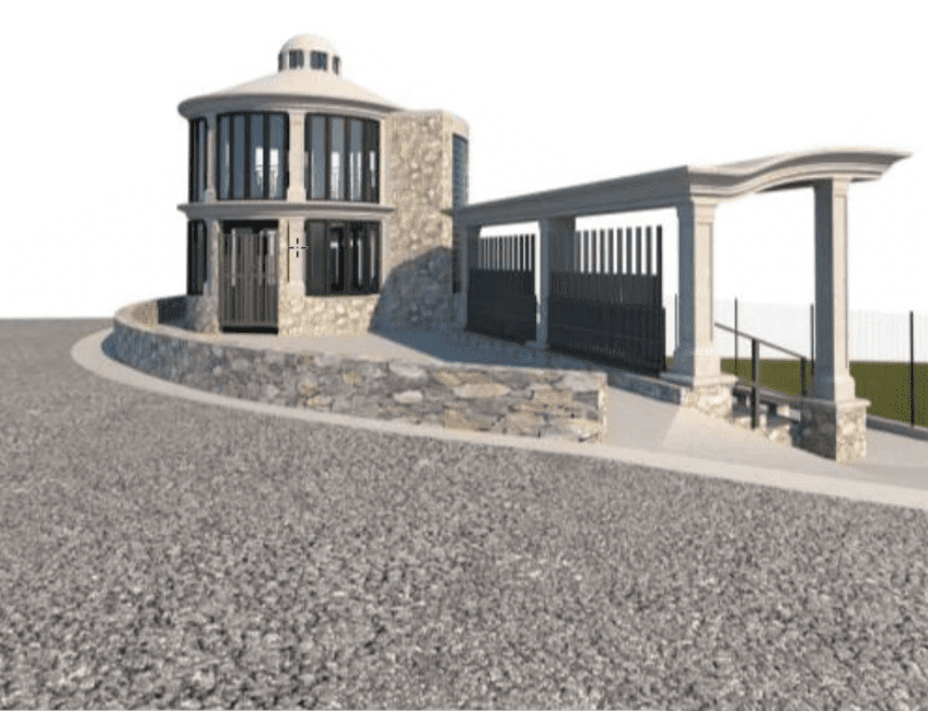
Gazebo- Proposed visual rendition of the press box, concession, and reinforced bleachers at the Winston Wells Ballpark in St. John. (Teams meeting screenshot)
The St. John Coastal Zone Management committee approved the reconstruction of the Cruz Bay firestation and modification of a reverse osmosis plant at the Westin on St. John, while holding a public hearing Wednesday for the demolition and construction of the Winston Wells Ballpark concession kiosk and bleachers.
CZM committee members unanimously voted to approve application No. CZM0046-25 for the reconstruction of the Robert O’Connor Fire Station Reconstruction Project at Estate Enighed in St. John, after hearing updated testimony from presenters. In November 2025, the Virgin Islands Fire and Emergency Services applied for the demolition and reconstruction of the fire station. The new structure will be two stories measuring approximately 9,300 gross square feet and constructed in virtually the same footprint as the existing structure. The existing facility will be demolished prior to the commencement of new construction. A modified floor plan will also accommodate three vehicles, including an ambulance.
Later, the committee heard testimony on application No. CZM0006-26 for the Virgin Islands Department of Sports Parks and Recreation regarding the Winston Wells Ballpark concession kiosk and bleachers’ demolition and construction in Cruz Bay. The modifications aim to restore infrastructure for community activities, including baseball games and events. The project will take one year to complete and entail the construction of a 650 square foot, two-story, circular reinforced concrete gazebo pavilion, a 680 square foot reinforced concrete dual bleacher system, and eight parking spaces. As a result of destruction incurred by the hurricanes in 2017, the facility’s design includes features that can withstand winds of up to 175 miles per hour and will have aluminum bleachers accommodating 64 people.
Some concerns raised by attendees included safe pedestrian access during construction, surveying errors, and coordination with nearby projects (such as the new youth center, fire station development, Port Authority projects, and questions about parking).
“That area is very visibly used by people walking coming from Fish Fry Road and coming up into town,” said committee member Rafe Boulon. “During construction, is there a plan to provide a temporary walkway around that area so that people don’t have to cross and go through the roundabout or something to get down to town?”
Habibah Bell, application presenter for Harnel Engineering and Construction, replied, “What we can do is perhaps create a small walkway between the retaining wall and the roadway. We need at least three and a half feet, four feet would be ideal, and create a walkway around this retaining wall area.”
Additionally, the lack of restroom facilities in the design was also a raised concern.
“These are some of the problems we don’t be thinking of enough because we’re just building things back and don’t be thinking about the future,” said committee chair Andrew Penn. “You need a restroom. If you’re having food there is a water connection,” he added, and questioned the presence of a sewer system to which Bell confirmed there is.
More so, committee member Kurt Marsh asked for clarification on the location of parking spaces.
“I think the greater concern is that you guys are under the impression that you have eight parking spots across the street when based on what we just observed from the Fire Services presentation, you don’t because they are using that space.”
Roy Canton, disaster specialist with the Office of Disaster Recovery and Sports, Parks, and Recreation, responded that the area in question is surveyed for the SPR department but has parking spaces that the department allows the fire department to use.
“For the fire station to essentially claim those spots, without any formal maybe written or some kind of agreement from Sports, Parks, and Recreation, well, how would they know,” responded Bell. “So the fire station may need to find parking for their facility.”
“Right, but the issue is they’re not using it for parking, their building footprint is occupying some of that space,” replied Marsh.
The committee encouraged members for the SPR department to work out the parking space concerns with the fire department.
Members also unanimously voted to approve application No. CZMO-MJ0001-26 for the modification of the reverse osmosis plant at the Westin St. John Resort. The project proposes to install a new larger reverse osmosis plant due to the hotel’s water demands. A new building will be constructed to house the new plant and a new larger diameter seawater intake line will be installed, increasing it from eight inches to twelve inches in diameter.
“The existing plant is coming to the end of its life right now,” said presenter Miguel Arana, who added that the replacement parts are hard to find or obsolete. “It will give a greater treatment capacity of water and water storage as well.”
The drainageway will also be updated to avoid erosion. Instead of curving across the beach, “We’re going to excavate, take the line under the gut, and then come out at a straight line off across the beach, bearing the line. That way we won’t have the same erosion problems,” said Amy Dempsey, Bio Impact’s representative.
One property owner, David Gloski, inquired about the plume or emission from the pipes that will be constructed in the seabed. Dempsey responded that “It doesn’t have chemicals in it. All they’re doing is taking whatever’s in the water, they’re just concentrating it. There’s not things added to it.”
Members Andrew Penn, Refe Bouyon, Elissa Runyon, and Kurt Marsh were present and voted.
The Virgin Islands Department of Education advises the public that Eulalie Rivera PreK-8 School will dismiss early today due to a broken sewage pipe on the campus.
Eulalie Rivera K-8 School on St. Croix. (V.I. Education Department photo)
Out of an abundance of caution and in prioritizing the health, safety, and well-being of our students, faculty, and staff, early dismissal will take place at 1:30 p.m. Students who utilize school bus services will be provided with transportation.
The Bureau of School Construction and Maintenance is actively working to address the issue and will continue to work on it throughout the day. We appreciate the cooperation and understanding of parents, guardians, and the community as we work to ensure a safe school environment.
For updates, please continue to follow the Virgin Islands Department of Education’s official communication platforms.
Commissioner Jean-Pierre L. Oriol of the Department of Planning and Natural Resources announces the launch of a new Life Jacket Loaner Program through the Division of Fish and Wildlife, aimed at increasing access to safe recreational boating throughout the U.S. Virgin Islands.
Borrow a life jacket from DPNR. (Submitted photo)
In observance of National Boating Safety Week, DFW is introducing the program to help both adults and children participate in boating activities who may not otherwise have access to a life jacket. Beginning May 18, individuals 18 years of age and older may visit any DFW or Division of Environmental Enforcement office in the territory to sign out an adult- or child-sized life jacket for day use.
“Life jackets are not only required by law, but they are also critical to protecting boaters while enjoying the waters of our territory,” said Commissioner Oriol. “We are pleased to offer this program to ensure that everyone has the opportunity to boat safely, even if they do not own a life jacket.”
The Division of Fish and Wildlife encourages all residents and visitors to exercise caution and prioritize safety while on the water.
For more information about the Life Jacket Loaner Program, please contact the Division of Fish and Wildlife at 340-773-1082 on St. Croix or visit the DPNR website at https://www.dpnr.vi.gov.
The Department of Public Works advises the community that payment operations at the Fort Christian Parking Lot will resume on Monday, May 18.
All vehicles currently in the lot must be removed to allow for scheduled cleanup and maintenance on Saturday, May 16, and Sunday, May 17. Vehicles remaining in the lot during that time will be towed at the owner’s expense.
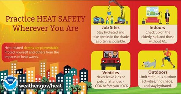
A Heat Advisory will be in effect from 11 a.m. to 4 p.m. AST for areas across Puerto Rico and the U.S. Virgin Islands. Additional heat alerts may be issued in the coming days. (Photo courtesy NWS, San Juan, Puerto Rico)
A Heat Advisory will be in effect across the U.S. Virgin Islands and Puerto Rico on Thursday as hot weather affects the region. Additionally, marine conditions will be choppy and passing showers are possible, according to the National Weather Service in San Juan.
Heat Advisory Issued
The Heat Advisory, issued by the NWS, will be in effect from 11 a.m. to 4 p.m. AST Thursday for the U.S. Virgin Islands and portions of Puerto Rico, according to an update from the NWS on Thursday morning. The excessive heat is expected to continue over the coming days, and additional heat alerts could be issued.
“Dangerous heat conditions will continue through the weekend across urban and coastal areas of Puerto Rico and the U.S. Virgin Islands, with heat indices exceeding 100°F at times. Additional Heat Advisories may be required,” the NWS said.
“Heat indices are expected to reach values up to 111°F in urban and coastal areas,” the NWS added.
The NWS explained that a Heat Advisory “means that temperatures of at least 100°F or heat index values of at least 105°F are expected generally within the next 24 hours.”
The NWS defines the heat index, also known as the apparent temperature, as “what the temperature feels like to the human body when relative humidity is combined with the air temperature.”
Residents and visitors are encouraged to stay hydrated, limit strenuous outdoor activity during the hottest part of the day, and check on vulnerable individuals, including children, older adults, outdoor workers, pets, and people without access to adequate cooling.
“These conditions can be dangerous, particularly for people sensitive to heat, those without adequate hydration or cooling, outdoor workers, and vulnerable populations,” the NWS warned. “Heat stress may also impact some healthcare systems and heat-sensitive industries.”
The National Weather Service in San Juan warns of life-threatening rip currents along north- and east-facing beaches in Puerto Rico and the U.S. Virgin Islands. (Photo courtesy NWS, San Juan, Puerto Rico)
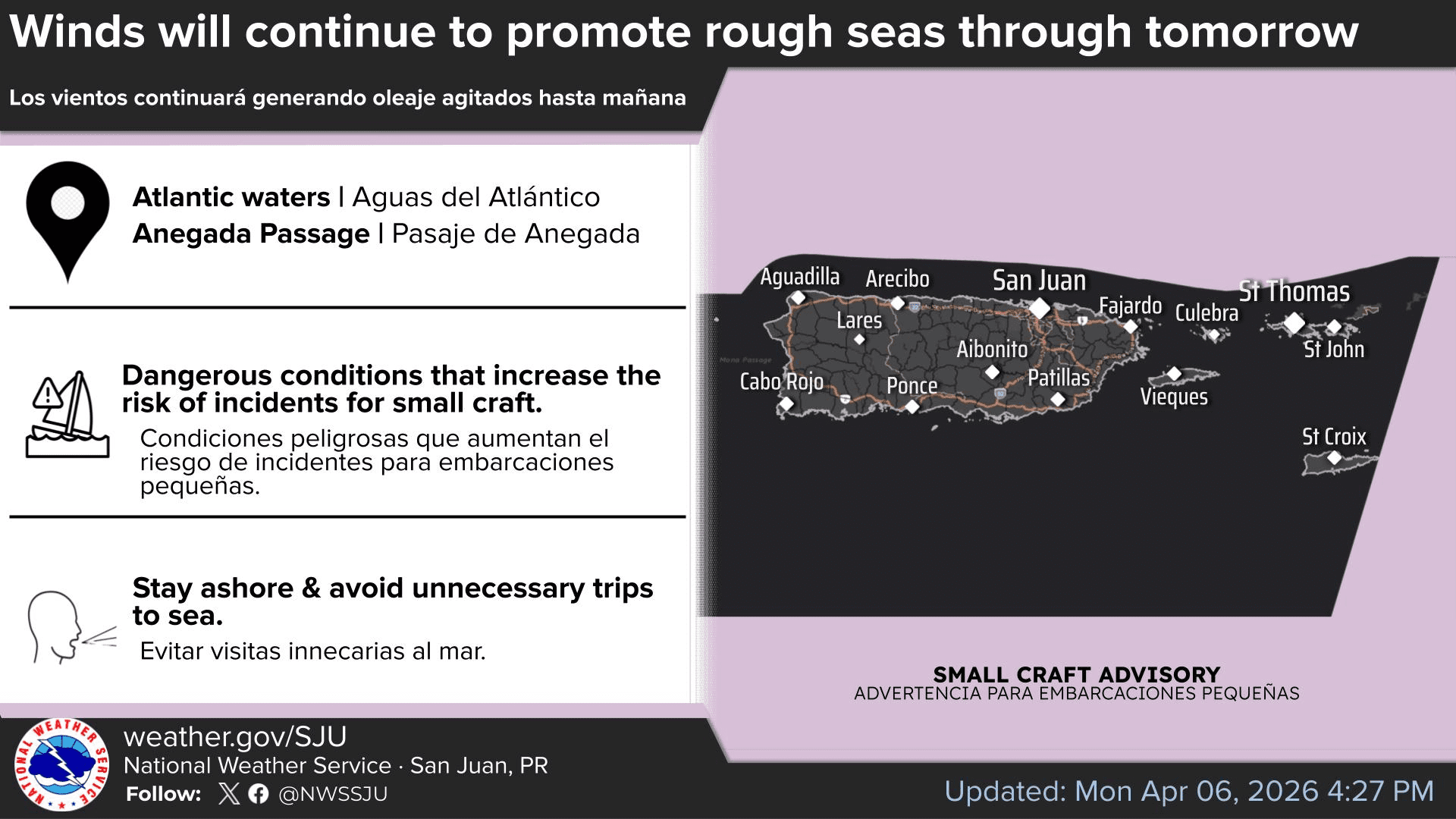
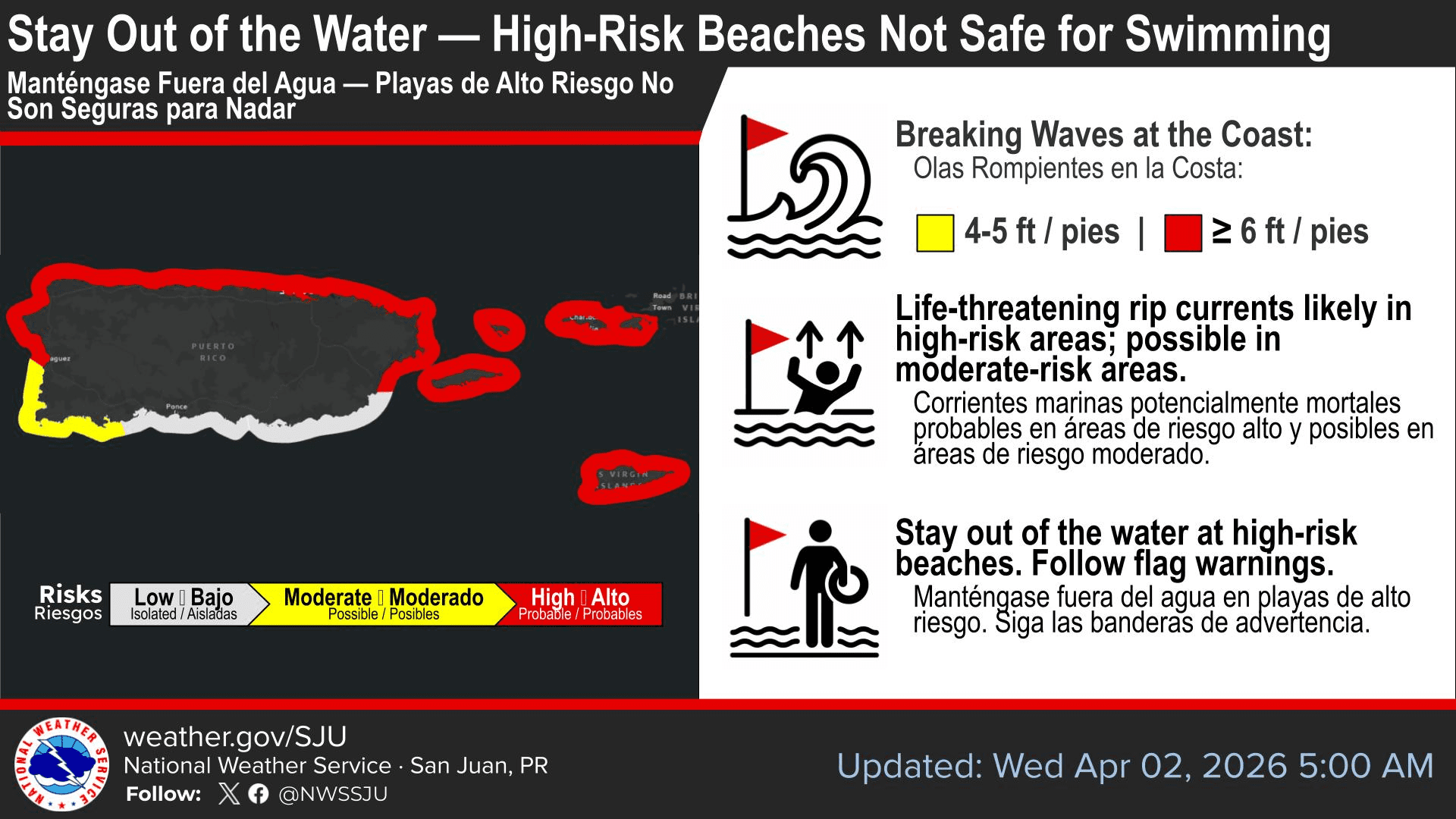
Marine Conditions
Marine conditions will remain somewhat choppy due to breezy east to east-southeasterly winds across the regional waters. A high risk of rip currents is in effect for the U.S. Virgin Islands until 6 a.m. on Friday.
“A northeasterly swell combined with locally generated wind waves will maintain a high risk of dangerous rip currents along portions of the north- and east-facing beaches of Puerto Rico and the US Virgin Islands,” the NWS stated.
Residents and visitors are encouraged to practice heat safety by staying hydrated, limiting outdoor activity, checking on vulnerable individuals and never leaving children or pets unattended in vehicles. (Photo courtesy NOAA)
Unsettled Weather Possible
Regarding rainfall chances, the NWS reported that passing showers are expected at times, especially across windward areas during the overnight and morning hours. The NWS said that ponding of water on roads, reduced visibility, and isolated urban and small stream flooding will be possible. Additional unsettled weather could arrive by next week as an area of low-pressure arrives near the islands.
“A wetter and slightly more unstable weather pattern may develop early next week as an upper-level trough approaches the region, increasing the potential for more frequent showers and isolated thunderstorms,” the NWS stated.
Finally, minor amounts of Saharan dust are also expected to affect the region.
“Traces of Saharan dust particles are expected between Friday and Saturday. Although the highest concentrations should remain south of the islands, hazy skies and minor air quality reductions will still be possible,” the NWS explained.
The morning sun shines over Christiansted Harbor, St. Croix, on Thursday, as hot temperatures affect the U.S. Virgin Islands. (Source photo by Jesse Daley)
Local Weather Forecast Information
Information regarding the weather across the USVI, including marine forecasts, is available from the NWS and NOAA. With the Atlantic hurricane season set to begin June 1, individuals across the islands are also encouraged to begin preparing for hurricane season.