

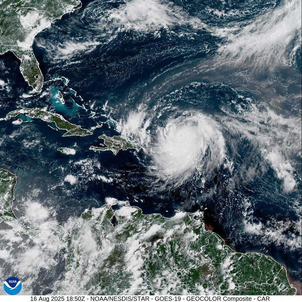
Hurricane Erin rapidly intensified into a Category 5 storm Saturday as its core passed just north of the U.S. Virgin Islands and Puerto Rico. The National Hurricane Center warned that heavy rain, gusty winds, and dangerous surf will affect the region through the weekend, with multiple weather alerts in place.
After initially struggling to organize earlier this week, Erin underwent rapid intensification, surging from a Category 1 hurricane at 11 a.m. Friday to a Category 5 monster in just 24 hours. The NHC noted that Erin’s intensity may shift over the coming days as the storm undergoes inner-core changes and possible eyewall replacement cycles.
Track of Hurricane Erin
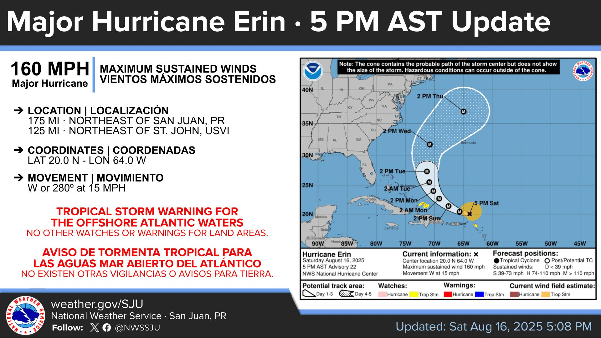
As of the 5 p.m. Saturday update from the NHC, Hurricane Erin was located about 175 miles northeast of San Juan, Puerto Rico, moving west with maximum sustained winds of 160 mph. The storm’s minimum central pressure was measured at 915 millibars, underscoring its power.

“At 5:00 p.m. AST, the center of Hurricane Erin was located near latitude 20.0 North, longitude 64.0 West. Erin is moving toward the west near 15 mph, and this motion is expected to continue Saturday evening,” according to the NHC.
Forecasters said Erin is expected to slow down and shift to a west-northwest track later on Saturday night, then turn north early next week.
“On the forecast track, the center of Erin is expected to move just north of the northern Leeward Islands, the Virgin Islands, and Puerto Rico through Sunday and pass to the east of the Turks and Caicos Islands and the southeastern Bahamas Sunday night and Monday,” the NHC said.
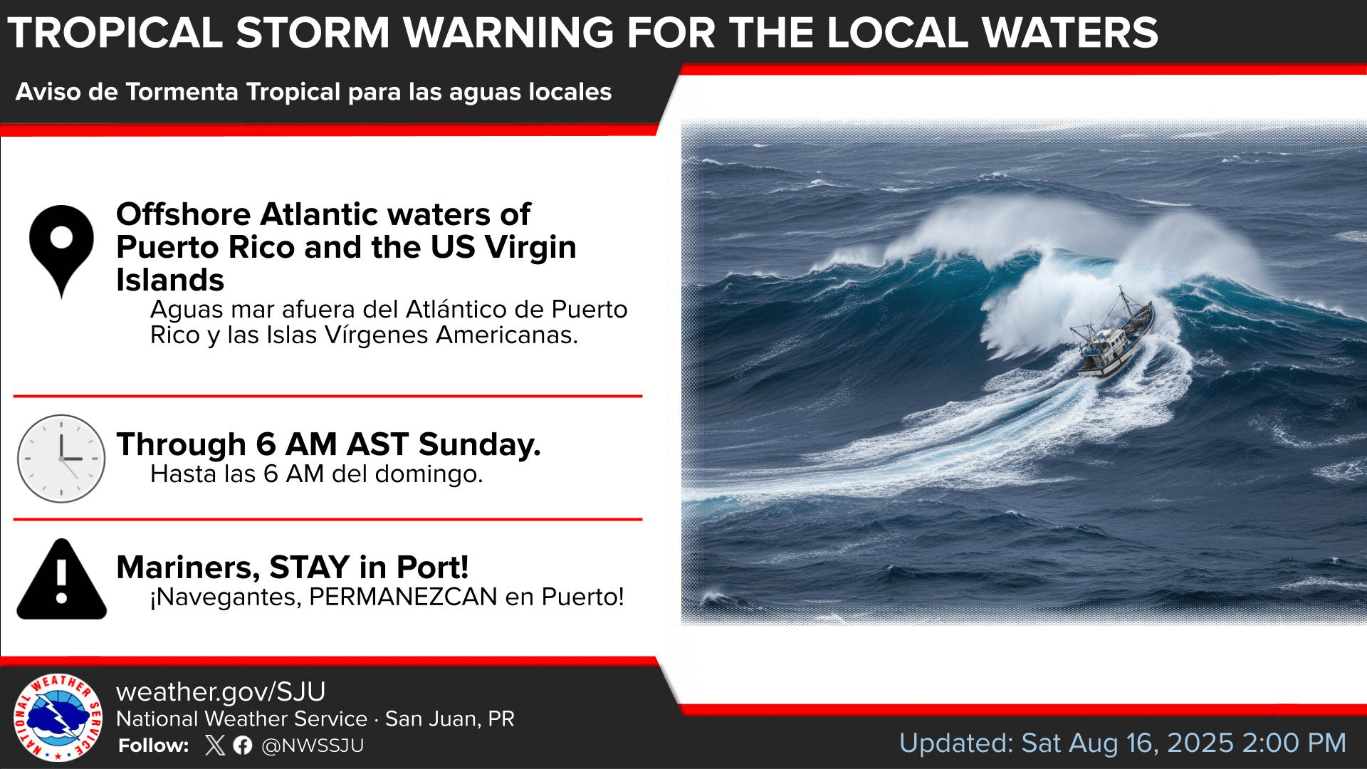
Earlier on Saturday, during the 11 a.m. update from the NHC, the agency explained that the track of Erin had shifted slightly west and south, and a Tropical Storm Warning was issued for the Atlantic waters north of Puerto Rico and the USVI from 10 nautical miles offshore up to 19.5 N latitude until 6 a.m. on Sunday.
No tropical storm or hurricane watches or warnings were in effect for the land areas across the U.S. Virgin Islands, the British Virgin Islands or Puerto Rico as of 5 p.m. Saturday. However, a Tropical Storm Watch was posted for nearby islands including St. Martin, St. Barthelemy, Sint Maarten, and the Turks and Caicos.
According to information from the NHC, a Tropical Storm Watch means tropical storm conditions with winds of 39 to 73 mph are possible within 48 hours, while a Tropical Storm Warning means those conditions are expected within 36 hours. A Hurricane Watch signals hurricane conditions with winds of 74 mph or higher are possible within 48 hours, and a Hurricane Warning means those conditions are expected within 36 hours.
Severe Weather Alerts in Effect for USVI, Puerto Rico
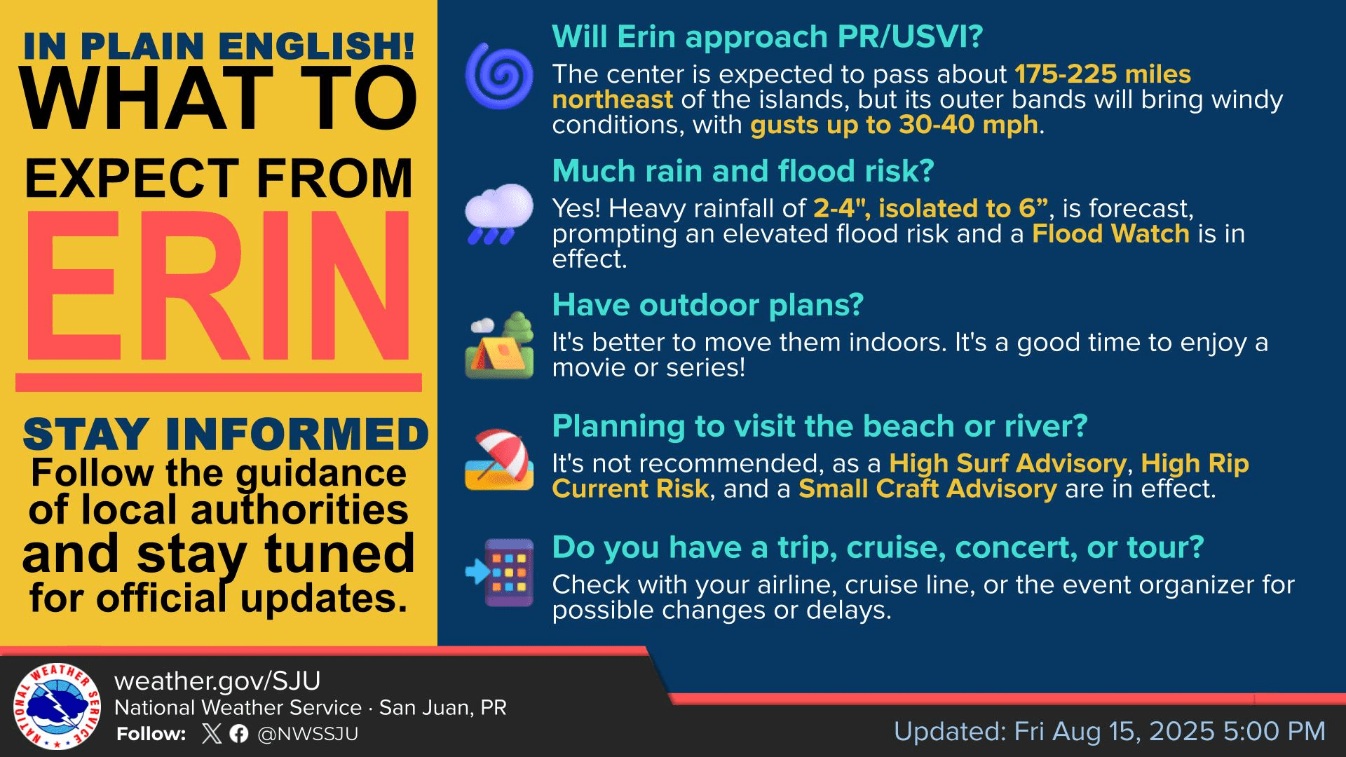
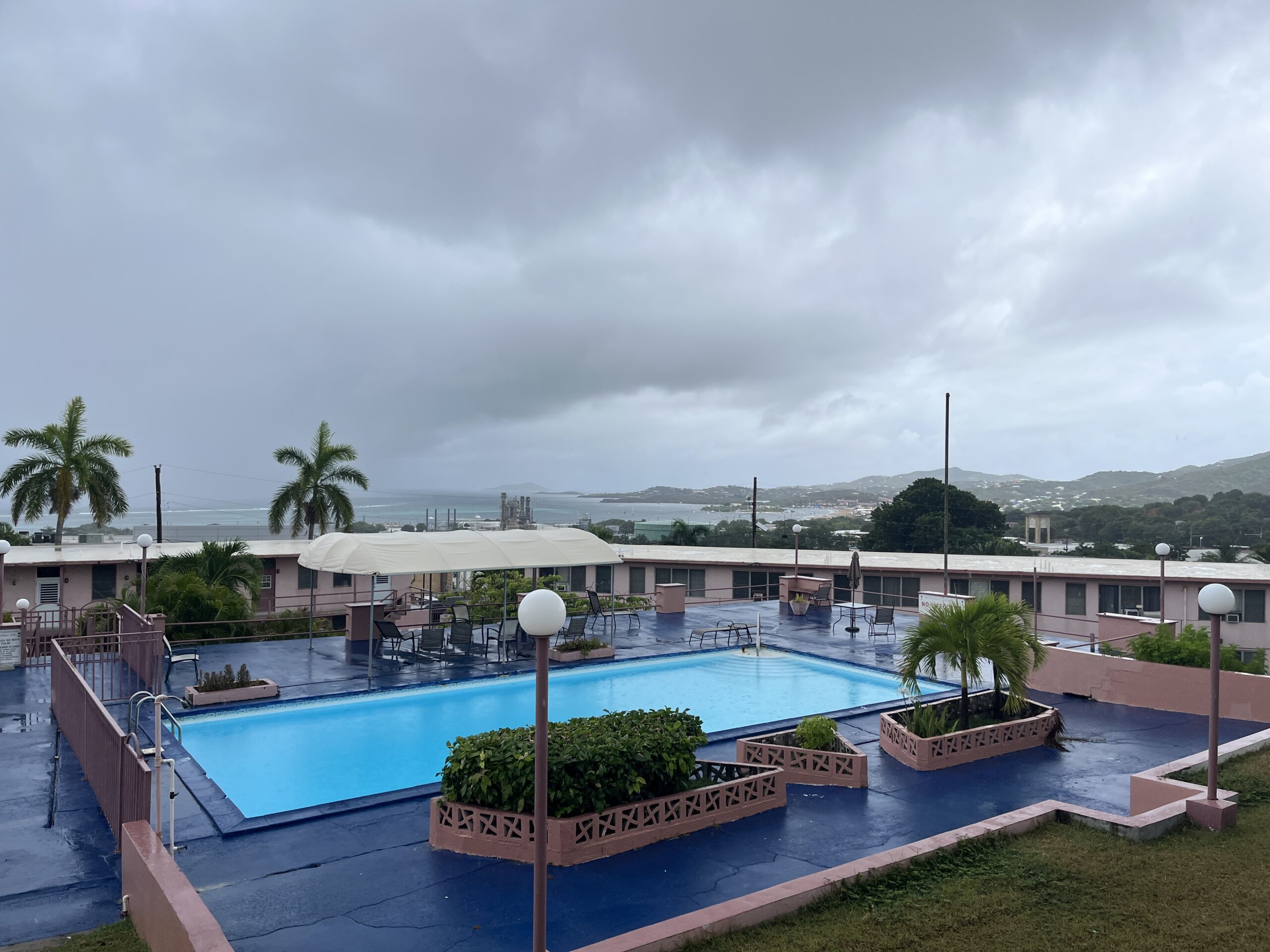
While the core of the cyclone continues to pass just north of the U.S. Virgin Islands and Puerto Rico, areas across the islands had received rainfall, gusty winds and powerful ocean swells.
“As of 2 p.m. on Saturday, rainbands associated with Hurricane Erin left in general between one and two inches of rainfall across portions of northwestern and eastern Puerto Rico, and up to three quarters of an inch in the northern U.S. Virgin Islands,” according to information from the NWS in San Juan, Puerto Rico. “Maximum wind gusts reported so far were up to 29 mph in St. Thomas,” the NWS reported.
Additionally, at 3:11 p.m. AST Saturday, a Flash Flood Warning was issued for St. Thomas and St. John, due to heavy rainfall over the islands. At 3:38 p.m. AST, a Special Marine Warning was also issued for the waters surrounding the USVI and Puerto Rico, as powerful thunderstorms capable of producing strong winds and waterspouts moved through the area.
Other severe weather alerts are also in effect for the USVI and Puerto Rico, including a Flood Watch, High Surf Advisory, High Rip Current Risk, and Small Craft Advisory. These alerts went into effect on Saturday and will remain in place through at least Monday.
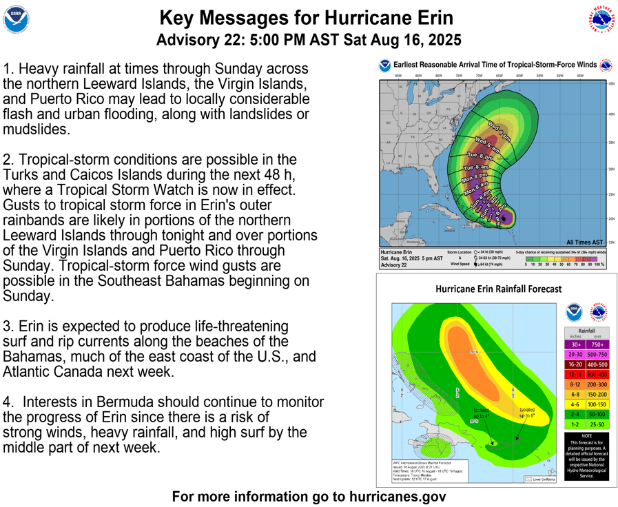
“The outer bands of Erin will continue to produce areas of heavy rainfall through Sunday across the northern Leeward Islands, the Virgin Islands, and Puerto Rico. Rainfall totals of two to four inches, with isolated totals of six inches, are expected,” the NHC said. “Locally considerable flash and urban flooding, along with landslides or mudslides, are possible,” the NHC continued.
“Tropical storm conditions are possible within the watch area in the Leeward Islands tonight, and in the watch area in the Turks and Caicos Islands beginning on Sunday,” the NHC stated. “Squalls with wind gusts to tropical-storm force may occur elsewhere over portions of the northern Leeward Islands, Virgin Islands, and Puerto Rico through Sunday. Squalls with wind gusts to tropical-storm force may also occur over the southeastern Bahamas beginning on Sunday,” the NHC added.
“Swells generated by Erin will affect portions of the northern Leeward Islands, the Virgin Islands, Puerto Rico, Hispaniola, and the Turks and Caicos Islands through the weekend. These swells will spread to the Bahamas, Bermuda, and the east coast of the United States by early next week,” the NHC noted.
National Weather Service Information
The National Weather Service in San Juan, Puerto Rico, shared the following information on Saturday regarding continuing impacts from Erin.
“The rainbands of Hurricane Erin will bring showers and thunderstorms, producing periods of moderate to locally heavy rain and gusty winds across the US Virgin Islands and Puerto Rico through the rest of the weekend,” the NWS warned. “The unsettled weather pattern will continue to create the risk of urban, river, and flash flooding, as well as isolated landslides across Puerto Rico and the U.S. Virgin Islands.”
The NWS also urged caution regarding hazardous marine conditions, noting that wave heights could reach between seven to 10 feet or even higher.
“Swells from Erin will deteriorate seas across the Atlantic waters and Caribbean passages through late Sunday,” the NWS said. In addition, dangerous swimming conditions, life-threating rip currents, and rough surf conditions will persist across the west, north, and east facing beaches of the islands through the rest of the weekend,” the NWS continued.
“West to northwest winds today will shift from the south to southwest on Sunday and Monday, promoting hot temperatures across the northern and western portions of Puerto Rico,” the NWS added.
U.S. Coast Guard Port Status
On Friday, Daryl Jaschen, director of the Virgin Islands Territorial Emergency Management Agency, held a press briefing on Hurricane Erin.
Regarding the status of ports across the territory, Jaschen noted on Friday that the U.S. Coast Guard would set “Port Condition Yankee” for St. Thomas and St. John, while St. Croix ports will remain at “Port Condition X-Ray.”
On Saturday morning, Jaschen confirmed to the Source that there had not been changes to the port conditions.
According to information available online, Port Condition X-Ray indicates that gale-force winds are expected within 48 hours, while Port Condition Yankee is set when gale-force winds are predicted within 24 hours.
Jaschen encouraged residents to sign up for VITEMA’s emergency notifications in the event that storm-related alerts are announced through the weekend.
Local Weather Updates
It is crucial to remember that the forecast can change very quickly. USVI residents and visitors are encouraged to continue to remain prepared. Weather information is available from the NWS, the NHC, and NOAA.
The local weather forecast for the U.S. Virgin Islands is regularly updated on the Source Weather Page and VI Source YouTube Channel. A weekly Tropical Outlook article from the Source is also published throughout hurricane season to provide in-depth updates.
Additionally, residents and visitors can find weather details and preparedness information from VITEMA.


