

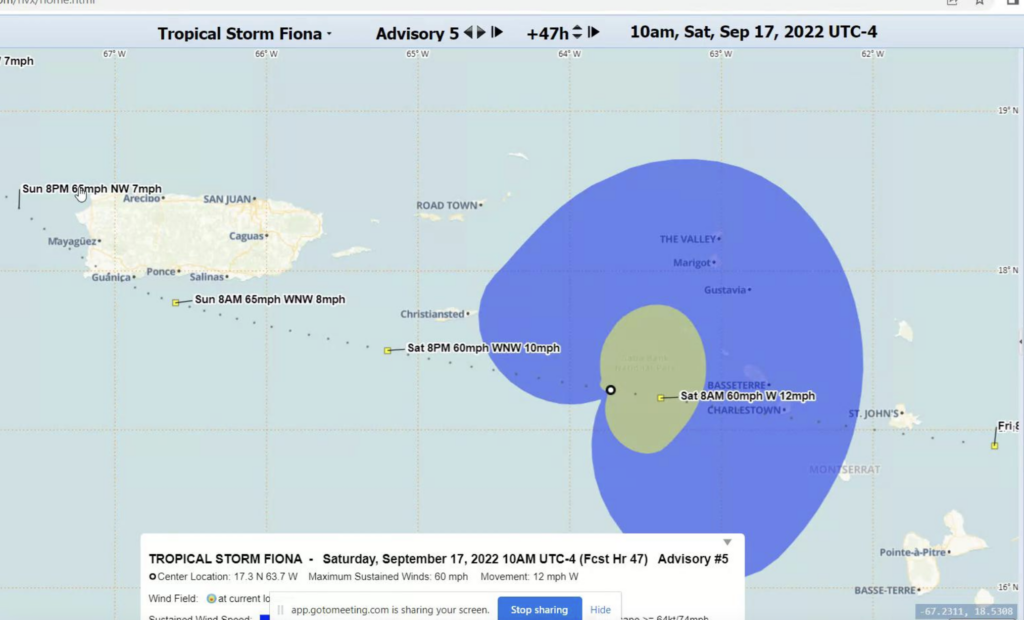
Tropical Storm Fiona is on track to pass just south of St. Croix on Saturday, bringing winds of 60 to 65 mph and heavy rain, according to meteorologists at the National Weather Service in San Juan, Puerto Rico.
Originally expected to start impacting the U.S. Virgin Islands on Friday night, the forecast has changed slightly as Fiona is predicted to slow as it enters the Caribbean Basin on a westerly track, meteorologist Emanuel Rodriguez said Thursday afternoon during a webinar briefing for emergency management officials and the media.
Rodriguez also warned that at two days out, the track could still change, with the possibility that Fiona could instead pass north of St. Croix, and residents of all the islands should prepare accordingly. The error factor can be as much as 120 miles, he said.
“We have high confidence that the high pressure to the north will maintain that westward movement during the next 24 to 36 hours,” said Rodriguez.

“We know that we are very small islands here, so any slight change in the track will change the forecast. But we have good consistency in the forecast in the last 24 hours, so hopefully we stay the same during the next 48 hours,” said Rodriguez. “But be prepared to see some slight change. Instead of passing a few miles south of St. Croix, it could be passing between St. Croix and St. Thomas and St. John,” he said.
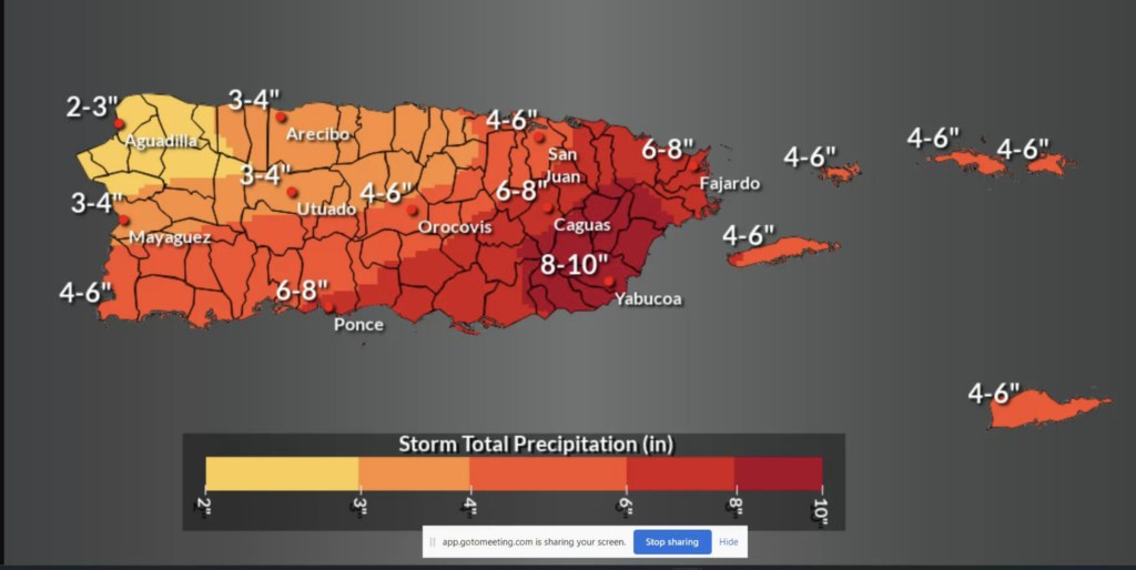
Whatever the track, the experts are certain that Fiona will be a rainmaker. Originally forecast to bring 2 to 4 inches of rain to the U.S. Virgin Islands, the storm is now expected to dump 4 to 6 inches as it slows its forward trajectory, said Rodriguez.
“We may see showers lingering Sunday night into Monday, associated with the tail [of the storm], specifically in the Virgin Islands and eastern Puerto Rico,” he said.
The U.S. Virgin Islands should expect to feel the first outer bands of the storm starting around 10 a.m. Saturday, with the closest approach to St. Croix on Saturday afternoon, he said.
While additional strengthening is not expected as a westerly shear is keeping the storm from further organizing, the forecasters warned that residents shouldn’t let their guard down.
Hurricane Hunters were investigating Fiona Thursday afternoon, and the National Weather Service expected to issue an update Thursday evening based on their findings, said meteorologist Ernesto Rodriguez.
Fiona is approaching on the anniversary of Hurricane Marilyn, which came off the coast of Africa on Sept. 7, 1995, became a tropical depression on Sept. 12, then rapidly intensified into a Category 3 storm after entering the Caribbean Basin, pummeling the U.S. Virgin Islands on Sept. 15.
However, Emanuel Rodriguez said meteorologists are “definitely not expecting” Fiona to be a repeat of Marilyn. “Sixty-five miles per hour is a reasonable estimate of what to expect with this storm,” he said.
The chances of intensification into a hurricane are less than 5 percent, he said.
“Looking at the system, as of now we don’t see a lot of intensification going on because the center is exposed. The center is away from the main area of showers and thunderstorms. Hopefully, it stays the same or reduces intensity as it moves through our region, but as of now the system is struggling a bit to maintain that heavy shower and thunderstorm activity near the center,” said Emanuel Rodriguez.
A Tropical Storm Watch may be issued for the islands on Thursday at 11 p.m., depending on what Hurricane Hunters discover during their investigation, he said.
“The weekend will be wet and windy. Make sure you finish your preparations today.”


