
The National Weather Service in San Juan, Puerto Rico, expects an unstable weather pattern across the region through early this week, warning of periods of rainfall and thunderstorms, with an elevated risk of flooding. Additionally, marine conditions will be hazardous due to ocean swells and gusty winds.
Rainfall and an Elevated Flood Risk
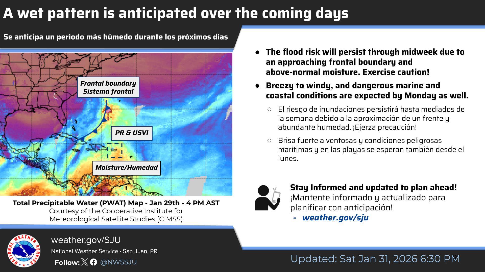
On Sunday, the NWS explained that atmospheric factors will influence the anticipated wet weather pattern.
“A wet and unsettled weather pattern is anticipated across the region for the next few days,” the NWS reported on Sunday morning.
“This weather pattern is influenced by an approaching frontal boundary to the northwest, associated with an upper-level polar trough of low pressure and a mid-to-upper-level ridge of high pressure to the east of the islands. This setup is promoting a southerly low-level wind flow and enhanced moisture being lifted from the Caribbean Sea,” the NWS explained.
“Due to this atmospheric instability, periods of moderate to heavy rainfall and isolated thunderstorms are expected to persist through midweek,” the NWS added.
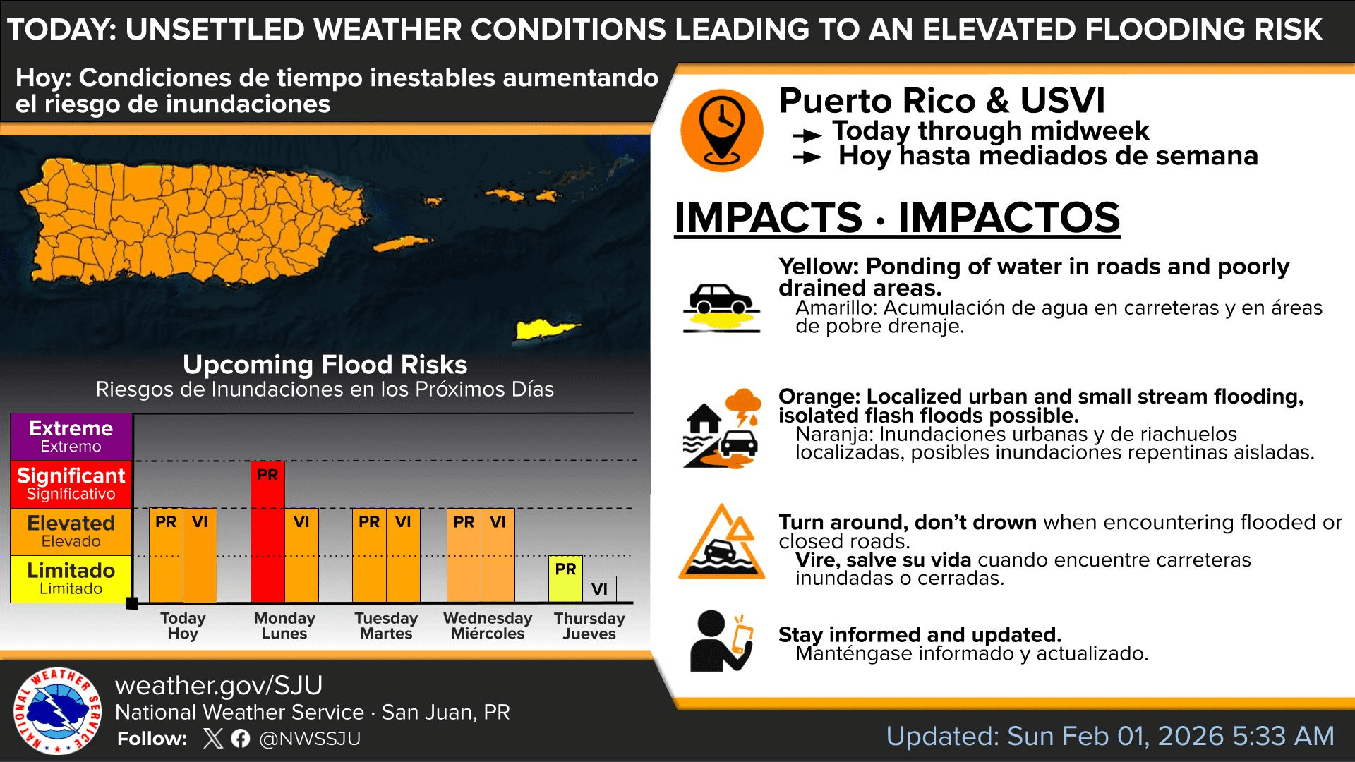
The NWS noted that areas of Puerto Rico could experience the most significant amounts of precipitation, but the U.S. Virgin Islands will also see rainfall, especially on Monday and Tuesday. Forecasters also warned that the risk of flooding will increase due to the potential for rainfall this week.
“An elevated flood threat will persist through midweek. Urban and small stream flooding, localized flash flooding, and minor landslides in areas of steep terrain are possible, particularly from late Sunday through Tuesday. Residents and visitors are urged to avoid small streams, creeks, and other recreational areas near rivers,” the NWS advised.
Hazardous Marine Conditions
In addition to the expected rainy weather, marine conditions are expected to deteriorate as a powerful long-period swell reaches the regional waters and combines with strengthening winds.
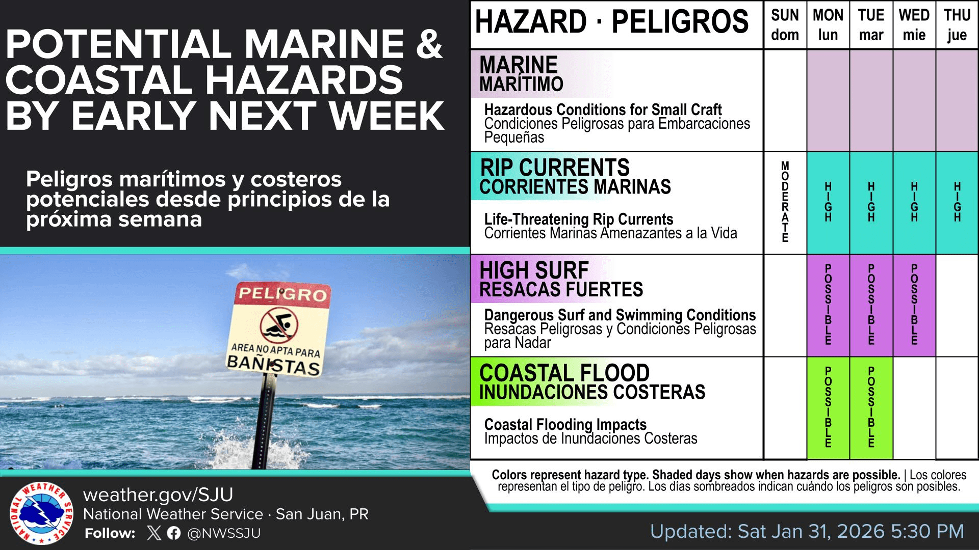
The NWS reported that seas could build to 8-12 feet, and a Small Craft Advisory is expected to be in effect across parts of the regional waters starting Monday morning and continuing into Thursday. A high risk of rip currents is also expected, and some coastal flooding is possible along vulnerable coastal locations.
“Beginning Monday, a long-period northerly to north-northwesterly swell is forecast to arrive and persist through the workweek,” the NWS said. “This swell is expected to bring rough surf and life-threatening rip currents, while also increasing the potential for high surf and minor coastal flooding, particularly during the peak of the event from Monday into Tuesday across exposed Atlantic and northwestern coastlines. Beachgoers are urged to continue monitoring future forecasts as conditions evolve.”
Watching the Local Weather
Local weather information, including marine weather conditions, is available from the NWS, the NHC, and the National Oceanic and Atmospheric Administration. Additionally, the local weather forecast for the U.S. Virgin Islands is regularly updated on the Source Weather Page. Residents and visitors can also find weather alerts and preparedness information from the Virgin Islands Territorial Emergency Management Agency.
Finally, travelers are encouraged to keep an eye on conditions across the U.S. mainland, where the NOAA’s Weather Prediction Center is tracking significant winter weather impacts and prolonged cold that could contribute to airline delays and broader travel disruptions.


