

Warm temperatures, Saharan dust, and breezy conditions are expected across the U.S. Virgin Islands and Puerto Rico, as residents and visitors head into the Emancipation Day and Independence Day holiday weekend, according to the National Weather Service in San Juan.
Hot and Hazy Conditions
According to an update from the NWS on Thursday morning, the NWS expects a gradual increase in Saharan dust in the coming days, leading to a hazy sky, and heat will remain a primary concern across the islands. Gusty winds will also affect the islands.
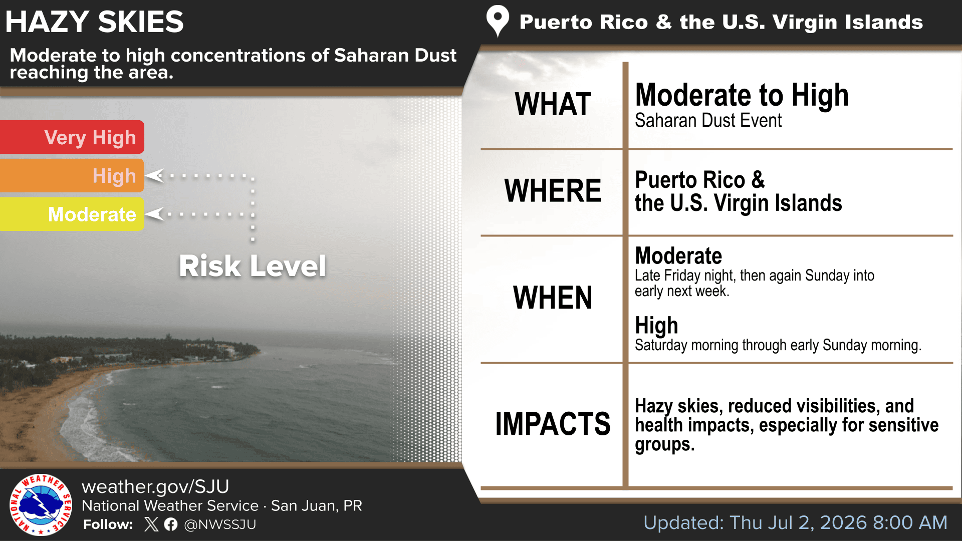
“Warm to hot conditions will continue through the next several days, with the heat index reaching or exceeding 100 degrees Fahrenheit across urban and low-lying areas of the islands,” the NWS said.

“Low concentrations of Saharan dust will persist through early Friday before increasing again for the 4th of July holiday,” the NWS stated.
In addition to hazy conditions, the dust may contribute to reduced air quality, especially for sensitive groups, including people with respiratory conditions, older adults, and young children.
Limited Rain for the USVI
Precipitation chances are expected to remain limited across the U.S. Virgin Islands and eastern Puerto Rico, with only brief passing showers possible at times. The NWS noted that the heaviest rainfall activity is expected to favor portions of Puerto Rico rather than the USVI.
“Eastern Puerto Rico and the U.S. Virgin Islands are expected to receive little more than isolated passing showers,” the NWS explained.
However, across Western and northwestern Puerto Rico, afternoon rainfall could lead to ponding of water on roads, urban flooding, and isolated small-stream flooding.
Marine and Beach Conditions
Marine conditions are expected to become somewhat breezier over the holiday weekend, with seas gradually building. There will be an elevated rip current risk across portions of Puerto Rico and the U.S. Virgin Islands.
“Winds are expected to increase over the weekend accompanied by building seas. As a result, the risk of rip currents is expected to increase to moderate along most beaches across the islands,” the NWS reported.
The NWS added that choppy seas are forecast, particularly off areas of the coast of Puerto Rico.
“Seas will remain generally moderate, with locally choppy conditions at times. Isolated afternoon thunderstorms may develop over the northwestern coastal waters of Puerto Rico,” the NWS said.
Next Week’s Forecast
The NWS noted that the hazy and hot weather pattern may continue into early next week, though moisture could increase by Tuesday and Wednesday as a tropical wave approaches the region. The NWS said this could bring a better chance for showers and thunderstorms.
“By late Tuesday and Wednesday, a tropical wave is expected to bring another surge of tropical moisture which, along with favorable upper-level dynamics, will increase widespread showers and isolated thunderstorms. This can result in localized ponding of water on roads and in poor drainage areas,” the NWS stated.
Tropics: Atlantic Basin Quiet, Tropical Storm Douglas Active in Pacific
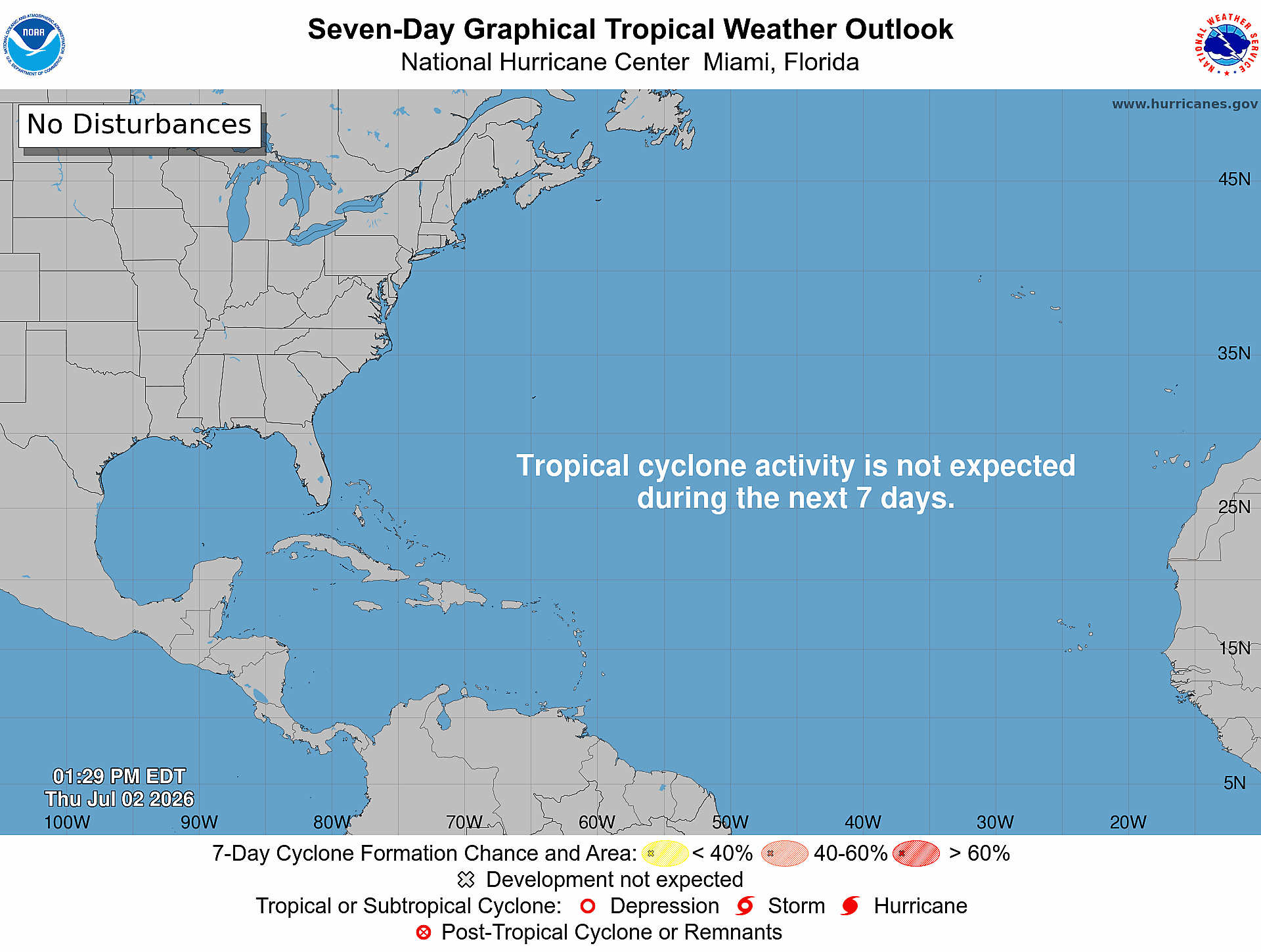
Regarding the tropical update, the Atlantic basin remains quiet for now. According to the National Hurricane Center, as of Thursday, tropical cyclone formation is not expected across the Atlantic basin over the next seven days.
In the eastern Pacific, the NHC was issuing advisories Thursday on Tropical Storm Douglas, located far from land well west-southwest of the southern tip of Baja California. No additional tropical cyclone development is expected across the eastern or central Pacific over the next seven days.
NOAA’s Global Tropics Hazards Outlook, released Tuesday, June 30, also points to a quieter pattern across the Atlantic basin during the coming weeks. The outlook, which is issued each Tuesday by NOAA’s Climate Prediction Center, provides guidance on potential tropical activity across global basins up to three weeks in advance.
The CPC said conditions continue to favor more tropical activity across portions of the Pacific while limiting development potential in the Atlantic.
“The remainder of the Atlantic Basin is forecast to remain exceptionally quiet. High wind shear will limit tropical cyclone development potential and elevate probabilities for below-normal rainfall extending across the Main Development Region into the Caribbean,” the CPC stated.
To date, during this Atlantic hurricane season only one named system, Tropical Storm Arthur, has formed. As forecasters have predicted for months, a strengthening El Niño pattern is expected to help limit tropical cyclone development across the Atlantic basin.
Local Updates
Currently, there are no immediate tropical cyclone threats to Puerto Rico or the U.S. Virgin Islands. Residents are encouraged to follow the local forecasts, especially as dry conditions, Saharan dust, gusty winds, and limited rain chances remain part of the weather pattern. Heat alerts may be issued across both U.S. territories as temperatures remain high.
Information regarding the weather across the USVI is available from the NWS, the NHC, and NOAA. Additionally, the local forecast is regularly updated on the Source Weather Page, and a weekly video forecast is available. Residents and visitors can view weather alerts and disaster preparedness information from VITEMA.


