
As hurricane season draws to a close, let’s examine another powerful visitor to the Virgin Islands: earthquakes. Earthquakes are common around the Virgin Islands and across the Caribbean region throughout the year. A powerful quake that recently struck near Cuba reminds residents and visitors in the Virgin Islands about the importance of earthquake safety.
The Source previously reported information about Caribbean earthquakes in an interview with Elizabeth Vanacore, PhD, a seismologist and a researcher at the Puerto Rico Seismic Network (PRSN). The PRSN, which also operates under its Spanish name, Red Sísmica de Puerto Rico, is affiliated with the University of Puerto Rico Mayagüez Department of Geology. Based in the city of Mayagüez on the west coast of Puerto Rico, the organization constantly monitors the Virgin Islands and Puerto Rico to help keep Virgin Islanders safe and informed about earthquakes and potential tsunami waves.
After a magnitude 6.8 quake rocked the island of Cuba on Nov. 10, the Source reconnected with Vanacore to obtain an update about Caribbean temblors and what people can do to be prepared.
The Puerto Rico Seismic Network Explained

“The PRSN is the authoritative seismic monitoring network for Puerto Rico and the Virgin Islands,” Vanacore stated. “The PRSN is in charge of monitoring and disseminating information about earthquakes in the region,” she said.
“Notably, PRSN is part of the Advanced National Seismic System, which means [that] our earthquake information is published on the United States Geological Survey (USGS) webpage,” Vanacore explained. “Additionally, the PRSN conducts research on the earthquakes [that occur, as well as] related hazards [caused by a quake] throughout the region,” Vanacore continued.
As was reported in a previous Source interview with Vanacore, “The PRSN and our sibling network, Puerto Rico Strong Motion Program (PRSMP), operate seismic [instruments called] broadbands and accelerometers in the Virgin Islands,” noted Vanacore. “The broadband will detect the large magnitude events from the other side of the world, while the accelerometer is not sensitive enough to sense events at such distances. The accelerometers really are most useful for local large-magnitude events,” she added.
Data obtained from accelerometers include measurements of “peak ground acceleration” that occur during an earthquake. This information is ultimately displayed on widely accessed maps, including earthquake Shakemap, a website that shows global earthquake data in real-time from around the world and is operated by the USGS. PRSN and PRSMP also create Shakemaps and Shakecasts, which are published on the websites of the organizations.
In addition to monitoring quakes, PRSN collaborates with emergency management agencies and organizations to ensure that the public is informed about any dangers related to a seismic event.
“There are over 200 real-time seismic stations streaming into the PRSN, as well as sea level data from across the Caribbean,” Vanacore stated. “In the case of a significant event (a magnitude 3.5 on the earthquake magnitude scale or greater), the PRSN will send out initial information within five minutes of the earthquake. The priority is to [share the data with] emergency management agencies across Puerto Rico and the USVI, but this information is also published with a web banner at the top of our webpage and on social media. The earthquake is then reviewed by a duty analyst and updated with the final information [and then published on sites including the USGS],” Vanacore explained.
Magnitude 6.8 Quake Strikes Cuba
Vanacore acknowledged the recent strong earthquake that struck near Cuba on Nov. 10, stating that the seismic episode occurred on a fault known to experience strong quakes. However, she also provided reassurance that the tremor is not indicative of a looming threat of a similar earthquake near the USVI.
“The [magnitude] 6.8 earthquake [on Nov. 10] near Cuba occurred near or within the Septentrional-Oriente Fault Zone,” according to Vanacore. “The focal mechanism of the event is consistent with a left-lateral fault with strike-slip motion similar to the San Andreas [Fault, located in California],” she said.
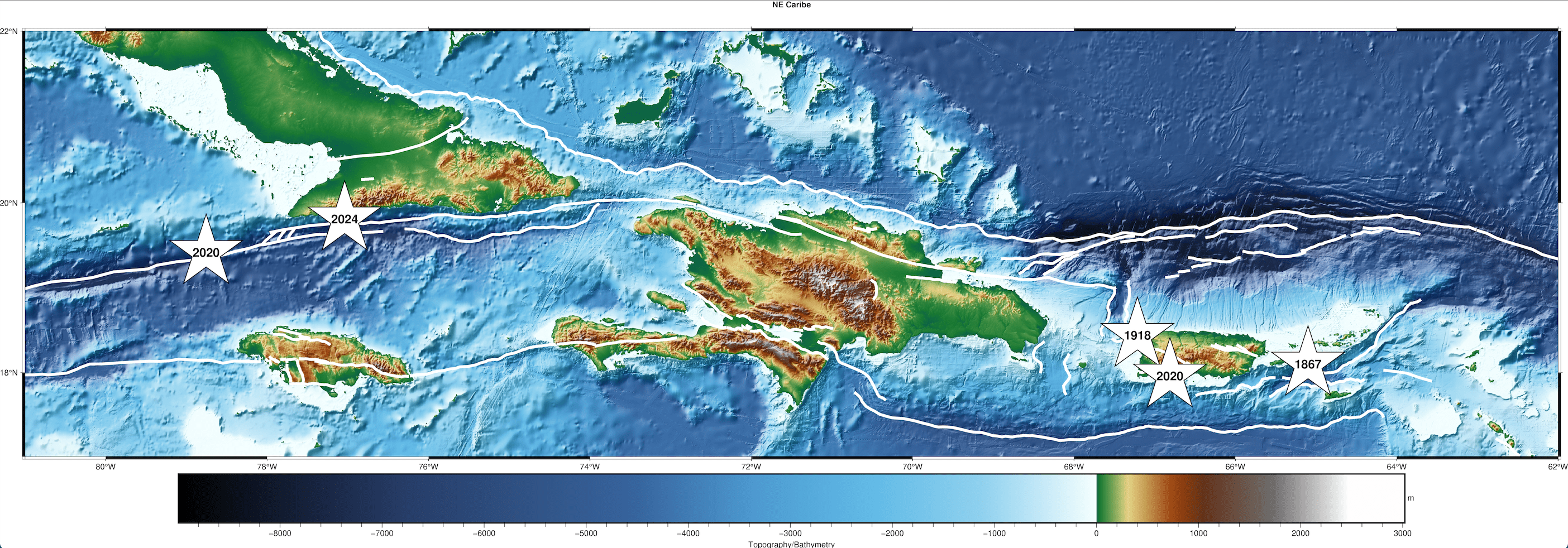
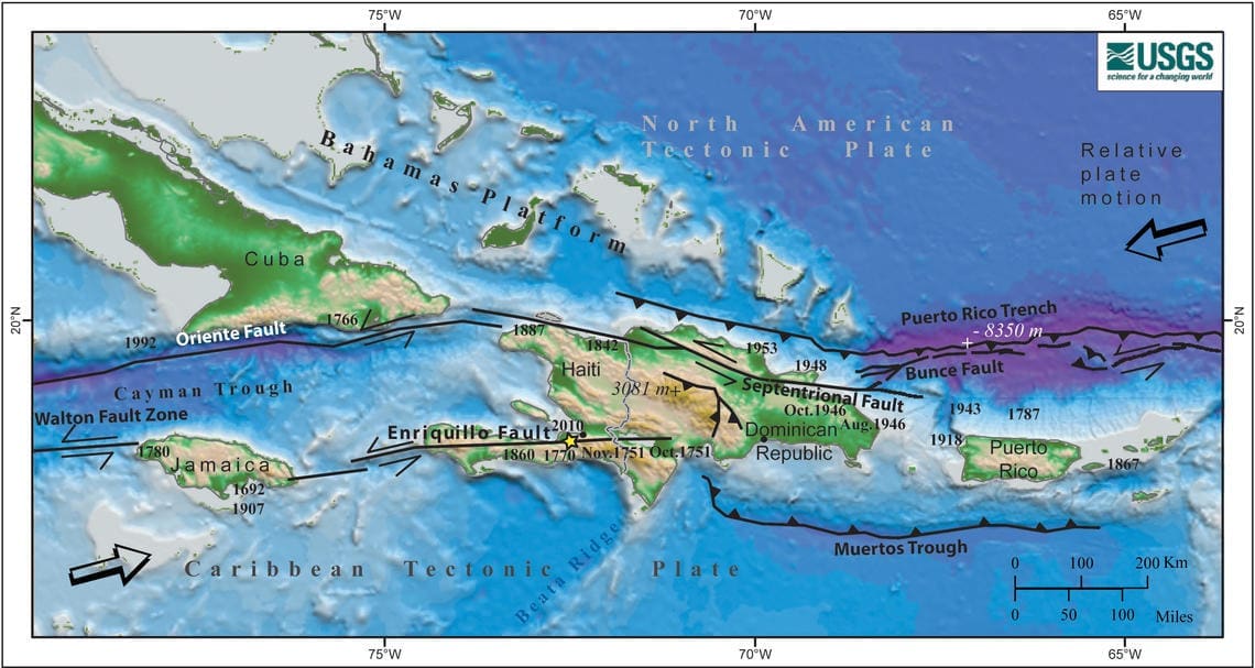
“This type of fault would be consistent with the expected tectonics of the area where the North American Plate is moving laterally relative to the Caribbean Plate. Notably, this earthquake is about 185 km east of [a] magnitude 7.7 earthquake that occurred near Jamaica in 2020, which is also associated with the plate boundary,” Vanacore stated.
“Earthquakes in this region do not signify that something similar or stronger near the USVI [or] PR,” she added.
The Magnitude and Power of a Temblor
Vanacore shared how an earthquake’s magnitude can be interpreted.
“Magnitude is a quantitative measure of the energy released during an earthquake, [and] each change in magnitude is [equivalent to a] 32 [times] change in energy,” Vanacore said. “For instance, a magnitude seven earthquake releases 32 times more energy than a magnitude six earthquake,” she explained. “To put things in perspective, a magnitude seven earthquake would release about the same energy as approximately 478,000 tons of TNT [trinitrotoluene], [which is equal to] 30 Hiroshima bombs. A magnitude six earthquake would release the energy of about 86,000 tons of TNT, [which is equal to] 6 Hiroshima bombs.”
Interestingly, the scale of earthquake magnitude does not have an upper limit, and several scales are utilized to determine the size of a quake.
“Magnitude scales can be used to describe earthquakes so small that they are expressed in negative numbers. The scale also has no upper limit,” according to information from Michigan Technological University.
Still, Vanacore noted that there is a physical limit to how powerful a quake could be.
“While theoretically there is no limit to earthquake magnitude, there is a physical limit,” Vanacore said. “Earthquake magnitude used for large earthquakes is directly related to the size of the fault. The limit on Earth is the size of the fault itself, [and] no fault large enough to generate a magnitude ten event currently is known to exist on Earth. A fault would need to extend around most of the Earth to be capable of a magnitude ten,” Vanacore stated. “The largest [seismic] event on record is a magnitude 9.5 that occurred in Chile in 1960 [and] required [a] rupture along a fault approximately 1000 miles long [to attain the high magnitude],” she added.
Vanacore also mentioned that the “Richter scale” is well-known, however more modern versions of this magnitude scale are currently utilized.
“The Richter scale is a colloquial term often used by the media to mean magnitude. This scale was originally developed in 1935 for Southern California. The modern version of this scale is referred to as ‘local magnitude’ (ML) and is empirically derived for each individual region. However, for large events like the one in Cuba, this magnitude (local) is not used; rather it is a magnitude called ‘moment magnitude,’” explained Vanacore. (More information about earthquake magnitude scales is available from the USGS here.)
“The amount of shaking experienced during an earthquake, however, depends not only on the amount of energy released but also other factors such as where you are relative to the earthquake and the type of building in which you reside,” Vanacore noted. “Shaking measured by intensity is a qualitative measure of the shaking experienced at a location during an earthquake, [and] this is why ‘Did You Feel It?’ reports are critical information for seismic networks,” she added.
Quakes “Do Not Follow a Schedule”
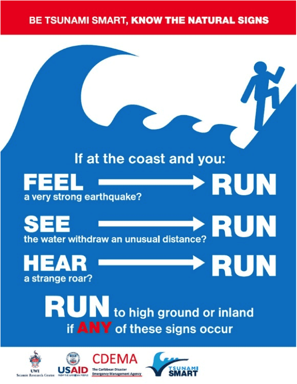
Vanacore stressed that earthquakes are unpredictable. While it has been a long time since a powerful quake affected the local islands, shaking could occur at any time, and it is essentially impossible to forecast when or where it may strike. Tsunamis generated by quakes are also a major threat to the islands.
“The most significant earthquake in recent history for the Virgin Islands is the 1867 Anegada Passage earthquake and tsunami. This stemmed from a magnitude 7.3 earthquake roughly 20 km southwest of St. Thomas,” Vanacore stated in a previous Source interview. “[The temblor] generated a tsunami with a maximum height of approximately 15 meters. However, even earthquakes from a distant location can generate tsunamis impacting the Caribbean,” Vanacore added.
“Earthquakes unfortunately do not follow a schedule,” Vanacore said. “Infamously, the Parkfield Earthquakes [a set of quakes along a section of the San Andreas Fault in California] that were thought to follow a well understood pattern was originally predicted to have another magnitude 5.5 earthquake [or higher] between 1985 and 1993 after a pattern of events in 1857, 1881, 1901, 1922, 1934, and 1966. [However,] no such earthquake occurred until 2004.”
“The reality for the USVI and Puerto Rico is that we are in an active tectonic region dominated by the subduction of the North American Plate beneath the Caribbean,” Vanacore described. “This results in complex faults throughout the region and a consistent earthquake and tsunami hazard for the region. Currently, the USGS is leading an update to the seismic hazard maps in the region (USVI and PR) that will be published in 2025. This update includes collaboration with UPRM and PRSN scientists,” she continued.
Earthquake Safety
While it may not be possible to predict exactly when or where shaking could happen, individuals can be prepared for a disaster.
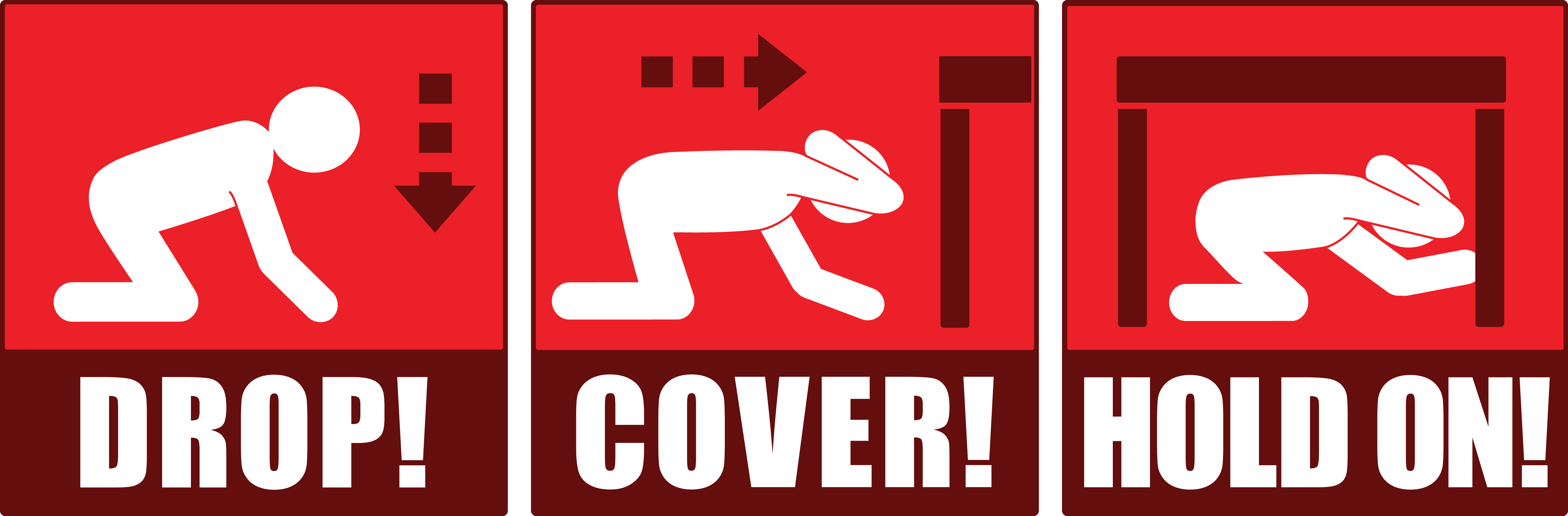
“During an earthquake, it is critical for people to ‘Drop, Cover, and Hold On’ to protect themselves,” Vanacore advised.
“If you are driving your car [during a] small [seismic] event, you might not perceive the earthquake,” she explained. “However, if there is a larger event, recommended actions become situational. For instance, if you are in a safe area without electric poles or trees, then you should come to a stop, pull the handbrake, and protect your head with your arms,” Vanacore cautioned.
“For more information on how to protect yourself before during and after an earthquake, see the PRSN educational website. [Individuals] can also check resources from the Virgin Islands Territorial Emergency Management Agency (VITEMA)” she advised.
Vanacore concluded her remarks by encouraging the public to get involved in drills and exercises that are intended to familiarize residents and visitors across the region to be ready in the event of an earthquake or a tsunami.
“Understanding the hazards due to earthquakes and tsunamis in the region is constantly improving thanks to efforts of scientists and emergency managers both in the USVI and Puerto Rico,” Vanacore declared. “Relationships across the islands are critical to our continued resilience, [and] while earthquakes and tsunamis cannot be predicted, we can all prepare for them,” she noted.
“[Preparing for quakes] includes participating in activities like [the Great] ShakeOut and Caribe Wave, as well as taking ownership of your own preparedness at home. The PRSN and VITEMA have information available to learn about earthquakes and tsunamis, and most importantly, how to prepare for them,” she recommended.
Weather information is also updated regularly on the Source Weather Page, the Source YouTube Channel, and on the official website of the National Weather Service in San Juan, Puerto Rico. USVI residents and visitors can also sign up for emergency alerts, including earthquake notifications, from VITEMA.


