HomeNewsLocal newsFlood Watch Remains in Effect as Unsettled Weather Continues Across USVI and...

Flood Watch Remains in Effect as Unsettled Weather Continues Across USVI and Puerto Rico

Visible satellite imagery obtained at 8:40 a.m. Tuesday shows a broad area of clouds and moisture across parts of the northeastern Caribbean as unsettled weather continues across Puerto Rico and the U.S. Virgin Islands. (Photo courtesy NOAA)

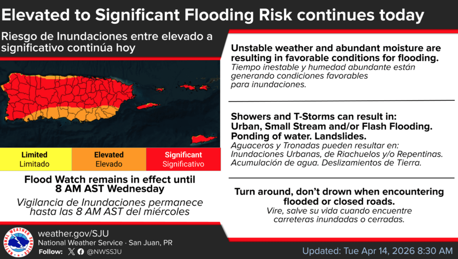
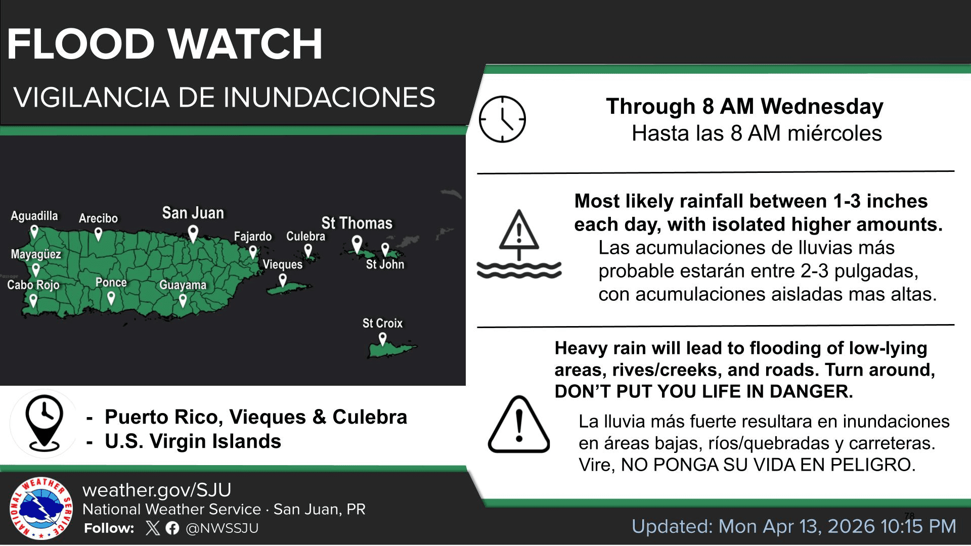
The National Weather Service in San Juan, Puerto Rico, said Tuesday that unsettled weather will continue across the U.S. Virgin Islands and Puerto Rico, where a Flood Watch is in place through Wednesday morning as showers and thunderstorms raise the risk of flooding across the region.

Flood Watch and Rainfall Threat

The NWS said additional periods of heavy rainfall will continue to raise the risk of flooding across the region, with flash flooding possible as soils become increasingly saturated. Rivers and streams may rise out of their banks, and landslides are also possible.

“The Flood Watch remains in effect through Wednesday morning, as conditions remain favorable for excessive rainfall and flooding across the region,” the NWS said. “While the exact placement and timing of the heaviest rainfall has varied from earlier expectations, the overall forecast remains on track, with a moist and unstable pattern in place. Additional rainfall amounts of one to three inches per day, with locally higher totals, are expected to continue on Tuesday.”

Although the Flood Watch is set to expire at 8 a.m. Wednesday, meteorologists cautioned that rainfall and thunderstorms will likely continue at times through the rest of the week, and gusty winds are also possible.

“Deteriorating weather conditions are expected to continue through the rest of the week as an unsettled pattern promotes periods of showers and thunderstorms across the region,” the NWS said. “Variable and unstable weather conditions will prevail across the U.S. Virgin Islands, driven by increasing atmospheric instability and shifting wind patterns, which will support the development of scattered to numerous showers and isolated thunderstorms,” the NWS continued.

Dark clouds hang over Christiansted Harbor on St. Croix on Tuesday as unsettled weather continues across the territory. (Source photo by Jesse Daley)
Dark clouds hang over Christiansted Harbor Tuesday on St. Croix as unsettled weather continues across the territory. (Source photo by Jesse Daley)

Marine Conditions

Marine and beach hazards are also expected to persist. The NWS said pulses of a northerly swell will continue to affect the region over the next several days, and that showers and thunderstorms over the local waters will create locally hazardous marine conditions through at least midweek.

The NWS also noted that “a moderate risk of rip currents is expected to continue for most north- and east-facing beaches of Puerto Rico, including Vieques and Culebra, as well as the U.S. Virgin Islands.”

Wet conditions are seen along the Christiansted Harbor boardwalk on St. Croix on Tuesday morning as periods of showers continue across the region. (Source photo by Jesse Daley)
Wet conditions are seen along the Christiansted Harbor boardwalk Tuesday morning on St. Croix as periods of showers continue across the region. (Source photo by Jesse Daley)

Local Weather Updates

Information regarding the weather across the USVI, including marine forecasts, is available from the NWS and NOAA. Additionally, the local forecast is regularly updated on the Source Weather Page, where a weekly video forecast is available. Residents and visitors can also view weather alerts and disaster preparedness information from the Virgin Islands Territorial Emergency Management Agency.

A National Weather Service graphic shows an elevated to significant flooding risk continuing Tuesday across Puerto Rico, Vieques, Culebra and the U.S. Virgin Islands, where unstable weather and abundant moisture are creating favorable conditions for flooding. (Photo courtesy NWS)
A Flood Watch remains in effect through 8 a.m. Wednesday for Puerto Rico and the U.S. Virgin Islands. (Photo courtesy NWS)
Keeping our community informed is our top priority.
If you have a news tip to share, please call or text us at 340-244-6631.

Support local + independent journalism in the U.S. Virgin Islands

Unlike many news organizations, we haven't put up a paywall – we want to keep our journalism as accessible as we can. Our independent journalism costs time, money and hard work to keep you informed, but we do it because we believe that it matters. We know that informed communities are empowered ones. If you appreciate our reporting and want to help make our future more secure, please consider donating.


Jobs - Click Here