

The National Weather Service in San Juan, Puerto Rico, warns that coastal conditions will worsen through midweek as a long-period northwesterly swell combines with strengthening winds. Marine alerts are in effect, with passing showers and slightly cooler temperatures also expected across the islands.
Hazardous Marine Conditions Expected to Intensify
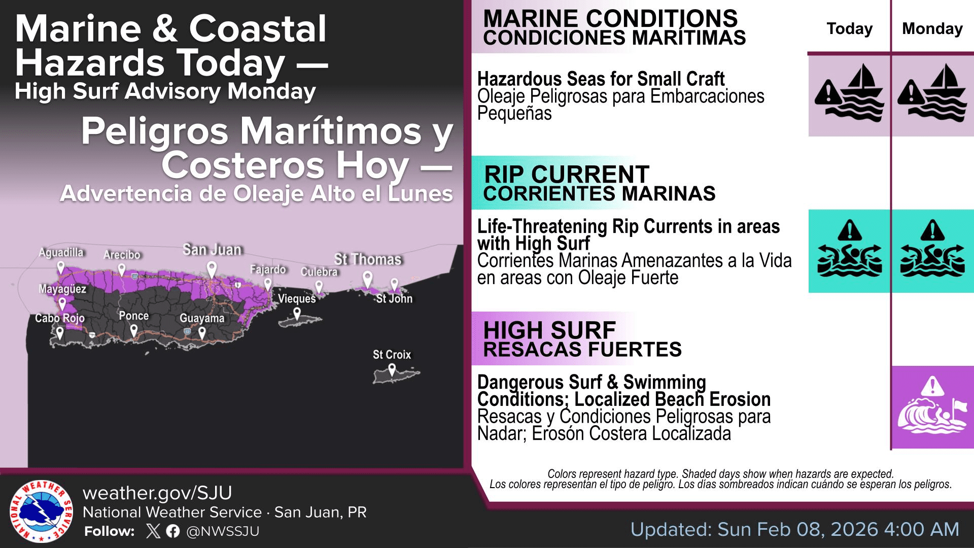
On Sunday afternoon, the NWS explained that a northwesterly swell has been affecting the local waters throughout the weekend, causing choppy seas. However, starting on Monday, a larger swell will worsen marine conditions.
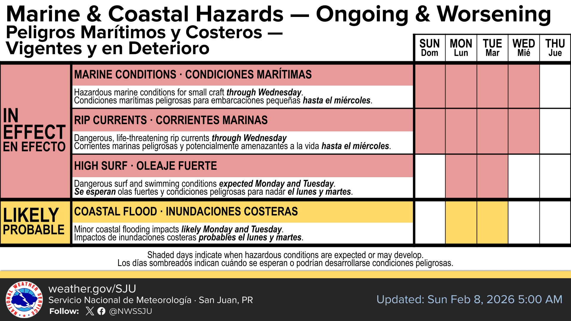
“By Monday, a large, long-period northwesterly swell is expected to deteriorate marine conditions,” the NWS reported. “Additionally, early in the week, strengthening high pressure over the southwestern Atlantic and into the central Atlantic will result in increasing northerly winds. The combination of the large swell and stronger winds will promote hazardous seas across the remainder of the local waters through at least midweek,” the NWS said.

Because of the anticipated rough seas, several marine alerts are currently active across the waters of both U.S. territories until at least Wednesday, including a Small Craft Advisory and a High Risk of Rip Currents. A High Surf Advisory will go into effect on Monday morning, and Coastal Flood Advisories could also be issued.
“High surf conditions, including localized beach erosion and dangerous swimming conditions, are likely on Monday and Tuesday as seas build between eight and 12 feet, with periods of around 13 to 15 seconds,” the NWS said. A period of a swell refers to the time between breaking waves.
“Beachgoers are urged to continue monitoring forecast updates and to follow all local advisories, warnings, and guidance from lifeguards and local officials as conditions continue to deteriorate,” the NWS stated.
Rain Chances Continue With Slightly Cooler Temperatures
While hazardous seas remain the primary concern, the NWS also explained that showers and a brief period of cooler temperatures should be expected across the region.
“Across the U.S. Virgin Islands, weather conditions on Monday will remain variable as cloudiness and moisture associated with a frontal boundary persist near the islands. Although widespread heavy rainfall is not anticipated, frequent showers may lead to ponding of water on roadways,” the NWS said.
The NWS noted that winds out of the north will lead to cooler weather through the middle of the week.
“On Monday and Tuesday, a northerly wind flow will prevail across the region, enhancing much cooler temperatures across the islands,” the NWS reported. “As a result, residents can expect slightly cooler daytime temperatures, followed by pleasant nighttime conditions, with lows reaching the lower 60s Fahrenheit across mountainous areas of Puerto Rico and even cooler in some localized locations. Across urban and coastal areas, low temperatures are expected to range from the upper 60s to the lower 70s Fahrenheit.”
The NWS added that warmer temperatures, along with an enhanced chance of rainfall associated with the passage of another frontal boundary and an associated prefrontal trough of low pressure, are forecast to occur by next weekend.
Local Weather Updates
Local weather information, including marine weather conditions, is available from the NWS, the NHC, and the National Oceanic and Atmospheric Administration. Additionally, the local weather forecast for the U.S. Virgin Islands is regularly updated on the Source Weather Page. Residents and visitors can also find weather alerts and preparedness information from the Virgin Islands Territorial Emergency Management Agency.


