
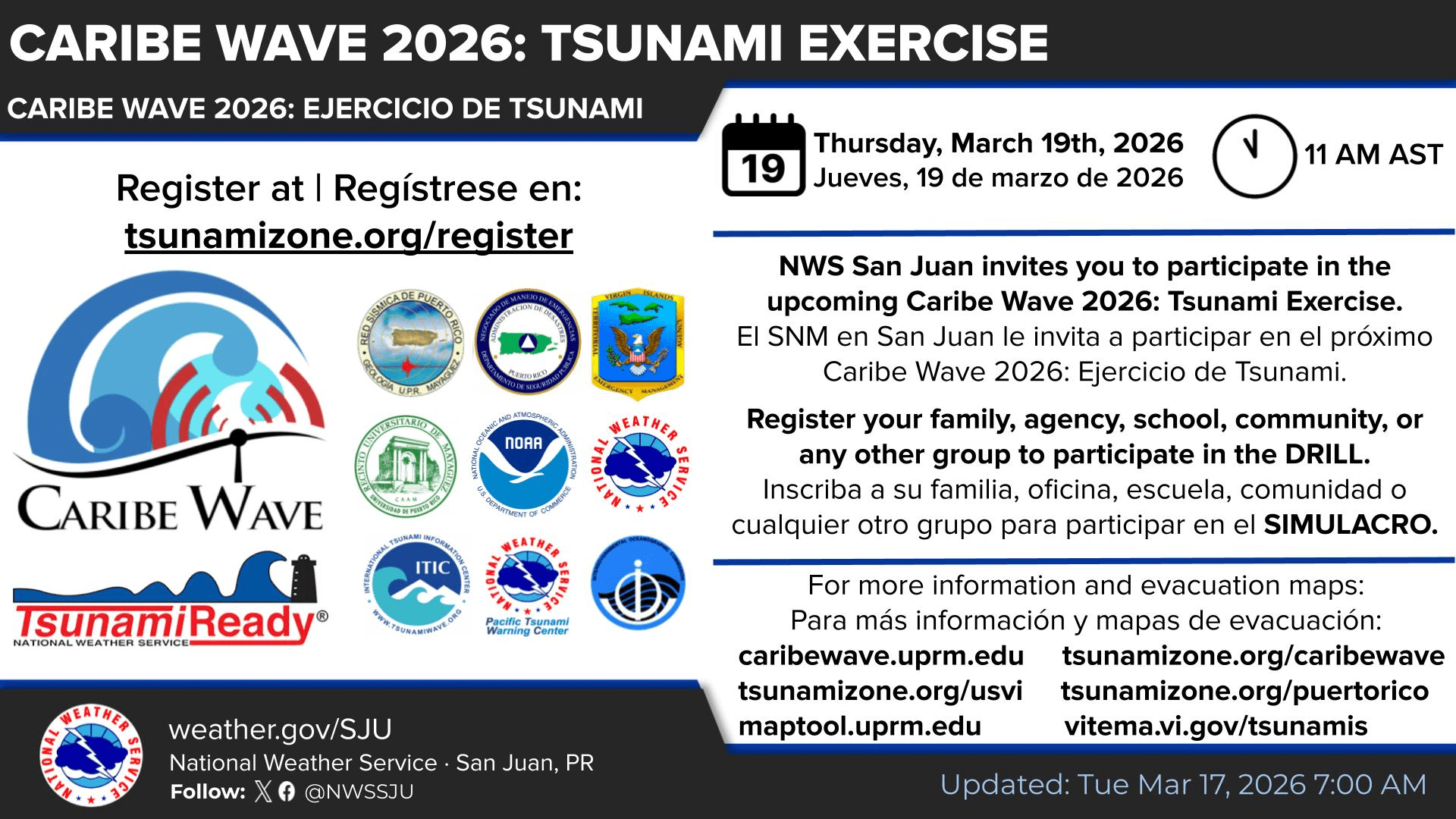
Residents, schools, businesses, and government agencies across the U.S. Virgin Islands are urged to take part in Caribe Wave 2026 on Thursday. The regional tsunami exercise is designed to test warning systems and help coastal communities practice how they would respond during a real event.
The 15th annual exercise is scheduled for 11 a.m. AST and is part of a broader Caribbean-wide effort to strengthen tsunami preparedness. Caribe Wave is coordinated through the United Nations Educational, Scientific and Cultural Organization’s Intergovernmental Oceanographic Commission’s Caribbean and Adjacent Regions Tsunami Warning System, known as ICG/CARIBE-EWS. The event is intended to help agencies and the public review warning communications, emergency procedures, and evacuation readiness.
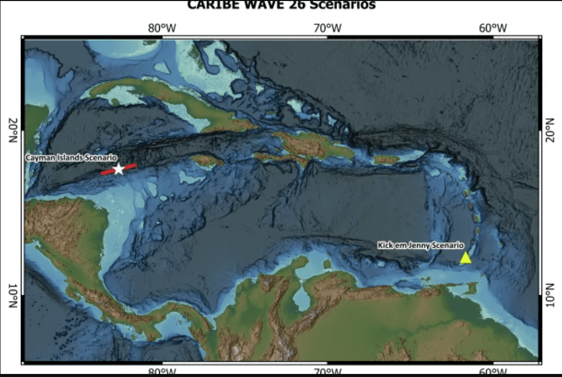
Organizers said participating areas can choose between two hypothetical scenarios for this year’s exercise: a tsunami generated by a magnitude 7.6 earthquake southwest of the Cayman Islands, or a tsunami triggered by volcanic activity involving Kick-’em-Jenny, an underwater volcano near Grenada.
Exercise Participation
The U.S. Virgin Islands and Puerto Rico will participate in the “Kick-’em-Jenny” tsunami exercise, based on a scenario in which volcanic activity near Grenada generates a tsunami that reaches the islands within approximately two to three hours.
Information provided by the Virgin Islands Territorial Emergency Management Agency explained how individuals can participate in the exercise.
“The Caribe Wave 2026 scenario will simulate a tsunami generated by a flank collapse of Kick ’em Jenny, a submarine volcano located in the southeastern Caribbean near Grenada,” VITEMA said in a recent press release. “This scenario will simulate the communication and coordination processes that would occur during an actual tsunami threat to the Caribbean region.”
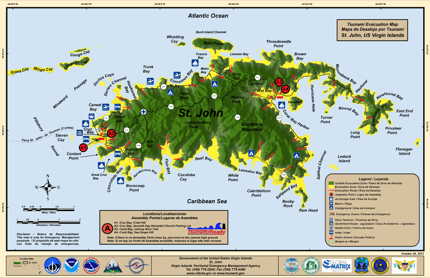
VITEMA encouraged residents, businesses, schools, and organizations to register for Caribe Wave by Wednesday. On Thursday, participants will review or practice their tsunami evacuation plans with family, co-workers, or classmates. Members will conduct a simple tsunami discussion at home or work, review or download tsunami evacuation maps from VITEMA’s website, and identify evacuation routes from their location to higher ground.
VITEMA has also said that the Emergency Alert System will be involved in the Caribe Wave event.
“As part of the exercise, VITEMA will be conducting a test of the Emergency Alert System. Residents should expect a test message to be delivered to their mobile phones on March 19th. This system-wide test is separate from the Alert VI system and does not require residents to opt- in to receive the alert. IMPORTANT: the alerts you receive on March 19th are ONLY A TEST. No action is required beyond practicing your tsunami preparedness plan,” the VITEMA press release said.
The Source spoke with Regina Browne, deputy director of Planning and Preparedness at VITEMA, who said this year’s exercise, in addition to testing the Emergency Alert System, will also help the agency review its internal readiness and continuity planning. “The exercise will help our continuity of operations plan, to practice how to handle a situation if our building is compromised, and where we would go,” Browne stated.
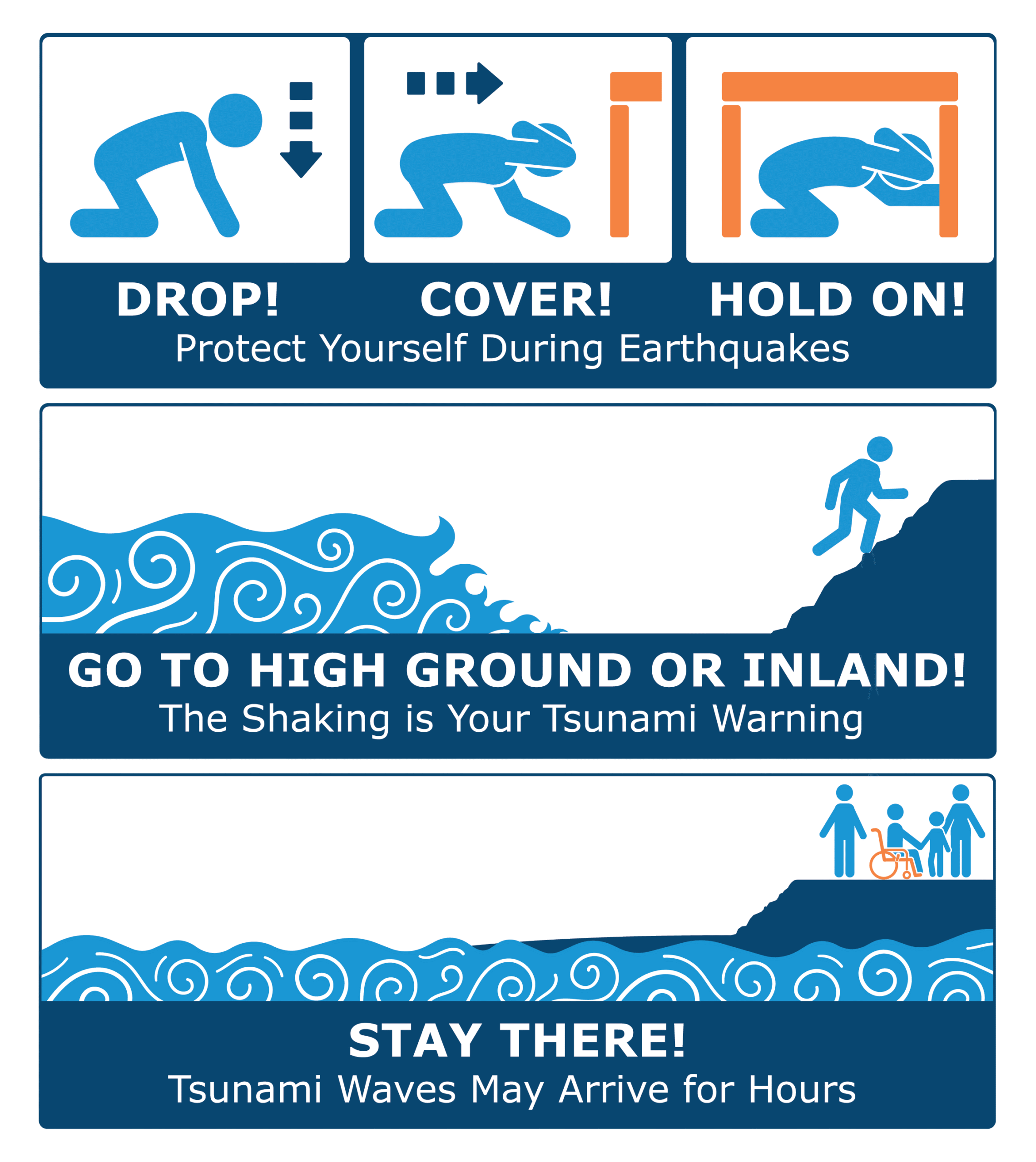
Browne also emphasized that tsunami preparedness matters year-round in the Virgin Islands, because these events can happen without warning. “Tsunamis are considered no-notice events. It’s not a season like hurricanes. So please have conversations with your family and friends, get prepared, and plan your evacuation route — 82 feet above sea level or two miles inland,” she advised.
Browne also explained that VITEMA would be conducting educational outreach across the territory, including at public and private schools.
National Weather Service Involvement
In addition to VITEMA’s participation in the event, the National Weather Service in San Juan, Puerto Rico, is also actively involved with Caribe Wave. In comments provided to the Source, the NWS emphasized that tsunami preparedness is critical throughout the year for both Puerto Rico and the U.S. Virgin Islands.
“Due to our geographic locations, both Puerto Rico and the U.S. Virgin Islands are exposed to tsunami events,” according to Maria Novoa-Garcia, a meteorologist with the NWS. “Just last year, on February 8th, 2025, a Tsunami Advisory was issued for Puerto Rico and the U.S. Virgin Islands due to an earthquake with an initial magnitude of 7.5 located north of Honduras,” she said.
“Although the advisory was canceled, the threat remained possible across the islands’ coastal areas. Therefore, reviewing and familiarizing yourself with tsunami procedures annually can be very helpful during tsunami emergencies,” according to Novoa-Garcia.
The NWS said that the agency will activate the Emergency Alert System in Puerto Rico for the event, and the message will be broadcast across NOAA weather radios.
“The NWS in San Juan will use this opportunity to test our tsunami emergency procedures, including the activation of the Emergency Alert System for Puerto Rico and the U.S. Virgin Islands,” Novoa-Garcia continued. “The exercise will allow the NWS to make any updates to the system if required and ensure the Emergency Alert System will work in a real situation.”
Tsunamis and Seismic Activity Across the Region
While Caribe Wave is only an exercise, the hazards it is based on are very real. The USVI and Puerto Rico lie in an active seismic zone, and the Source has previously reported on earthquake and tsunami preparedness in the region. Residents and visitors can read about earthquakes across the region in the Source’s prior coverage.
The exercise gives public agencies an opportunity to evaluate how alerts are shared and how emergency procedures function under simulated conditions. Organizers say the annual drill is meant not only for emergency managers and forecasters, but also for residents, workplaces, and schools that may need to make quick decisions during a real tsunami threat.
According to the National Centers for Environmental Information, in the past 500 years, over 65 confirmed tsunamis have been observed, and approximately 4,500 people have lost their lives to tsunamis in the Caribbean and adjacent regions. Population growth and influx of tourists along the Caribbean and Western Atlantic coasts increase the tsunami vulnerability of the region.
“The Caribe Wave exercise helps people understand what a real event looks like and what actions to take when encountering that situation,” Novoa-Garcia noted. “It’s a good time for citizens to review their emergency plan with family members, check if their residence is in a tsunami hazard zone, and familiarize themselves with the procedures,” Novoa-Garcia concluded.
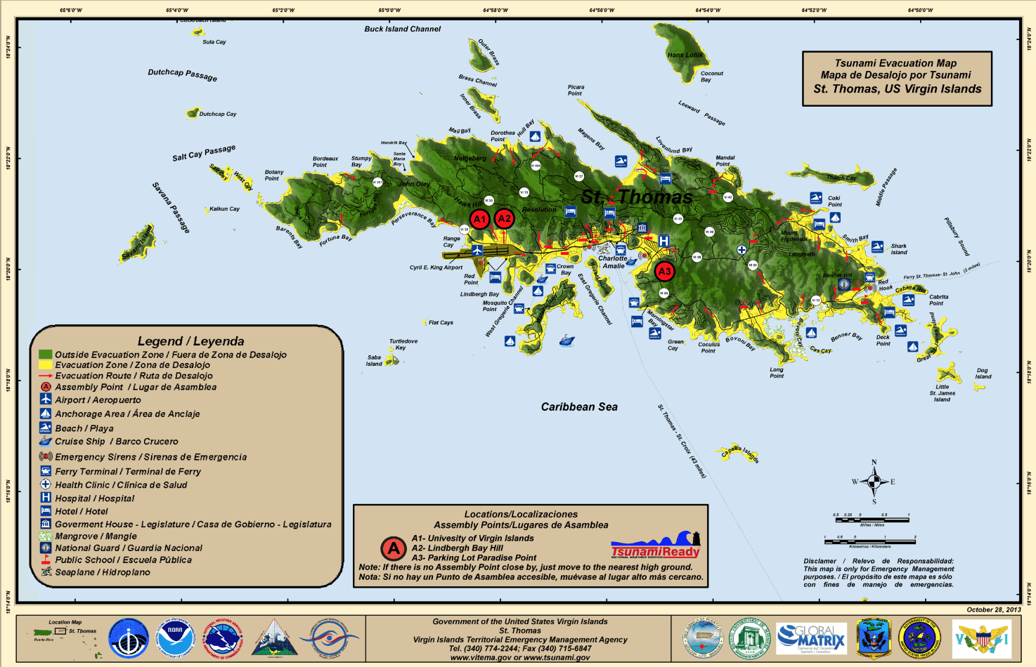
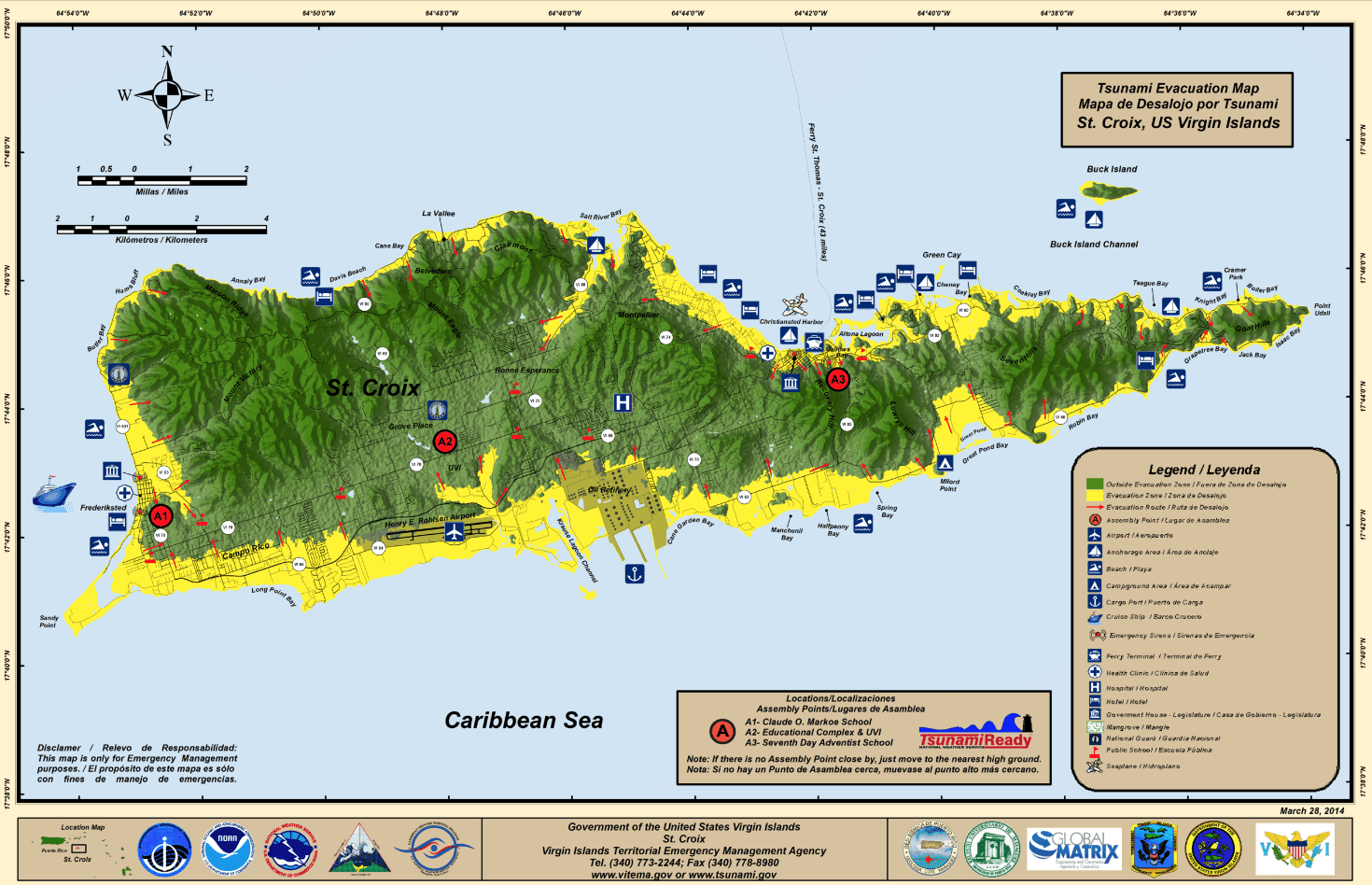
In the U.S. Virgin Islands, tsunami preparedness information is available through the official TsunamiZone website, as well as VITEMA’s website, which provides tsunami evacuation maps for St. Thomas, St. John, and St. Croix.
Stay Informed
Local weather forecast information, marine weather updates, and severe weather alerts are posted regularly on the Source Weather Page and on the official website of the NWS. USVI residents and visitors can also sign up for emergency alerts, including earthquake and tsunami notifications from VITEMA.


