
A massive 8.8 magnitude earthquake off the coast of Russia on July 29 triggered tsunami alerts across the Pacific Ocean, serving as a reminder that coastal regions must stay prepared. While the U.S. Virgin Islands were not impacted, seismic activity is common in the Caribbean, and the risk remains.
The U.S. Virgin Islands and Puerto Rico lie within an active seismic zone, making it crucial for residents to understand the risk of a major earthquake or tsunami. Knowing where to go, how to interpret warnings, and what to do in an emergency are vital across the local islands. The sections below detail evacuation zones, siren testing protocols, alert systems, and essential resources for staying safe and informed.
Earthquakes and Tsunamis in the Caribbean
The National Weather Service defines tsunami waves as “a series of waves that can cause dangerous fluctuations of water along shorelines and are generated by earthquakes, volcanic eruptions, or landslides that cause a large-scale and rapid displacement of the water.”

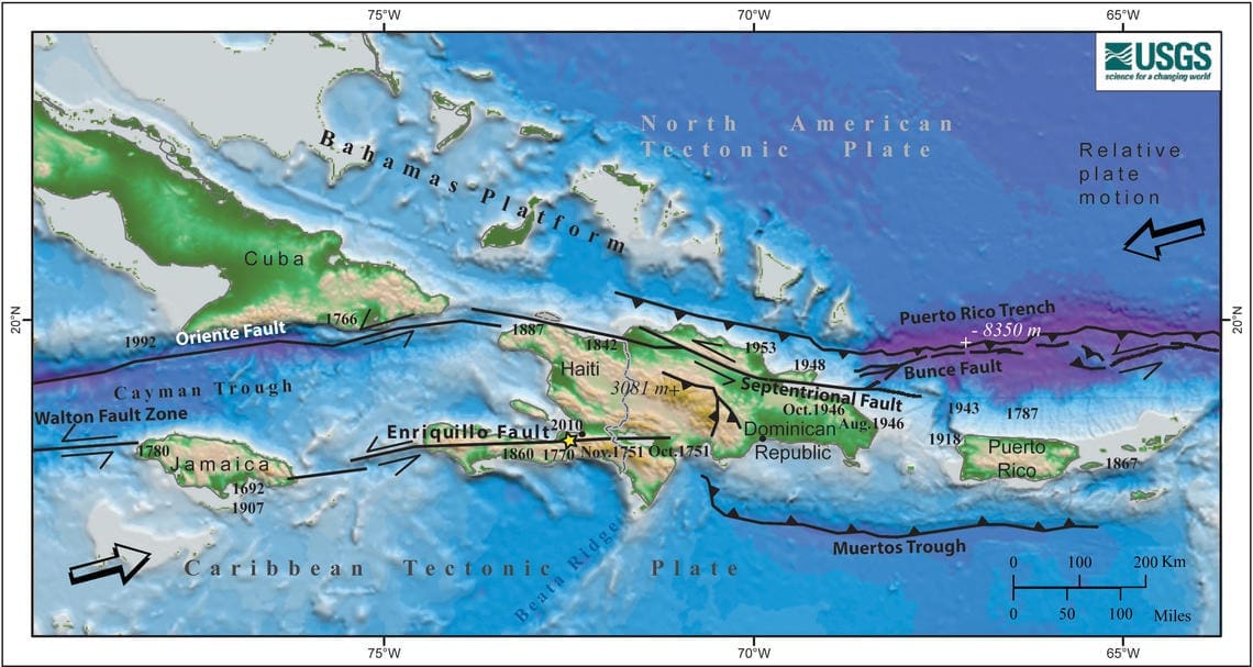
Caribbean islands are situated where temblors frequently strike due to their location among tectonic plates and fault systems.
“The tectonic plates divide the Earth’s crust into distinct ‘plates’ that are always slowly moving. Earthquakes are concentrated along these plate boundaries,” according to the United States Geological Survey.
“Puerto Rico and the Virgin Islands are located at an active plate boundary between the North American plate and the northeast corner of the Caribbean plate. Plate movements have caused large magnitude earthquakes and devastating tsunamis,” according to the USGS website.
Indeed, as recently as February, tsunami alerts were issued across parts of the Caribbean—including a tsunami advisory for the U.S. Virgin Islands and Puerto Rico—after a magnitude 7.6 earthquake struck near the coast of Honduras. Although the advisory was later canceled, it was issued quickly, underscoring how little time there may be to respond once alerts are activated.
The Source previously reported about Caribbean earthquake and tsunami activity in several interviews with Elizabeth Vanacore, Ph.D., a seismologist and a researcher at the Puerto Rico Seismic Network. The PRSN, also known by its Spanish name, Red Sísmica de Puerto Rico, is part of the University of Puerto Rico Mayagüez Department of Geology.
Based in Mayagüez on Puerto Rico’s west coast, the PRSN monitors seismic activity across Puerto Rico and the Virgin Islands to help keep residents informed and safe.
The Source recently reconnected with Vanacore following the powerful earthquake and tsunami across the Pacific to gather updated guidance on how individuals in the U.S. Virgin Islands can prepare for a tsunami event.
Brief History of USVI and PR Quakes and Tsunamis
Vanacore provided a brief history of two of the most recent major temblors and tsunamis that significantly impacted the local area.
“In Puerto Rico, the last significant tsunami causing significant damage occurred in 1918, due to a 7.2 magnitude earthquake in the Mona Canyon northwest of Aguadilla, Puerto Rico,” Vanacore said. “The 1918 tsunami is recorded to have had wave heights of up to a little over 6 meters, roughly 20 feet. The 1918 earthquake and tsunami in Puerto Rico is considered to have caused approximately 118 deaths,” Vanacore explained.
“The last tsunami causing significant damage to the Virgin Islands occurred in 1867 due to an approximate 7.2-7.5 magnitude earthquake in the Anegada Passage,” Vanacore recalled. “Tsunami wave heights from this event were up to approximately 15 meters, roughly 50 feet, across the island of Saba and some parts of St Croix,” she noted.
“In Christiansted, wave heights were approximately seven to nine meters, about 20 to 30 feet. In St Thomas, wave heights were on the order of five to seven meters, approximately 15 to 20 feet, which inundated the coastal areas,” Vanacore said. “Official deaths linked to the 1897 earthquake and tsunami are listed as 24 in the NOAA NCEI historical tsunami catalog. However, there are additional deaths linked to factors such as disease during the aftermath of the earthquake and tsunami.”
Vanacore pointed out that in each instance, there was very little time to get to a safe area before waves started rolling inland.
“In both cases, the first tsunami waves for PR and the VI began to arrive within as little as five minutes of the earthquakes,” she stated.
Evacuation Zones and Maps
Tsunami evacuation zones are established across the U.S. Virgin Islands to guide residents and visitors to safer ground in the event of a tsunami warning. These zones are typically based on elevation, proximity to the shoreline, and modeled tsunami inundation areas.
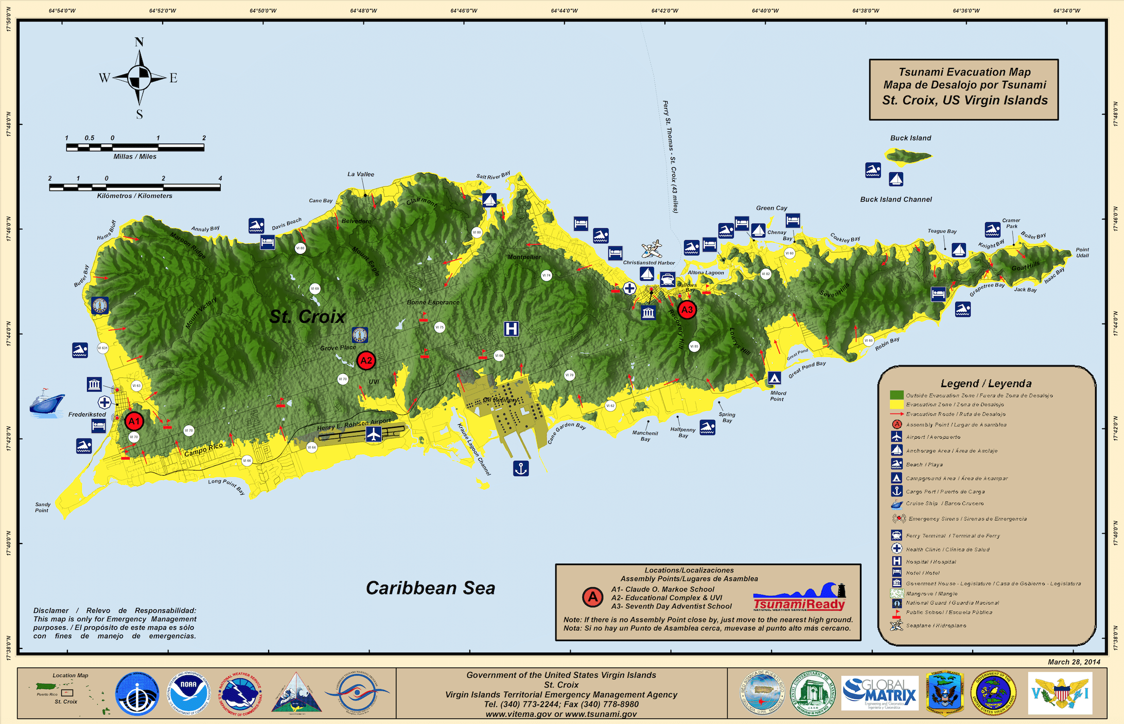
According to information available on the Virgin Islands Territorial Emergency Management Agency’s official website, areas located within a quarter mile of the coast and below 82 feet in elevation are considered at higher risk during a tsunami. Individuals in these zones may be instructed to evacuate uphill or inland following a strong earthquake or official tsunami alert.
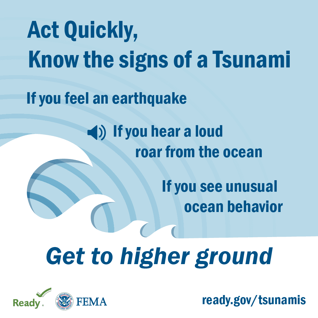
In addition to physical elevation, tsunami evacuation guidance emphasizes the importance of time. Coastal areas in the territory may only have minutes to respond after a nearby quake. As a general rule, those near the water who feel strong shaking or see the ocean recede rapidly should head inland or to higher ground immediately, even before receiving an official alert.
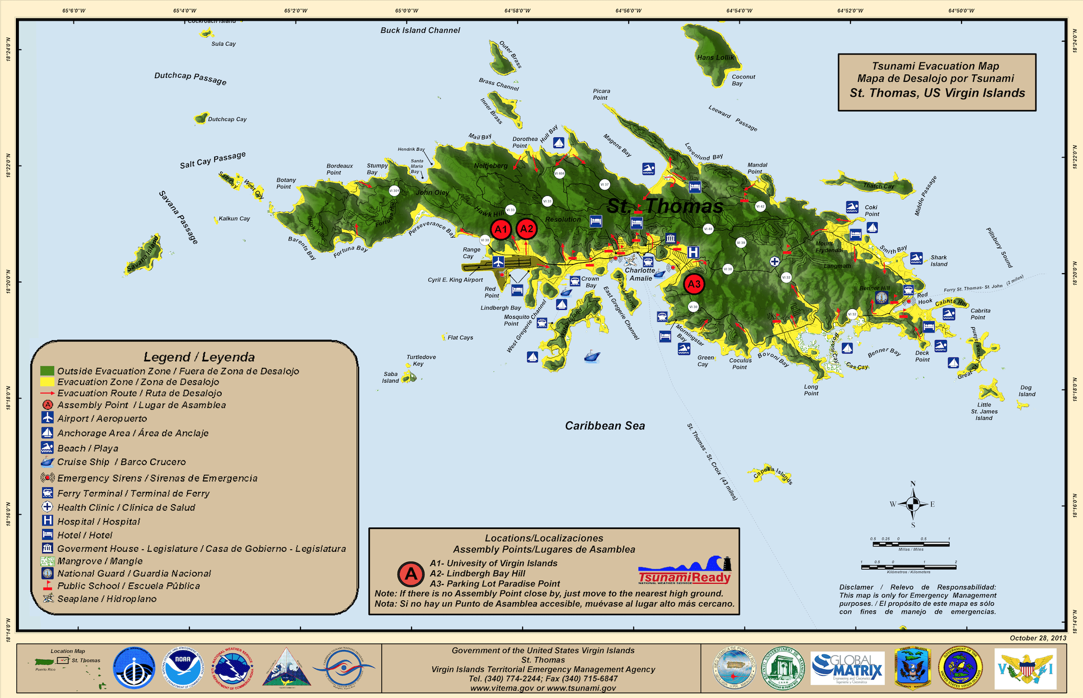
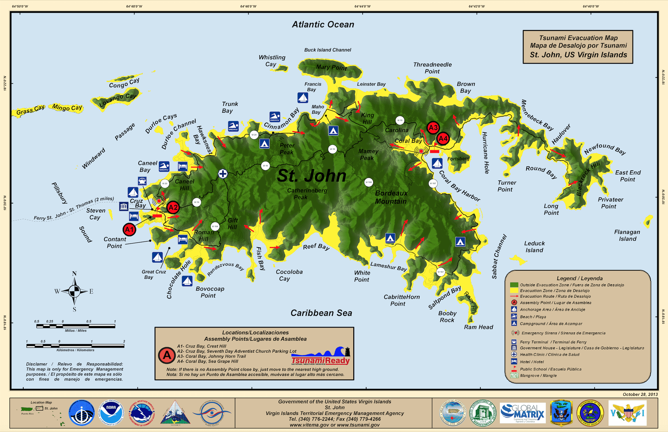
VITEMA provides printable and interactive evacuation maps for St. Thomas, St. Croix, and St. John. These maps mark evacuation zones and show safe routes to higher ground. Virgin Islands tsunami evacuation maps are available on the VITEMA website under the “Preparedness” section and are also distributed during public outreach events and yearly tsunami drills, including the annual “Caribe Wave” exercise. Additionally, evacuation maps for Puerto Rico are available on the PRSN website.
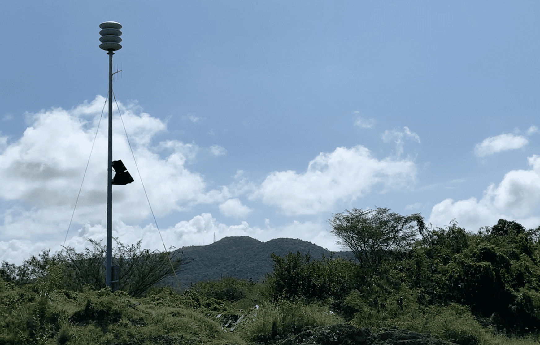
VITEMA also tests its territory-wide alert system on the third Thursday of each month, activating sirens which would be utilized in the event of an actual emergency. In addition to sirens, VITEMA uses the Alert VI system to send emergency notifications via text, phone call, and email. Residents are encouraged to register for these alerts, and USVI residents and visitors can sign up for emergency alerts, including earthquake and tsunami notifications, on the agency’s website.
Tsunami Notifications and Their Meanings
In the event of an actual emergency during which tsunami notifications are issued, the National Weather Service offers the following information about tsunami alerts and how to interpret them:
“Tsunami Warning: Take Action—Danger! A tsunami that may cause widespread flooding is expected or occurring. Dangerous coastal flooding and powerful currents are possible and may continue for hours or days after initial arrival. Follow instructions from local officials. Evacuation is recommended. Move to high ground or inland (away from the water).
Tsunami Advisory: Take Action—A tsunami with potential for strong currents or waves dangerous to those in or very near the water is expected or occurring. There may be flooding of beach and harbor areas. Stay out of the water and away from beaches and waterways. Follow instructions from local officials.
Tsunami Watch: Be Prepared—A distant earthquake has occurred. A tsunami is possible. Stay tuned for more information. Be prepared to take action if necessary.
Tsunami Information Statement: Relax—An earthquake has occurred, but there is no threat, or it was very far away, and the threat has not been determined. In most cases, there is no threat of a destructive tsunami.”
Final Thoughts
Vanacore at PRSN shared additional thoughts regarding being prepared for temblors and tsunamis, and she shared the following tips:
“If an earthquake is long or strong, that natural signal may be the first warning you receive to take action. But what can you do today?
- Know if you live, work, or play in a tsunami evacuation zone. Evacuation maps for Puerto Rico are available on the PRSN website, and maps for the VI are available on the VITEMA website.
- Have a family plan and an emergency backpack. Both PRSN and VITEMA have resources available to help you come up with a plan.
- Have a way to receive official information (e.g., a NOAA radio). It is possible that after evaluation of an earthquake and/or tsunami, tsunami alert levels can change.
- Know what actions are needed for each tsunami alert level: watch, advisory, warning.
- Participate in the ‘Great ShakeOut’ exercise in October and the ‘Caribe Wave’ event in March to practice your plan.
- Remember that while we cannot predict an earthquake and tsunami, we can prepare for them. The power rests in your hands.”
Local Weather Information
While tsunamis are relatively rare, the threat is real—and rapid. Continued public education, regular drills, and accessible evacuation tools are essential in protecting lives across the U.S. Virgin Islands. Staying informed, knowing where to go, and responding quickly can make all the difference when seconds matter.
Weather information is updated regularly on the Source Weather Page, the Source YouTube Channel, and on the official website of the National Weather Service in San Juan, Puerto Rico. USVI residents and visitors can also sign up for emergency alerts, including earthquake notifications, from VITEMA.


