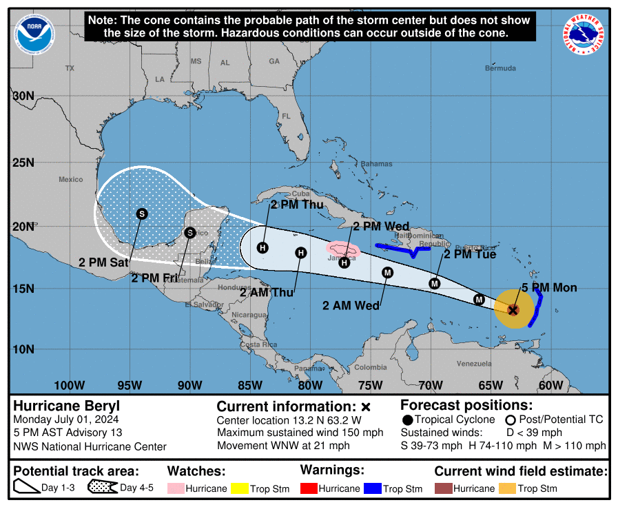
Updated: July 1 | 5 p.m. NHC Advisory
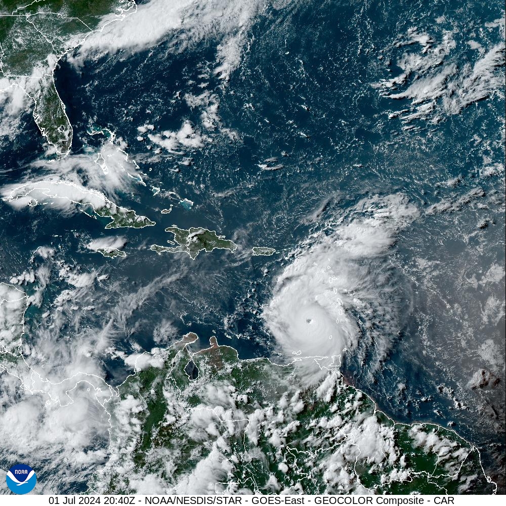
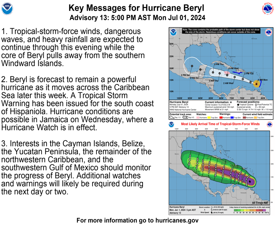
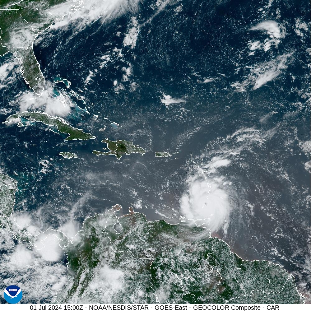
A 5:00 p.m. update from the National Hurricane Center on Monday noted that Hurricane Beryl passed across the southern Lesser Antilles on Monday as a ferocious, high-end Category 4 cyclone. The storm remains a major Category 4 hurricane and is moving west-northwest at approximately 21 mph, with maximum sustained winds of about 150 mph.
Beryl made landfall over Grenada’s Carriacou Island, and widespread damage has been reported across the region. The powerful cyclone, which has already broken historical weather records, is forecast to continue on a west-to-west-northwesterly track across the Caribbean and will move approximately 200 miles south of the U.S. Virgin Islands and Puerto Rico.
“The center of Beryl will continue moving away from the southern Windward Islands tonight and move quickly westward to west-northwestward during the next few days,” according to the NHC. “On the forecast track, the center of Beryl will move across the southeastern and central Caribbean Sea tonight through Tuesday and is forecast to pass near Jamaica on Wednesday,” the NHC continued.
Impacts Across USVI, Puerto Rico
As of 5 p.m. on Monday, no hurricane or tropical storm watches or warnings are in effect for either U.S. territory. However, the local islands will experience several impacts from Beryl, including possible rainfall, gusty winds, and hazardous marine conditions starting Monday night as Beryl continues traveling across the Caribbean.
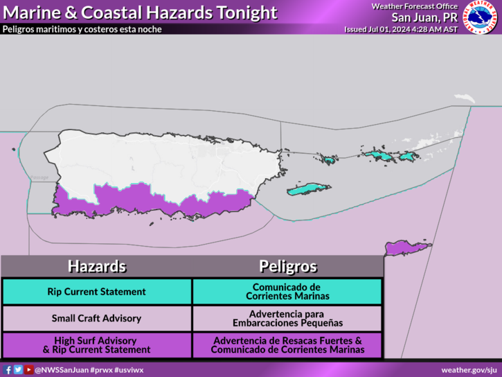
Marine weather alerts have been issued for portions of the USVI and Puerto Rico, including a High Rip Current Risk, a High Surf Advisory, a Small Craft Advisory, and a Coastal Flood Advisory.
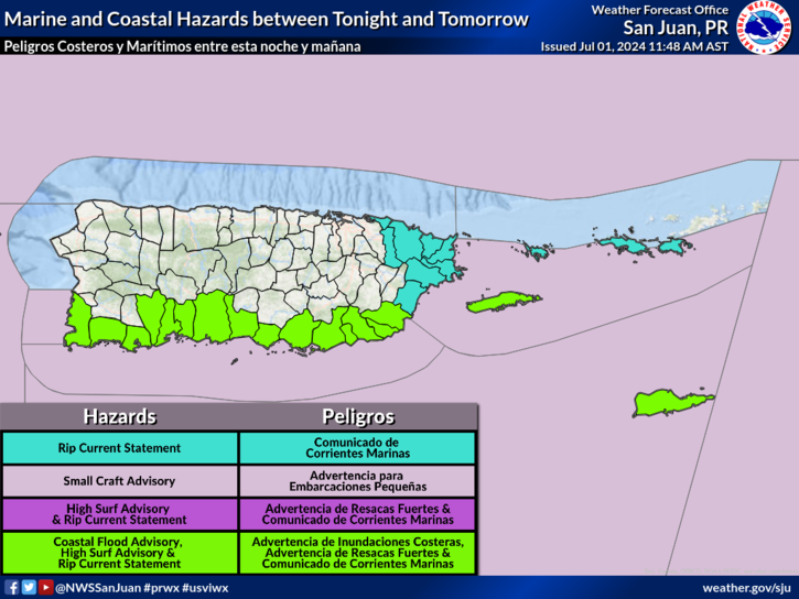
Regarding the potential impacts on the USVI and Puerto Rico, the National Weather Service in San Juan, Puerto Rico, provided the following information on Monday afternoon:
“Beryl should pass about 200 miles or more south of the islands by Tuesday morning,” the NWS said. “In its path, the outer bands of Beryl will bring periods of thunderstorms and breezy to windy conditions, with winds ranging between 25-30 mph with stronger gusts. Quick-moving showers with periods of heavy rainfall could lead to urban and small-stream flooding and localized flash flooding,” the NWS warned.
“Due to the fast-moving nature of these showers, rainfall accumulations should generally range between one and two inches with isolated higher amounts, mainly across the USVI and the eastern and southern half of Puerto Rico,” the NWS stated.
“Beryl will also bring hazardous seas and life-threatening rip currents with high surf conditions across all the islands,” the NWS added.
The NWS said that swells generated by Beryl may cause wave heights of up to 15 feet, particularly along the southern coastlines of Puerto Rico and across St. Croix in the U.S. Virgin Islands.
NHC Monitoring Additional Tropical Waves
The NHC continues to monitor a second tropical wave behind Beryl, “Invest 96L.” The wave is moving across the Atlantic and will be closely watched for potential impacts on the local islands later this week.
Following “Invest 96L,” another disturbance may bring inclement weather to the region early next week.
Finally, in addition to the busy tropical activity across the Atlantic, a cyclone formed in the Gulf of Mexico on Sunday.
“Tropical Storm Chris formed late Sunday night in the southwestern Gulf of Mexico and made landfall less than two hours later in eastern Mexico,” according to an article from Fox Weather. “Chris then weakened to a tropical depression Monday morning before dissipating a few hours later as it moved farther inland,” the article continued.
Severe Weather Updates
USVI residents and visitors are encouraged to closely monitor Hurricane Beryl and additional tropical disturbances. Weather forecast information, including severe weather alerts, is available from the VITEMA website and the National Weather Service. The Source Weather Page also publishes a daily weather forecast and offers readers the opportunity to view weather forecast videos and disaster preparedness video segments.
Information regarding hurricane preparedness from the Virgin Islands Territorial Emergency Management Agency and the National Oceanic and Atmospheric Administration.
Updated: July 1 | 11 a.m. NHC Advisory
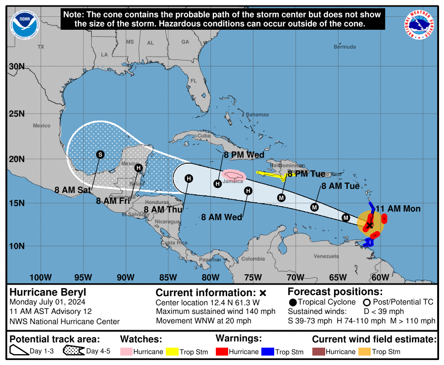
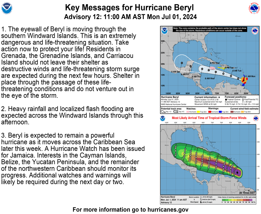
An 11 a.m. update from the National Hurricane Center on Monday explained that Hurricane Beryl has continued to intensify and is a major Category 4 storm. Beryl is moving west-northwest at approximately 20 mph, with maximum sustained winds of about 140 mph. As of the 11 a.m. update, the powerful cyclone is passing over the southern Lesser Antilles. Some additional strengthening is possible in the short term.
The NHC issued the following notice for individuals in the southern Windward Islands, highlighting the severity of this storm:
“The eyewall of Beryl is moving through the southern Windward Islands. This is an extremely dangerous and life-threatening situation. Take action now to protect your life! Residents in Grenada, the Grenadine Islands, and Carriacou Island should not leave their shelter as destructive winds and life-threatening storm surge are expected during the next few hours. Shelter in place through the passage of these life-threatening conditions and do not venture out in the eye of the storm.”
After moving across the Windward Islands, Beryl is forecast to continue on a west to west-northwesterly track across the Caribbean.
Impacts Across USVI, Puerto Rico
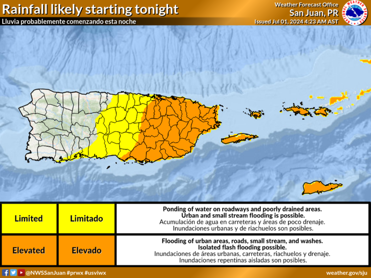
The NHC noted that Hurricane Beryl is still forecast to pass a couple of hundred miles south of the U.S. Virgin Islands and Puerto Rico. As of 11 a.m. on Monday, no hurricane or tropical storm watches or warnings are in effect for either U.S. territory.
However, the local islands will experience some impacts from Beryl, including hazardous marine conditions starting on Monday as Beryl continues to travel across the Caribbean. Several marine weather alerts have been issued for portions of the USVI and Puerto Rico. A High Rip Current Risk is currently in effect, and a High Surf Advisory and a Small Craft Advisory will be in effect later Monday.
Regarding the potential storm impacts on the USVI and Puerto Rico, the National Weather Service in San Juan, Puerto Rico, provided the following information on Monday morning:
“Beryl should pass about 200 miles or more south of the islands through Tuesday morning,” the NWS said. “In its path, the outer bands of Beryl will bring periods of thunderstorms and breezy to windy conditions, with winds ranging between 25-30 mph with stronger gusts. Quick-moving showers with periods of heavy rainfall could lead to urban and small-stream flooding and localized flash flooding,” the NWS warned.
“Due to the fast-moving nature of these showers, rainfall accumulations should generally range between one and two inches with isolated higher amounts, mainly across the USVI and the eastern and southern half of Puerto Rico,” the NWS stated.
“Beryl will also bring hazardous seas and life-threatening rip currents with high surf conditions across all the islands,” the NWS added.
NHC Monitoring Additional Tropical Waves
In addition to Hurricane Beryl, the NHC continues to monitor a second tropical wave behind Beryl, “Invest 96L.” The tropical wave is moving across the Atlantic and will be closely watched for potential impacts on the local islands later this week.
Following “Invest 96L,” another disturbance may bring inclement weather to the region early next week.
Severe Weather Updates
The weather forecast and cyclone track can change quickly. USVI residents and visitors are encouraged to closely follow Hurricane Beryl and additional tropical disturbances.
Information regarding hurricane preparedness from the Virgin Islands Territorial Emergency Management Agency and the National Oceanic and Atmospheric Administration.
Weather forecast information, including severe weather alerts, is available from the VITEMA website and the National Weather Service. The Source Weather Page also publishes a daily weather forecast and offers readers the opportunity to view weather forecast videos and disaster preparedness video segments.


