Updated 7/3/24 at 6:25 p.m. AST
Weather updates are posted by Jesse Daley, who has been reporting on weather for the Source since 2022 and holds an Undergraduate Certificate in Weather Forecasting from Pennsylvania State University.
VI SOURCE WEATHER UPDATES
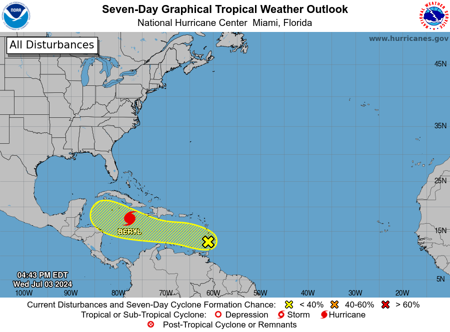
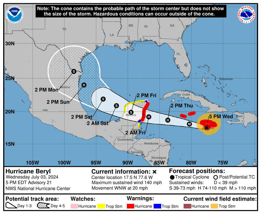
! The National Hurricane Center has explained that Hurricane Beryl continues to move across the Caribbean as a major hurricane. Another tropical wave, dubbed “Invest 96L,” is forecast to move across the region on Thursday. Please read more here.
Article Series: “Extreme Weather in the Caribbean”
- Part 1: Caribbean Earthquakes and Tsunamis
- Part 2: Caribbean Volcanoes
- Part 3: Rip Currents
- Part 4: Hurricanes
- Part 5: Wildfires
- Part 6: Flash Floods
- An article about earthquakes in the Caribbean is available here!
- An informational video about drought conditions in the USVI is available here!
- Article: Colorado State University Predicts Extremely Active 2024 Atlantic Hurricane Season
- Article: La Niña Weather Pattern May Spawn an Active 2024 Atlantic Hurricane Season
THURSDAY’S WEATHER FORECAST: 7/4/24
Happy Thursday, and Happy Fourth of July!
According to the National Weather Service (NWS) in San Juan, Puerto Rico, Thursday will be mostly cloudy with showers and thunderstorms as a tropical wave, “Invest 96L,” passes across the region. Rainfall may be heavy at times. The high temperature will be approximately 91°F, 32.7°C, with winds out of the east at about 21 to 24 mph, gusting up to 30 mph. The Heat Index is expected to be high, and staying hydrated and cool is essential. Excessive heat advisories may be issued. The chance of rain on Thursday is roughly 70 percent.
Thursday night will be mostly cloudy, with scattered showers and thunderstorms. The low temperature will be approximately 80°F, 26.6°C, with winds out of the east-southeast at about 16 to 18 mph, gusting up to 24 mph. The possibility of rain on Thursday night is roughly 80 percent.
As mentioned above, a tropical wave, “Invest 96L,” is forecast to approach the region on Thursday, bringing inclement weather to the islands. Please read more here.
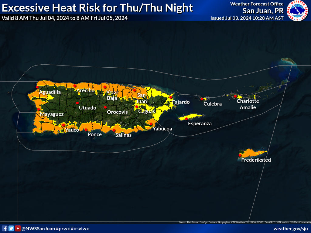
Yellow = Limited Risk, Orange = Moderate Risk, Red = Significant Risk
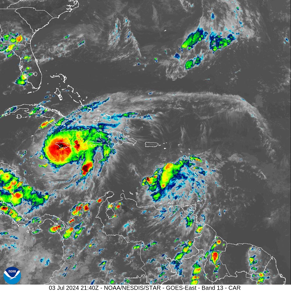
Below: Infrared satellite imagery obtained at 5:40 p.m. AST on Wednesday indicates a partly cloudy sky around the USVI and Puerto Rico. Hurricane Beryl remains a dangerous, major hurricane moving toward the west-northwest and will impact areas including Jamaica and the Cayman Islands.
MARINE WEATHER UPDATE
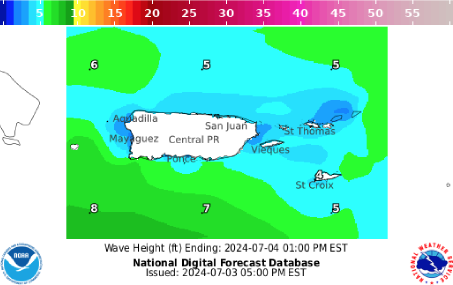
On Thursday, the seas will be approximately 3 to 5 feet, with occasional seas up to 6 feet. Winds will be out of the east at about 15 to 20 knots, gusting up to 30 knots.
On Thursday night, the seas will be approximately 2 to 4 feet, with occasional seas up to 5 feet. Winds will be out of the east-southeast at about 10 to 15 knots, gusting up to 25 knots.
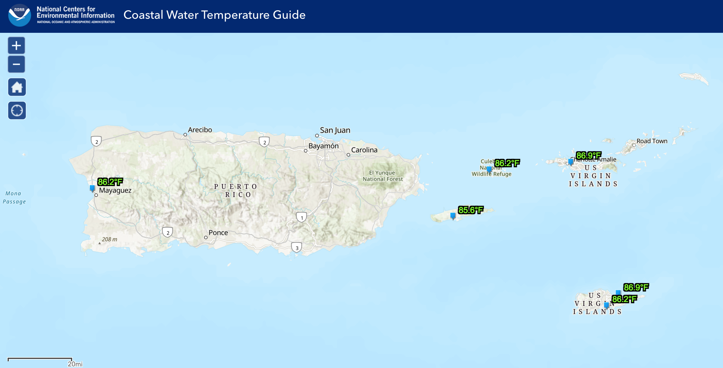
The water temperature is approximately 86°F, approximately 30°C.
Ocean Water Temperature Map from 7/2/24, courtesy of NOAA:
Wave Height Forecast Map courtesy of NWS:
HAZARDOUS CONDITIONS
Marine weather alerts will continue to be hazardous as Hurricane Beryl moves away from the region and as another tropical wave, “Invest 96L,” moves past the region. A Small Craft Advisory will continue to be in effect for portions of the waters surrounding Puerto Rico and the USVI until at least 6 p.m. on Thursday.
Rip Currents: The risk of rip currents is projected to be moderate across most of the region on Thursday.
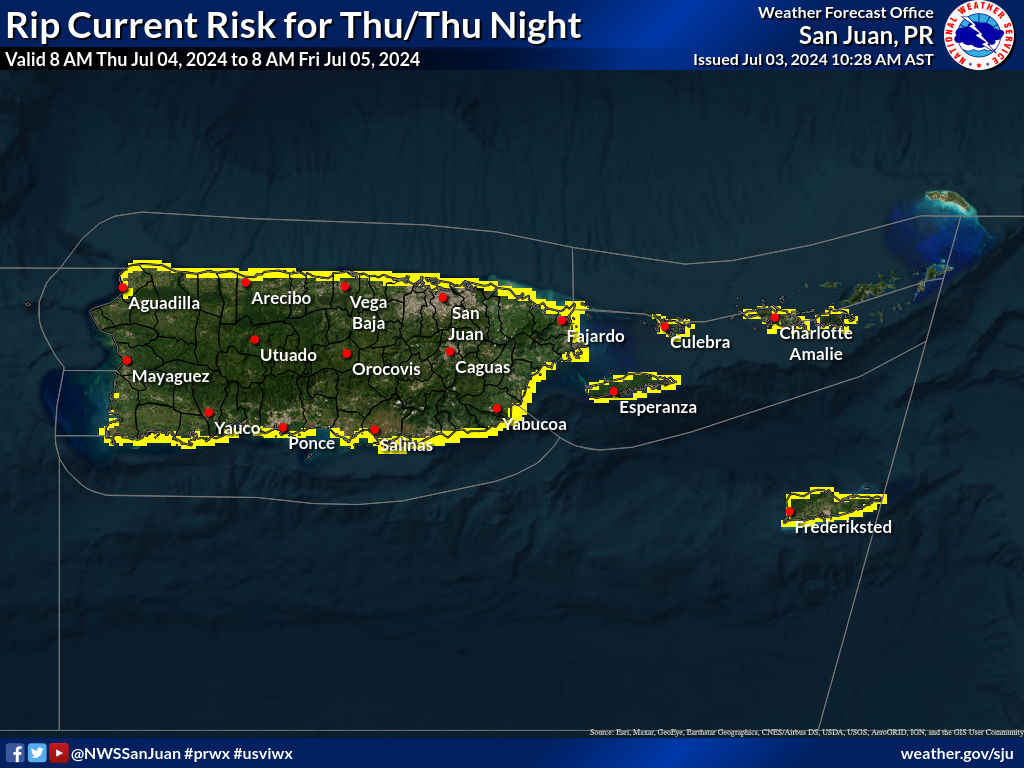
Clear = Low Rip Current Risk, Yellow = Moderate Rip Current Risk, Red = High Rip Current Risk
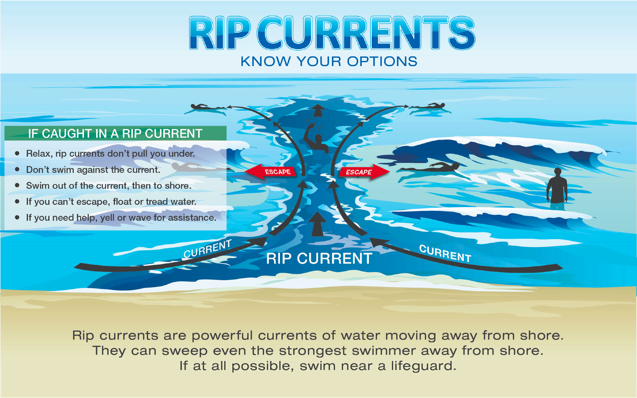
Learn more about rip current safety in an interview between the NWS and the VI Source here.
TROPIC WATCH
Tropical Activity:
The National Hurricane Center (NHC) is monitoring several tropical disturbances, including Hurricane Beryl, as the storm continues to move across the Caribbean. Hurricane Beryl remains a dangerous, major hurricane moving toward the west-northwest and will impact areas including Jamaica and the Cayman Islands.
A tropical wave behind Beryl, dubbed “Invest 96L,” has a low chance of development. However, regardless of tropical development, inclement weather is forecast to occur across the USVI and Puerto Rico on Thursday. Please read more here.
Please follow the National Hurricane Center for the latest updates.
Article: NOAA Forecasts Above-Average 2024 Hurricane Season, Expects High Number of Named Cyclones
Click here to learn tips on being prepared during the 2024 Atlantic Hurricane Season.
Days Remaining in the 2024 Atlantic Hurricane Season: 149 Days
OBSERVATIONS
Sunrise: 5:49 a.m.
Sunset: 7:01 p.m.
Ocean water temperature: Approximately 86°F, approximately 30°C.
UV index: 10+ out of 10 (VERY HIGH)
Wednesday’s high temperature: 91°F, 32.7°C
Wednesday’s low temperature: 81°F, 27.2°C
Preparation for extreme weather events in the Caribbean, such as earthquakes and tropical cyclones, is important. Residents and visitors in the USVI are encouraged to stay updated on weather events on the V.I. Source Weather page and sign up for alerts from the National Weather Service and the Virgin Islands Territorial Emergency Management Agency.


