

The National Hurricane Center continues to monitor a developing tropical wave in the Atlantic. The disturbance is forecast to intensify into a tropical storm and pass near the U.S. Virgin Islands between Tuesday and Wednesday, and territory residents and visitors are urged to stay vigilant.
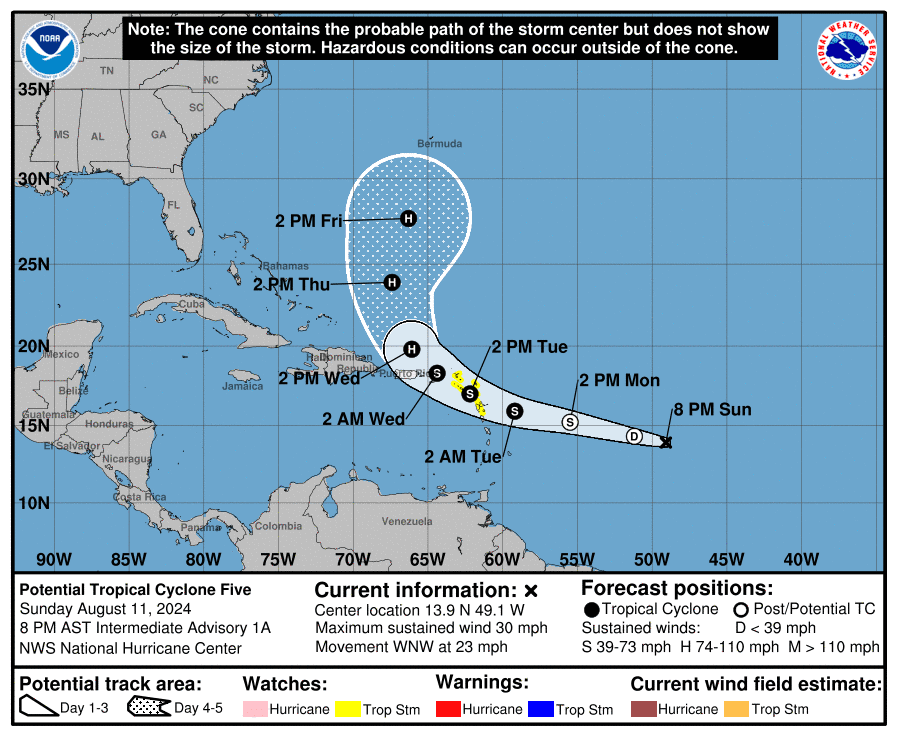
As of 8 p.m. on Sunday, the NHC explained that the tropical wave, currently called Potential Tropical Cyclone Five, is located approximately 875 miles to the east-southeast of Antigua and moving toward the west-northwest across the Atlantic at approximately 23 mph, packing winds of roughly 30 mph. While the system is not currently well-organized, it is forecast to intensify into a tropical storm over the next day or so, with maximum sustained winds of at least 39 mph before reaching the USVI. If the storm intensifies into a tropical storm, it will be given the name “Ernesto,” the fifth named cyclone of the 2024 Atlantic Hurricane Season.
“On the forecast track, the disturbance is expected to move across portions of the Leeward Islands on Tuesday and approach the U.S. and British Virgin Islands Tuesday night,” according to an update from the NHC on Sunday.
The NHC explained that the system is currently located in an area of moderate wind shear, which can be detrimental to developing cyclones. However, the storm is forecast to move into a region of reduced wind shear soon, possibly allowing for further strengthening over the next day or so.
Several tropical storm watches have been issued across portions of the Lesser Antilles. Additional weather alerts for the USVI and Puerto Rico may soon be issued.
“The disturbance is expected to become a tropical storm before reaching the Leeward Islands, where Tropical Storm Watches are in effect,” the NHC explained. “Tropical storm conditions could begin on Tuesday for portions of the area,” the NHC said.
A Tropical Storm Watch is in effect for Guadeloupe, St. Kitts, Nevis, Montserrat, Antigua, Barbuda, and Anguilla, Saba and St. Eustatius, St. Martin, [and] Sint Maarten,” the NHC said.
“A Tropical Storm Watch means that tropical storm conditions are possible within the watch area, generally within 48 hours, [and] interests elsewhere in the Leeward Islands, British and U.S. Virgin Islands, and Puerto Rico should monitor the progress of Potential Tropical Cyclone Five,” the NHC explained. “Additional watches could be required tonight or early Monday,” the NHC noted.
Potential Storm Impacts
The NHC has said that areas across the Caribbean, including the USVI and Puerto Rico, should expect deteriorating weather conditions early this week, including choppy seas, gusty winds, and rainfall.
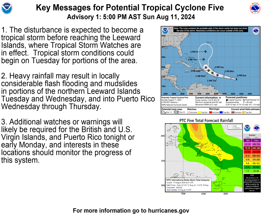
“Heavy rainfall may result in locally considerable flash flooding and mudslides in portions of the northern Leeward Islands Tuesday and Wednesday, and into Puerto Rico Wednesday through Thursday,” the NHC warned.
“Potential Tropical Cyclone Five is expected to produce total rain accumulations of four to six inches over the northern Leeward Islands,” the NHC said. “For Puerto Rico, three to six inches of rainfall, with maximum amounts of 10 inches, are expected,” the NHC added.
Hurricane Season and Being Prepared
The 2024 Atlantic Hurricane Season has been record-breaking, particularly due to destructive Hurricane Beryl, which rapidly intensified into a major hurricane and caused significant damage across the Caribbean and the U.S. state of Texas in July. (Rapid intensification remains a concern as the season progresses, highlighting the importance of preparing well before a storm arrives.)
As reported in a recent Source article, a busy 2024 season continues to be possible because of several factors, including a transition from an El Niño weather pattern to La Niña and extraordinarily warm sea surface temperatures across the North Atlantic. The combination of these elements may contribute to an increase in cyclones developing this year.
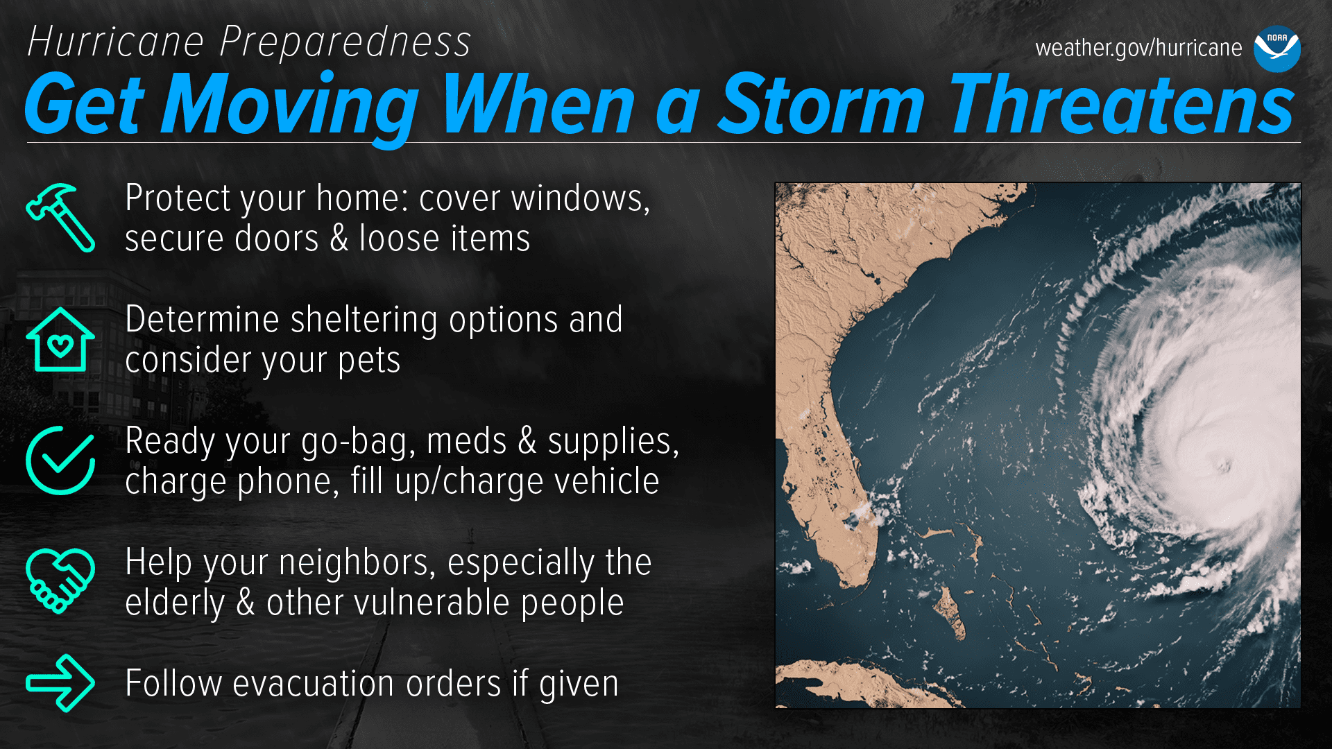
USVI residents and visitors are encouraged to follow this storm very closely and can find information regarding hurricane preparedness from the Virgin Islands Territorial Emergency Management Agency and the National Oceanic and Atmospheric Administration.
Weather Updates
The National Weather Service in San Juan, Puerto Rico, is expected to provide ongoing updates on the situation, and detailed information can be found on the NWS website. Weather forecast information, including severe weather alerts, is also available from the Virgin Islands Territorial Emergency Management Agency.
Additionally, the Source Weather Page publishes a daily weather forecast and offers readers the opportunity to view weather forecast videos and disaster preparedness video segments.


