

The U.S. Virgin Islands have endured sweltering heat this year, and the trend is forecast to continue as the peak of hurricane season arrives.
The Source spoke with meteorologists as well as officials from the V.I. Health Department and the V.I. Public Works Department to better understand the reasons for the ongoing heat and how individuals can stay safe. Meteorologists also provided a tropical update about what can be expected regarding cyclone development over the coming months.
Excessive Heat
Matt Rosencrans, a meteorologist at the National Oceanic and Atmospheric Administration’s (NOAA) Climate Prediction Center, shared details about the hot weather.
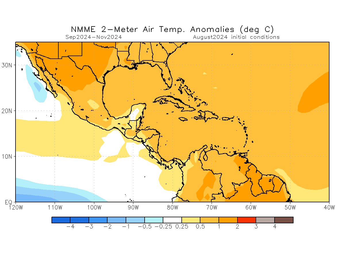
“Sea surface temperatures are very warm, [and they are] the second highest on record for the Atlantic and Main Development Region [between the area] stretching from Africa to the Caribbean, and warmest on record for the waters surrounding the Caribbean,” Rosencrans said. “[Combining] these warm sea surface temperatures with weaker trade winds sets the stage for air to feel stagnant and pick up a lot of energy from the oceans,” he explained.
“[Additionally,] the ‘low-level subtropical ridge’ [which is] an area of high pressure that is present year-round [and is positioned across the Atlantic] has been both stronger and farther north than normal, which can lead to less cloudiness near the islands,” Rosencrans stated.
“We expect warmer temperatures [to continue] over the islands, given the anomalously [warm] sea surface temperatures,” Rosencrans noted. “[Also,] the conditions of the atmosphere [have] led to a lack of afternoon thunderstorms to break the heat,” he said. “[Finally,] the lack of cloudiness on a large scale can support even warmer sea surface temperatures.”
While the temperatures across the region have been hot, it has felt even hotter due to a high “heat index.”
“The heat index, also known as the apparent temperature, is what the temperature feels like to the human body when relative humidity is combined with the air temperature,” according to the National Weather Service (NWS).
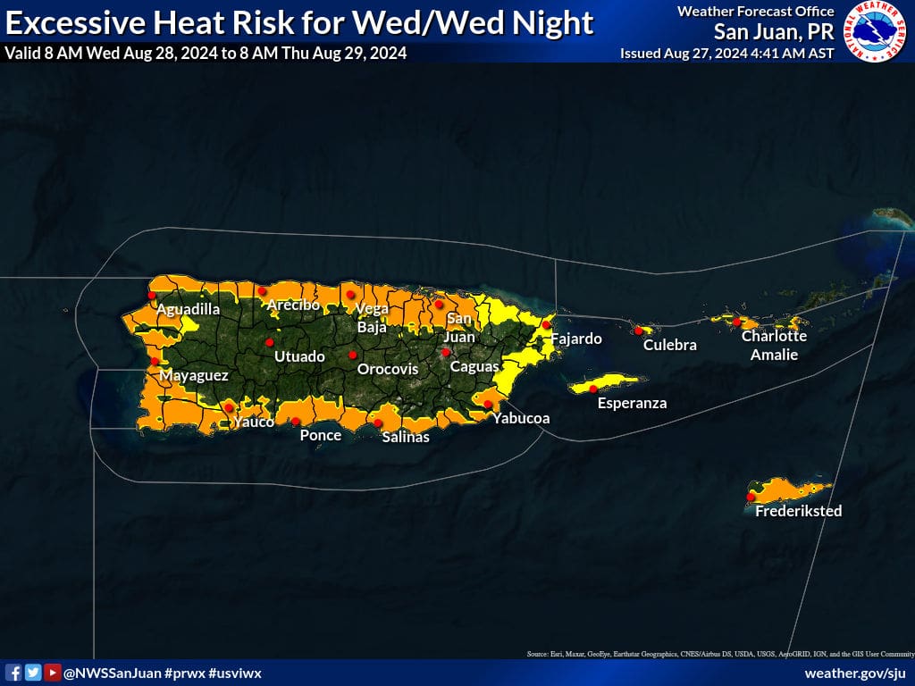
The NWS in San Juan, Puerto Rico, has regularly issued Heat Advisories and Heat Warnings for portions of Puerto Rico and the U.S. Virgin Islands over the last few months. The alerts provide residents and visitors with information about where the warmest temperatures are forecast to occur and the health problems that hot weather can cause.
Health Department Tips
Dr. Tai Hunte-Ceasar, chief medical officer of the V.I. Health Department spoke to the Source and offered suggestions for how residents and visitors across the USVI can remain safe and healthy during extreme heat.
“The VI Department of Health continues to monitor weather conditions, especially as we continue to be impacted by more frequent heat waves and excessive heat due to climate change,” Hunte-Ceasar said.
“We are most concerned with our seniors 65 and older, who are the most vulnerable to heat strokes and heat illnesses,” Hunte-Ceasar explained. “We continue to encourage our seniors and everyone to drink water, stay hydrated, and keep cool as much as possible,” she added.
“Besides our elderly, vulnerable populations include children and infants, construction workers or others who work outside or in the direct sunlight for extended hours, persons living with disabilities, and persons with chronic heart and lung conditions, especially those requiring oxygen,” Hunte-Ceasar noted.
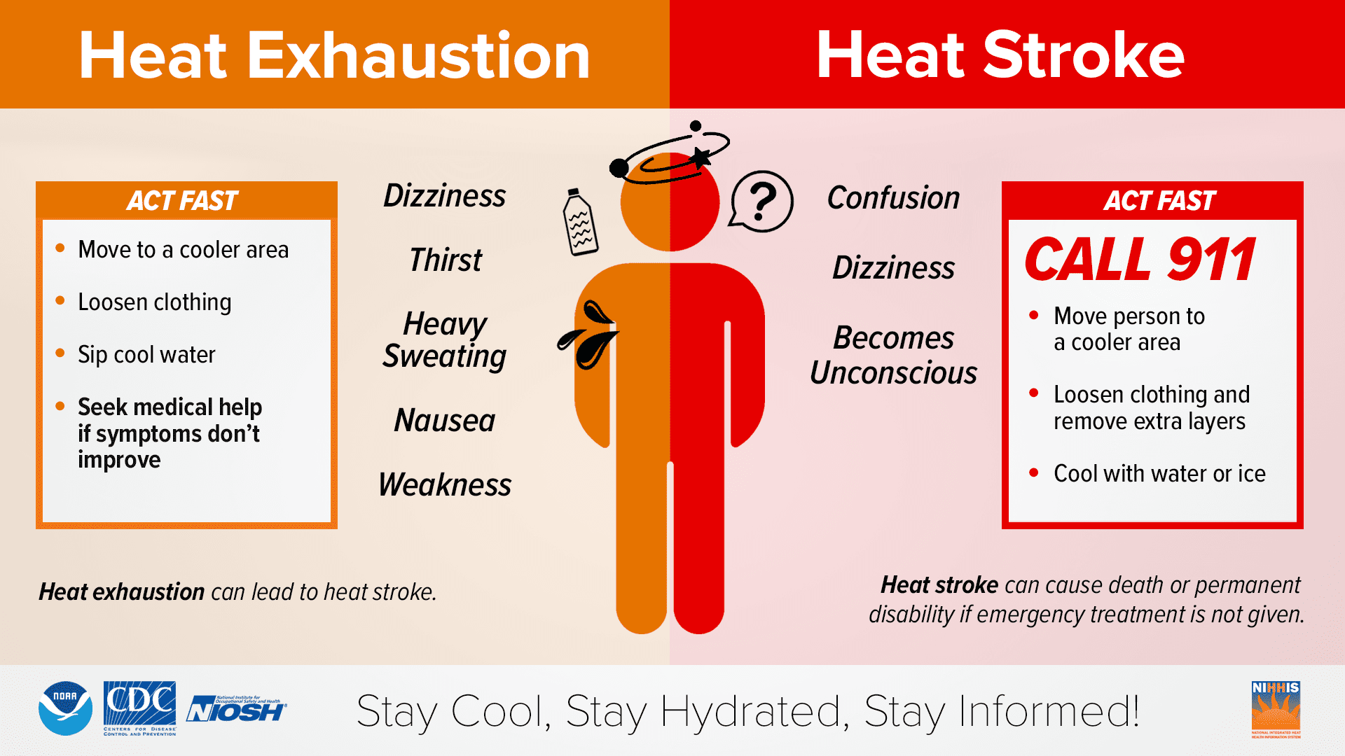
Hunte-Ceasar cited heat-related health problems that can arise from hot weather.
“Illness from heat-related illness can happen within minutes to hours of exposure, and they vary on a spectrum:
- Heat Rash: A red cluster of blisters that look like small pimples.
- Sunburn: Painful, red, and warm skin [with possible] blisters that eventually lead to skin peeling.
- Heat Cramps: [This condition causes] heavy sweating during intense exercise, muscle pain, or spasms.
- Heat Exhaustion: Heavy sweating, cold and clammy skin, nausea/vomiting, muscle cramps, weakness, fatigue, dizziness, headache, fainting.
- Heat Stroke: Fever; hot, red, dry, or damp skin; headache, dizziness, nausea, confusion, [and] passing out.”
To help avoid falling ill due to hot temperatures, Hunte-Ceasar offered the following advice:
- “Avoid being outdoors in the direct sun during the highest sun peak hours between 11 a.m. and 1 p.m.
- Use air conditioning or fans to keep your environment cool.
- If you are sweating, replace minerals with sports drinks, such as Gatorade.
- Wear cool clothing.
- Wear sunscreen if you are in the sun.
- Avoid hot and heavy meals during the hottest times of the day.
- Be mindful of the stove and oven use at home, especially if you don’t have air conditioning.
- Take cool showers or baths.
- Limit outdoor activities.
- NEVER leave children or pets in cars.
- If you work outdoors in the daytime, stay hydrated and drink water more frequently than usual. Do not wait until you are thirsty [to consume water]. Avoid sugary beverages to hydrate. Water is the best [option]!”
There are currently no cooling centers available across the territory. However, Hunte-Ceasar offered the following advice for individuals who may need access to air conditioning during prolonged periods of intense heat.
“There are no designated cooling centers,” Hunte-Ceasar said. “However, we recommend going to public air-conditioned spaces such as indoor malls or libraries,” Hunte-Ceasar stated.
Public Works Department Safety Information
The Source connected with Derek Gabriel, commissioner of the V.I. Public Works Department, to inquire about what safety measures are in place for DPW workers across the USVI. Gabriel explained that the health and safety of individuals is a top priority.
“We have been [attempting to adjust the hours that workers] are performing labor-intensive work [to avoid completing demanding tasks during the hottest hours of the day],” Gabriel stated. “We have been adding Heat Advisories [which are issued by the National Weather Service] to our Safety Briefings [which occur before work begins in the morning],” he said.
“We have [also] been making sure that [individuals] are aware [and alert] and that they are paying attention to their bodies and the signs [of possible heat-related illnesses],” Gabriel added.
Gabriel noted that DPW employees are provided adequate water daily and access to ice machines.
“We’re making sure that [work crews] are [staying hydrated],” Gabriel said. “All of the crews have access to five-gallon drums [of water], [and] ice machines [are available] so that the water is always cool,” he continued.
Gabriel also urged individuals to utilize Personal Protective Equipment (PPE) and not to work alone in case of a health emergency.
“Don’t work alone, and [try] to [use] the ‘buddy system’,” Gabriel said. “PPE [is extremely] important, [including] a hat, [protective] glasses, [sun] shades, [and] even in some cases, a hard hat, because it provides [some] protection from the sun,” he explained, while also reminding individuals to apply sunscreen.
Most importantly, Gabriel encouraged workers and the public to be mindful and proactive about their health, to take breaks, and drink lots of water.
“Be mindful of yourself [and your body], Gabriel advised. “A lot of times, [people] don’t realize that [they may be] working [themselves] into exhaustion,” he added.
Tropical Update
In addition to the ongoing heat, weather experts continue to expect an active 2024 Atlantic Hurricane Season.
NOAA has previously warned that a very active Atlantic Hurricane Season is expected, and a Source article explains that the main reasons for the potentially explosive season involve 1) a transition from an El Niño weather pattern to La Niña, likely reducing hurricane-shredding wind shear across the Atlantic, and 2) the record-breaking warm sea surface temperatures across the North Atlantic Ocean.
“There is a 66 percent chance for La Niña to emerge [between] September [and] November,” according to Nick Novella, a meteorologist at NOAA’s Climate Prediction Center.
“With respect to tropical cyclones, the large-scale environment, sea surface temperatures, and climatology are still supportive for tropical cyclone development in the coming weeks,” Novella warned. “[Additionally], a southward shift in the Inter-Tropical Convergence Zone, which is a belt of rising air and trade winds that encircles the Earth’s lower atmosphere near the equator, [toward] its more [typical] position can make the formation of tropical cyclones more likely,” he added.
Novella explained that high amounts of Saharan dust may be helping to create a pause in the tropical activity across the Atlantic.
“One theory for the lull in tropical cyclone activity in the Caribbean and the Atlantic is the dispersion of African dust, or the Saharan Air Layer, which is a mass of dry, dusty air that forms over the Saharan Desert and can cross over the Atlantic,” Novella stated. “This warm, dry, dusty air can inhibit tropical cyclone development as it is associated with dryness that can impact the energy needed for a tropical cyclone to form.”
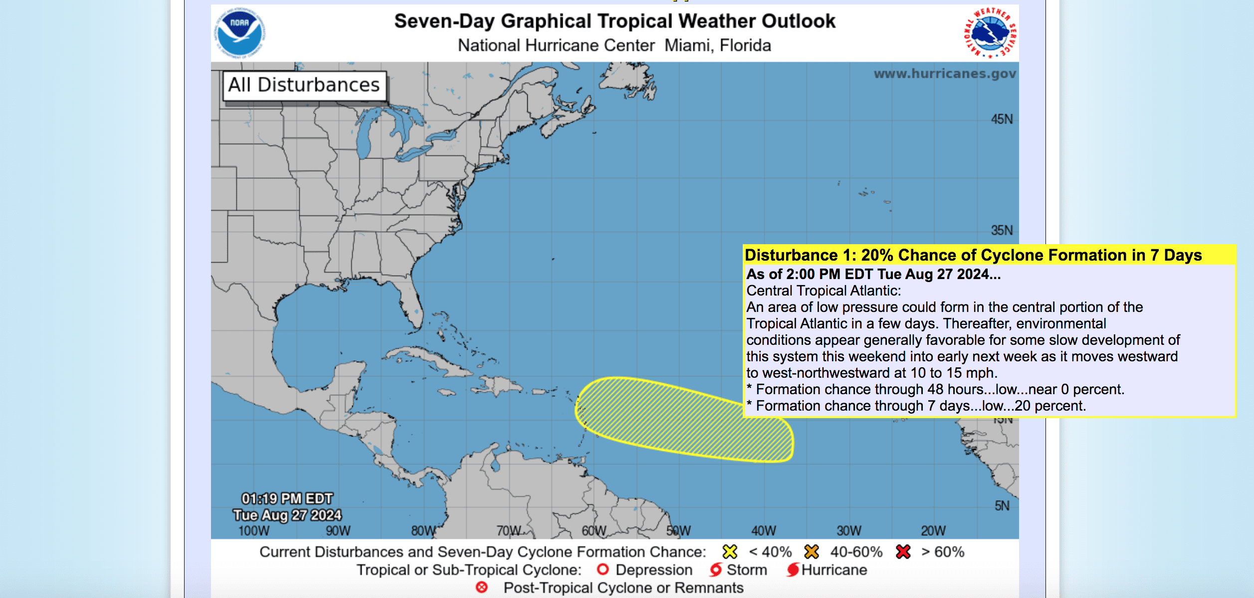
As of Tuesday evening, the National Hurricane Center is monitoring an area across the Central Atlantic for possible cyclonic development. While uncertainty is still high, residents and visitors across the territory are encouraged to monitor this situation closely.
VI Source Daily Weather Updates
Weather information, including forecasts regarding excessive heat, are available from the Virgin Islands Territorial Emergency Management Agency and the National Weather Service.
The Source Weather Page also publishes a daily weather forecast based on the predictions from the NWS, and offers readers the chance to view weather forecast videos and disaster preparedness video segments.


