

The National Weather Service (NWS) in San Juan, Puerto Rico, has warned that the U.S. Virgin Islands and Puerto Rico can expect more wet weather over the coming days as well as hazardous marine conditions. Additionally, the National Hurricane Center (NHC) continues to monitor the tropics regarding cyclonic development.
“Wet and unstable weather conditions are expected to continue into the next few days,” according to an update from the NWS on Wednesday. “The main [weather] feature [causing the unstable conditions] will be a deepening upper-level trough [an area of low pressure] and plenty of moisture [passing] across the islands,” continued the update.
In addition to the passage of an upper-level trough helping to maintain inclement weather, the NWS has noted that an area of low pressure may develop and move over or near the USVI and Puerto Rico by Thursday. The tropical disturbance, called Disturbance #1, is being monitored for potential cyclonic development.
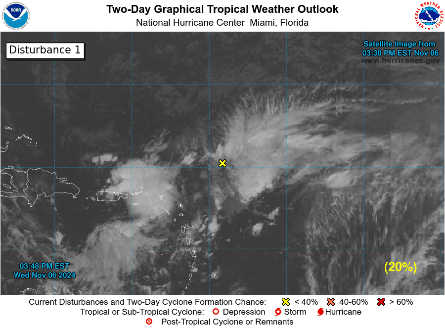
“A trough of low pressure is producing an area of disorganized showers and thunderstorms a couple hundred miles east-northeast of the northern Leeward Islands,” according to an update from the NHC on Wednesday. “This system is expected to move generally westward during the next few days, and an area of low pressure could form near the northern Leeward Islands or Virgin Islands [on Wednesday night] or Thursday,” the NWS said.
“Afterward, some gradual development of this system is possible toward the end of the week and into the weekend while it moves near or to the north of the Virgin Islands and Puerto Rico and approaches the southeast Bahamas,” the NHC added.
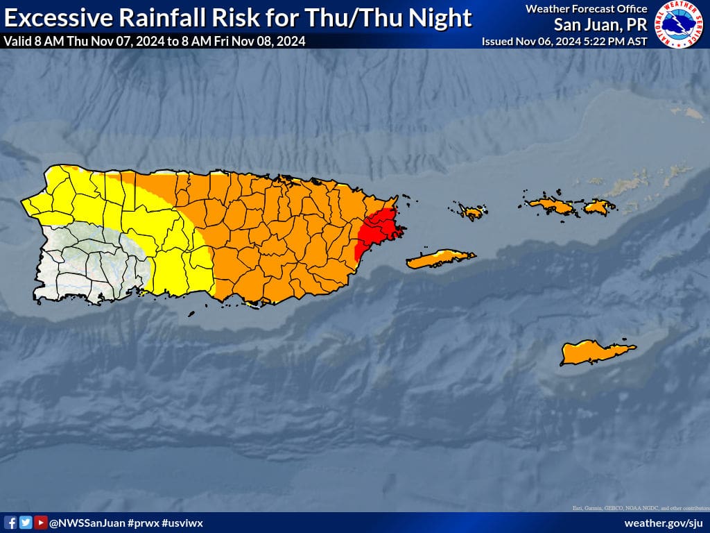
Regardless of development, the NWS anticipates rainfall, thunderstorms, gusty winds, and choppy seas across both U.S. territories.
“[There will be] the potential for flooding rains, hazardous seas, [a] high risk of rip currents, and breezy to windy conditions [that] will continue over the next few days,” the NWS explained. “Warm [temperatures] will [occur] at times.”.
A Small Craft Advisory and a High Rip Current Risk will be in effect for portions of the USVI and Puerto Rico until at least Friday. Wave heights are forecast to reach up to eight to 12 feet and possibly up to 15 feet.
Hurricane Rafael Heads for Gulf of Mexico; Additional Development Possible
In addition to Disturbance #1, the NHC is following Hurricane Rafael, located near the Gulf of Mexico. Rafael, the 17th named cyclone of the 2024 Atlantic Hurricane Season, is moving into the Gulf of Mexico and has impacted areas including Jamaica, the Cayman Islands, and Western Cuba.
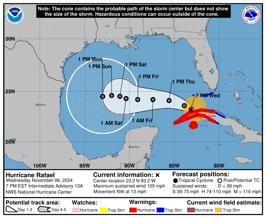
As of 8 p.m. AST, Rafael was packing maximum sustained winds of 105 mph and was moving to the northwest at 13 mph. After the hurricane enters the Gulf of Mexico, conditions are expected to become less favorable for intensification, and the cyclone is forecast to weaken. Still, the NHC noted that there is still uncertainty about the storm’s track and intensity. Residents and visitors across the Gulf of Mexico should closely monitor the situation.
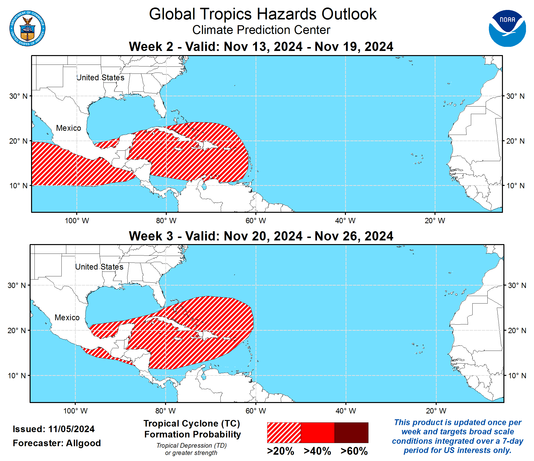
Finally, the Climate Prediction Center’s Global Tropics Hazards Outlook depicts an elevated chance of cyclonic development over the next few weeks. Hurricane season officially ends on Nov. 30, and the most recent system to directly affect the USVI this year was Tropical Storm Ernesto, which lashed the territory in August.
This year’s hurricane season has been record-breaking, including the explosive development of Hurricane Milton in the Gulf of Mexico at the beginning of October, the extremely high storm surge associated with Hurricane Helene across the southeastern USA in September, and destructive Hurricane Beryl, which rapidly intensified into a major hurricane and brought devastating impacts to portions of the Caribbean in July.
USVI residents and visitors are reminded that the weather forecast can change quickly, and it is essential to stay up to date with forecasts from the NHC. Hurricane preparedness tips are available from the Virgin Islands Territorial Emergency Management Agency and the National Oceanic and Atmospheric Administration.
Weather Updates
Weather forecast details, including severe weather alerts, are available from the VITEMA website and the National Weather Service.
The Source Weather Page also publishes a daily weather forecast and offers readers the opportunity to view weather forecast videos and disaster preparedness video segments


