
Powerful earthquakes on June 24 rocked Venezuela and briefly prompted the issuance of a Tsunami Advisory for Puerto Rico and the U.S. Virgin Islands. While the advisory was canceled, experts say the event serves as an important reminder that Caribbean earthquake and tsunami preparedness must be understood.
The Caribbean sits along active plate boundaries capable of producing damaging earthquakes and, in certain circumstances, tsunamis. Earthquakes and tsunamis do not arrive like hurricanes, with days of forecast tracks and preparations. In some scenarios, especially with a nearby earthquake, coastal communities may have only minutes to respond.
For the USVI and Puerto Rico, experts said the Venezuela seismic activity does not mean a major local earthquake is now more likely. However, they also said the event underscores why residents and visitors should understand the difference between an advisory and a warning, review evacuation routes, and know the natural warning signs of a tsunami.
To better understand what happened in Venezuela and what it means for the region, the Source connected with the Virgin Islands Territorial Emergency Management Agency, the U.S. Geological Survey, and the University of the West Indies Seismic Research Centre.
USGS: The Venezuela Quakes Occurred in a Known Area of Active Faulting
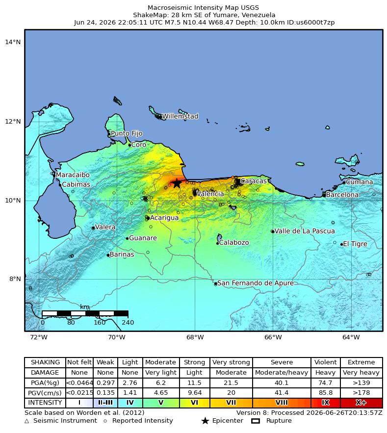
Christopher DuRoss, a research geologist with the U.S. Geological Survey in Golden, Colorado, provided the Source with detailed information about the earthquakes. He said the Venezuela sequence included two major earthquakes within seconds of each other in an active fault area along the boundary between the South American and Caribbean plates near Caracas, the capital of Venezuela.
“Venezuela experienced a magnitude 7.2 foreshock followed 39 seconds later by a magnitude 7.5 mainshock,” DuRoss said. “The epicenters of the two earthquakes are located about 10 km apart and about 175 km west of Caracas. The earthquakes occurred in a known area of active faulting, where right-lateral strike-slip faults form a complicated boundary between the South America and Caribbean plates.”
The earthquakes had severe impacts in Venezuela, and aftershocks have continued to rock the region as recently as June 29. The USGS Prompt Assessment of Global Earthquakes for Response system issued a red alert for the magnitude 7.5 event, stating, “High casualties and extensive damage are probable, and the disaster is likely widespread.”
DuRoss explained that the earthquakes occurred in the southern Caribbean, where the Caribbean plate is moving eastward and interacting with nearby plates and fault systems.
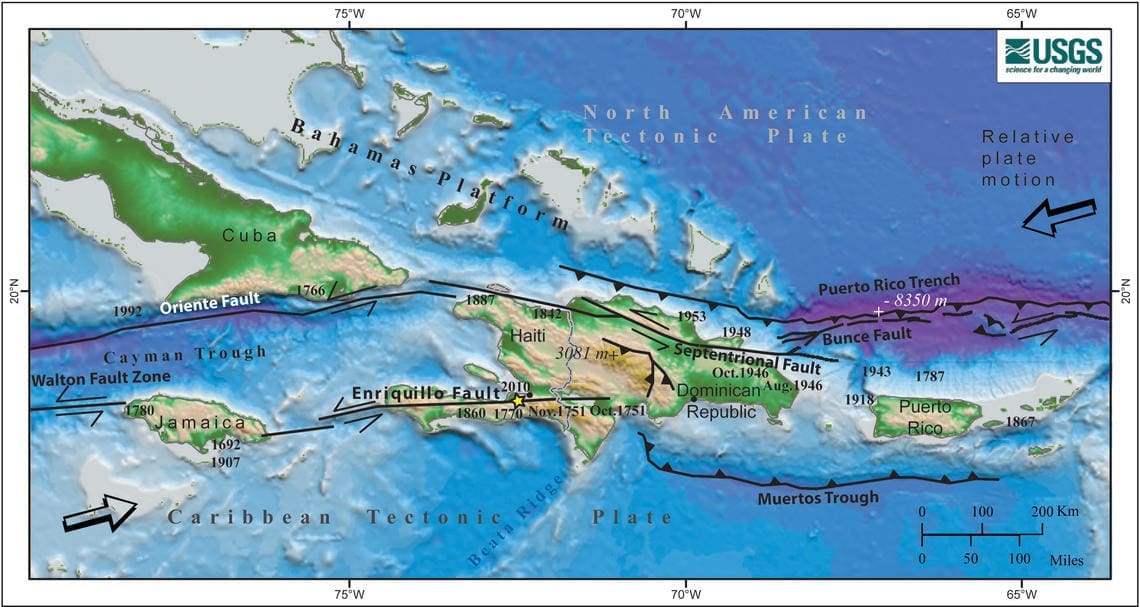
The recent earthquakes in Venezuela occurred along faults that accommodate eastward motion of the Caribbean plate. The earthquakes were right-lateral strike-slip earthquakes, where the Earth’s crust moved to the right from an observer on one side of the fault. In the eastern Caribbean, a convergent plate margin, which is a subduction zone forming the Puerto Rico trench, creates an earthquake hazard for Hispaniola, Puerto Rico, the Virgin Islands, and the Lesser Antilles. Subduction zone earthquakes can be large, up to magnitude 8+, and devastating, and seafloor uplift or subsidence can generate tsunamis with far-reaching effects on coastal communities.
Why a Large Earthquake Does Not Always Mean a Large Tsunami
After the quakes struck Venezuela, a Tsunami Advisory was issued for Puerto Rico and the USVI. DuRoss said tsunami generation depends on more than earthquake magnitude. The type of fault movement, the location of the rupture, and whether the seafloor moves vertically are all important factors.
“Tsunami generation is more likely to occur when substantial vertical motion of the seafloor occurs during an earthquake,” DuRoss clarified. “This is more likely to happen in large reverse or thrust earthquakes, for example at a convergent boundary or subduction zone. Examples of tsunami generating earthquakes include the 2004 magnitude 9.1 Sumatra–Andaman earthquake and the 2011 magnitude 9.1 Tohoku, Japan earthquake. More information can be found here.”
The Venezuela earthquakes occurred along strike-slip faults. That type of motion is generally less likely to generate a tsunami, but DuRoss said it does not completely eliminate the possibility.
“The earthquake in Venezuela occurred along strike-slip faults, where the earth’s crust moves horizontally. Strike-slip earthquakes are less likely to generate tsunamis. However, because these faults continue offshore, they can still vertically displace the seafloor, and tsunami generation is possible. These earthquakes are an important reminder that the region is seismically active,” said DuRoss.
VITEMA: Tsunami Sirens Are Activated for Tsunami Warnings, Not Advisories
Regina Browne, deputy director of planning and preparedness with VITEMA, spoke with the Source along with J’Lisa Martinez, public information officer with the agency. Browne explained that the tsunami sirens across the USVI are not activated for every tsunami alert product.
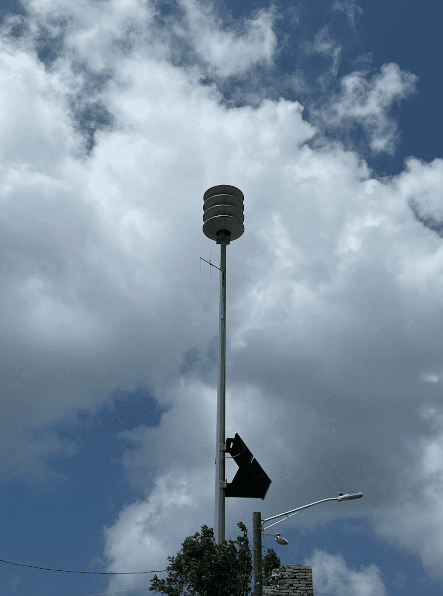
“The sirens in the territory are only activated for a Tsunami Warning. Because we were under a Tsunami Advisory on June 24, that would not have prompted us to activate the sirens throughout the territory.”
Browne explained that a warning indicates a more serious and urgent threat than an advisory.
“When a Tsunami Warning is issued, that is when a tsunami threat is imminent. It can happen very quickly.”
Tsunami Alerts
According to the National Weather Service, various tsunami alerts are issued when a threat arises.
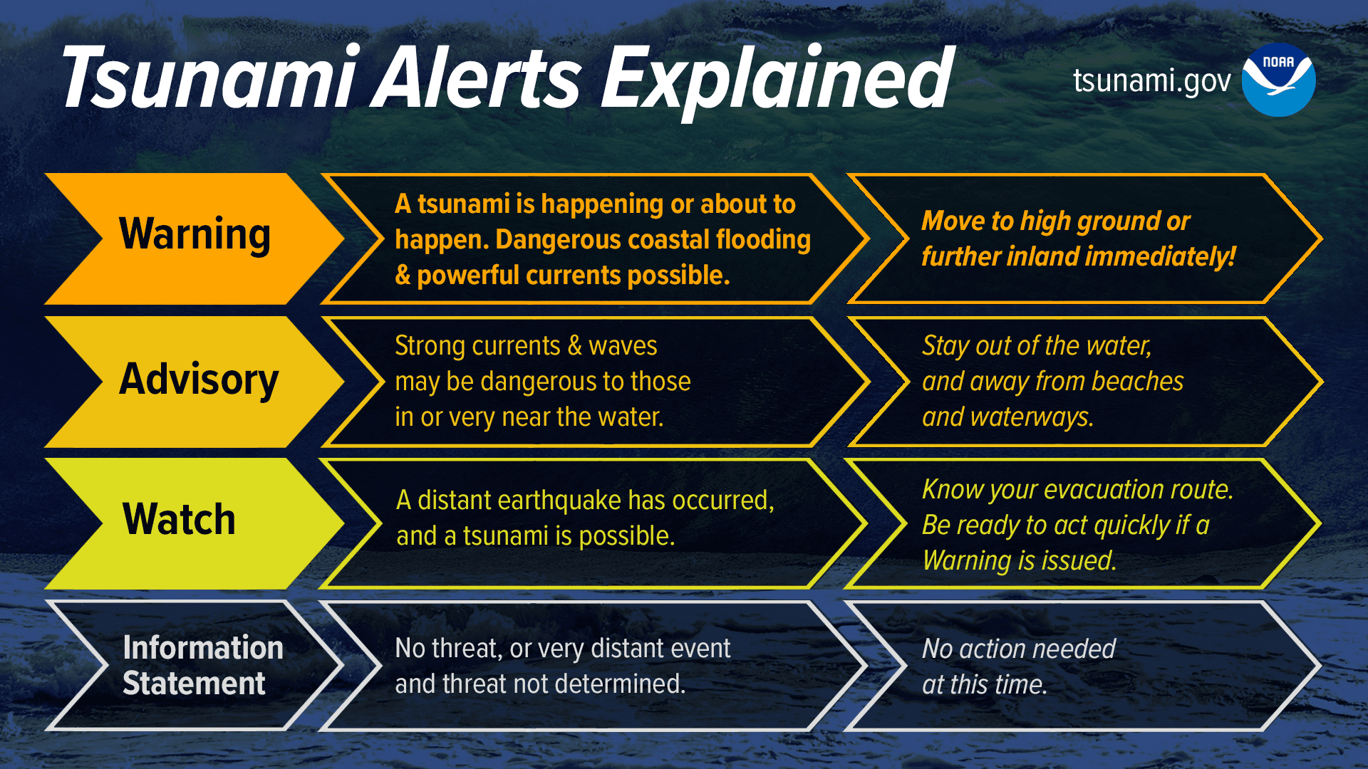
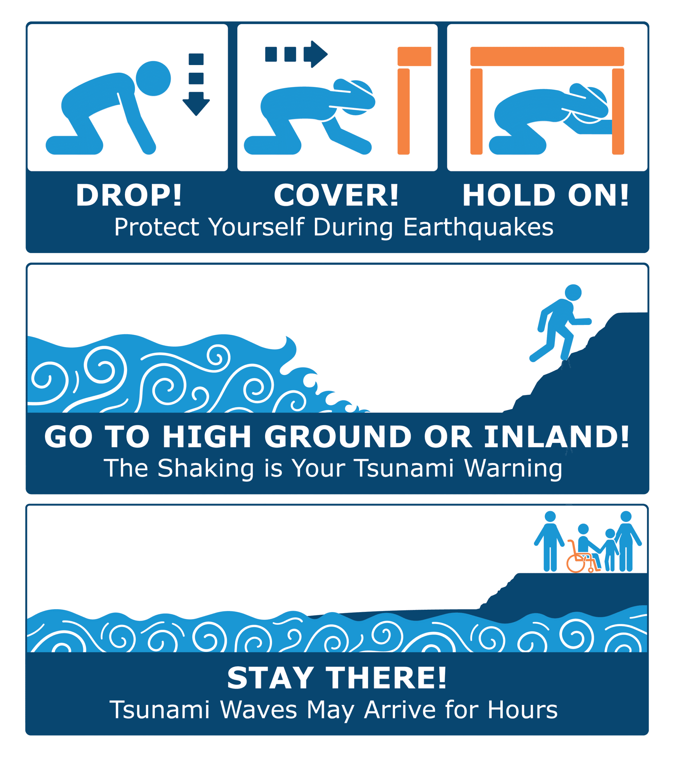
“Tsunami Warning: Take Action – Danger! A tsunami that may cause widespread flooding is expected or occurring. Dangerous coastal flooding and powerful currents are possible and may continue for several hours or days after initial arrival. Follow instructions from local officials. Evacuation is recommended. Move to high ground or inland (away from the water).
“Tsunami Advisory: Take Action—A tsunami with potential for strong currents or waves dangerous to those in or very near the water is expected or occurring. There may be flooding of beach and harbor areas. Stay out of the water and away from beaches and waterways. Follow instructions from local officials.
“Tsunami Watch: Be Prepared: a distant earthquake has occurred. A tsunami is possible. Stay tuned for more information. Be prepared to take action if necessary.
“Tsunami Information Statement: Relax – An earthquake has occurred, but there is no threat or it was very far away, and the threat has not been determined. In most cases, there is no threat of a destructive tsunami.”
VITEMA’s tsunami preparedness page also emphasizes that residents should review evacuation information before an event happens. The same VITEMA page includes evacuation maps for St. Croix, St. John and St. Thomas and urges residents to move quickly if a tsunami threat develops.
UWI Seismic Research Centre: Significant, But Not Unexpected
Dr. Erouscilla P. Joseph, director of the University of the West Indies Seismic Research Centre in St. Augustine, Trinidad, said the Venezuela earthquakes were substantial but not surprising.
According to Joseph, “The recent earthquakes were significant but not unexpected given the tectonic setting of northern Venezuela. This region lies along the active boundary between the Caribbean and South American tectonic plates and has produced numerous damaging earthquakes throughout history.
“The sequence was noteworthy, because it involved two large earthquakes occurring approximately 39 seconds apart – a magnitude 7.2 followed by a magnitude 7.5. This suggests a complex rupture process involving multiple fault segments or cascading fault rupture. While such sequences are relatively uncommon, they are well documented globally and reflect the complexity of how stress is released during major earthquakes.”
Joseph said the event should not be interpreted as a sign that Puerto Rico or the USVI now face a heightened immediate earthquake threat.
“While a large earthquake changes stress locally, there is currently no evidence that this event has increased the immediate likelihood of a major earthquake in Puerto Rico or the Virgin Islands. However, the event serves as an important reminder that earthquakes can occur throughout the Caribbean, and preparedness should remain a regional priority.”
Why the Advisory Was Issued and Later Canceled
“A Tsunami Advisory was issued for Puerto Rico and the U.S. Virgin Islands because the magnitude and location of the earthquake warranted further evaluation. Small tsunami waves were subsequently observed at several sea-level stations in the northeastern Caribbean, confirming that the earthquake had generated a tsunami. However, observations from coastal tide gauges and deep-ocean tsunami detection buoys showed that the waves remained small and did not pose a significant hazard to the region. As additional data became available and forecast models were confirmed by observations, the advisory was canceled,” Joseph said.
Joseph cautioned that advisories are important, even when they are later canceled.
“This event illustrates why tsunami advisories should be taken seriously. The initial seismic information tells us that a tsunami is possible, but it is the combination of seismic analysis, forecast modeling, and real-time sea-level observations that allows warning centers to determine whether the tsunami poses a significant threat, and when it is safe to cancel the advisory.”
A Shared Regional Responsibility
Joseph explained that the Venezuela earthquakes should be understood as part of a broader regional hazard that requires continued monitoring, public education, and preparedness across the Caribbean.
“One of the key messages I would like readers to take away is that the Caribbean is an active tectonic region where earthquakes are a natural part of our geological setting. While this recent event occurred near Venezuela, it serves as a reminder that earthquake and tsunami preparedness is a shared regional responsibility. Continued investment in scientific monitoring, resilient infrastructure, effective warning systems, and public education is essential to reducing risk across all Caribbean territories,” Joseph urged.
Local Weather Updates
Across the U.S. Virgin Islands, local weather information is updated regularly on the Source Weather Page and on the official website of the National Weather Service in San Juan, Puerto Rico. USVI residents and visitors can also sign up for emergency alerts, including earthquake and tsunami notifications, from VITEMA.


