
The 2024 Atlantic Hurricane Season has already been busy, and the season’s peak is quickly approaching. The remainder of the season is forecast to be exceptionally active, and now is the time to prepare for storms that may impact the Virgin Islands.
The Source contacted Matt Rosencrans, National Weather Service lead hurricane seasonal forecaster, to obtain a mid-season update on what may be expected regarding tropical development for the remainder of the season. Rosencrans explained that meteorologists continue to anticipate numerous cyclones forming across the Atlantic and Caribbean.
“The National Oceanic and Atmospheric Administration is still expecting a busy hurricane season, with a total of 17-24 named storms,” Rosencrans said. “[This includes] 8-13 hurricanes, and 4-7 major hurricanes [a Category 3 cyclone or higher] for the season, [and] those totals include the four named storms, two hurricanes, and one major hurricane [that have already developed so far this year],” he said.
“[Therefore,] we are still expecting an additional 13-20 named storms, 6-11 hurricanes, and 3-6 major hurricanes,” Rosencrans added.

Notably, there is more confidence in the previous predictions calling for a hyperactive year across the tropics.
“We are more certain on an active season overall, [due to] the early season activity, largely from Hurricane Beryl [a major hurricane which caused widespread destruction in July],” Rosencrans stated. “[Because of the tropical activity that has already occurred this year,] it virtually eliminates the possibility of a below-normal season and minimizes the potential for even a near-normal season,” he continued.
For months, meteorologists and atmospheric scientists have been predicting a hyperactive season. A Source article explains that the main reasons for the potentially explosive season involve 1) a transition from an El Niño weather pattern to La Niña, likely reducing hurricane-shredding wind shear across the Atlantic and 2) record-breaking warm sea surface temperatures across the North Atlantic Ocean.
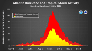
Peak Hurricane Season
Hurricane season runs each year from June 1 through November 30. However, based on tropical cyclone climatology, the National Hurricane Center explains that, “The peak of the Atlantic hurricane season is September 10, with most activity occurring between mid-August and mid-October.”
Rosencrans explained why this period can be very active for cyclone formation and why the month of September, in particular, can benefit brewing tropical waves.
“The factors that go into the development of a tropical storm and the intensification to a hurricane are most aligned during September,” Rosencrans said. “Atlantic sea surface temperatures are usually at their maximum for the year [which can help add fuel to a developing cyclone], Saharan dust has fallen from its peak [allowing for more moist air across the Atlantic], wind shear [which can shred a storm apart] is low, and the West African Monsoon with its associated African Easterly Waves has fully developed,” he stated.
“Historically, approximately 90 percent of the tropical storm and hurricane activity in the Atlantic happens during August, September, and October,” Rosencrans noted. “About 75 percent [of development occurs] after August 20th, so the Atlantic normally has quite a ramp-up in activity.”
The rapid intensification of cyclones can pose a significant threat to individuals living in the path of monster storms. There is a concern that this trend could continue as we move farther into peak season.
“Rapid intensification has a formal definition, [and] it [occurs] when a tropical cyclone’s maximum wind speed increases by at least 35 mph in 24 hours,” said Jake Carstens, a tropical meteorologist and assistant professor in the Department of Atmospheric Sciences at the University of North Dakota, in a previous Source interview. “The small-scale dynamics can be tricky in how this happens, but fundamentally, it is fueled by warm waters, a moist [humid] environment, and favorable upper-level winds,” Carstens continued.
“There have been hints of rapid intensification occurring more frequently in the Atlantic over the past 10 years, and a warming ocean/atmosphere adds to this potential,” Carstens stated. “Nonetheless, it remains a challenging aspect of hurricane forecasting due to both the small-scale features that influence it and the communication challenge of having little lead time to inform people in a storm’s path.”
Tropical Wave Now Headed Toward Caribbean
Almost like clockwork, the National Hurricane Center is monitoring a robust tropical wave as it travels across the Atlantic and toward the Caribbean. While uncertainty is still high, the disturbance may bring inclement weather to areas including the V.I. next week. Residents and visitors across the territory are encouraged to monitor this situation closely.
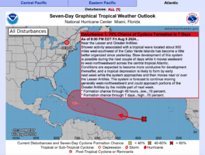
“Based on the NHC`s outlined potential formation area, and regardless of tropical development, the current forecast for Puerto Rico and the Virgin Islands indicates a significant deterioration in weather conditions beginning Tuesday afternoon and continuing through at least early Thursday morning, raising concerns regarding flooding risks,” according to an update on Friday from the NWS in San Juan, Puerto Rico. “However, it is still too early to determine the potential tropical cyclone-related impacts on Puerto Rico and the Virgin Islands, such as winds or storm surges, due to ongoing uncertainties about the system’s development and evolution,” the NWS said.
Prepare for Severe Weather Early
The NWS stressed that it is essential to be prepared and offered the following suggestions for individuals across the region.
“We urge the public to remain vigilant and monitor updates on the system’s evolution from official sources through their websites and social media platforms,” the NWS advised. “Take this opportunity to review your tropical emergency plan, including developing an evacuation strategy, assembling disaster supplies, creating a communication plan, and securing your home,” the NWS continued.
Rosencrans also reiterated the need for residents and visitors to plan early and not to wait until the last minute. He emphasized that early planning is key to ensuring safety and reducing storm impacts.
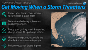
“Prepare now, [and] make plans for how to shelter or evacuate [if necessary, during hurricane season],” Rosencrans said. “If sheltering, follow guidance from local emergency management officials, [and obtain] some extra water and food and other supplies if you can, as [supplies] can take many days [to arrive] in the islands,” he explained. “For travelers, travel insurance can go a long way to blunting the impact of a disruption.”
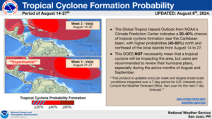
In addition to the current tropical wave being monitored, the Climate Prediction Center’s Global Tropics Hazard Outlook has predicted an increased potential of cyclonic development during Aug. 14-20 and Aug. 21-27.
“A number of factors play into that [tropical] outlook,” Rosencrans stated. “The ocean temperatures are likely to still be warmer than normal, a surge in the West African Monsoon is likely to support a period of enhanced African Easterly Waves, and the upper atmosphere is likely to be more favorable for [cyclonic] development as well,” he continued. “There is some disagreement in the modeling systems as to exactly where tropical storm development could occur, but the two key modeling systems we use both indicate enhanced odds for tropical formation.”
VI Source Daily Weather Updates
Additional information regarding hurricane preparedness is available from the Virgin Islands Territorial Emergency Management Agency and the National Weather Service.
The Source Weather Page also publishes a daily weather forecast and offers readers the chance to view weather forecast videos and disaster preparedness video segments.


