

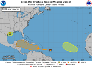
The National Hurricane Center (NHC) is monitoring several areas for possible cyclonic development. This week, a tropical wave designated “Disturbance #2” may create inclement weather for the Virgin Islands.
Disturbance #2 has been given a medium chance of development over the next seven days as it moves toward the Lesser Antilles. While the system is forecast to pass south of the Virgin Islands and Puerto Rico, moisture associated with the system may cause precipitation across the local islands starting Monday.
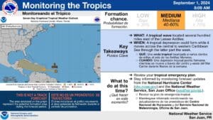
“At this time, late Sunday into Monday looks like the transitional days into a wetter pattern,” according to an update on Sunday from the National Weather Service in San Juan, Puerto Rico. “This gradual change in weather conditions will be associated with the tropical wave that the NHC continues to monitor near the Lesser Antilles and the Caribbean Sea, [and] the latest Tropical Weather Outlook keeps it in the medium range (40 percent) for development in the next seven days,” the NWS continued.
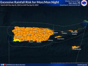
“At this time, the forecast models maintain the bulk of the moisture south of Puerto Rico and the U.S. Virgin Islands by Tuesday,” the NWS explained, “However, moisture and rainfall associated with this wave will reach the islands Monday into Tuesday, Tuesday being the wettest day of the period.”

Potential Impacts to the Virgin Islands and Puerto Rico
While the NWS has noted that the tropical wave is forecast to move south of the Virgin Islands, weather impacts are expected across the region.
“There is a risk of thunderstorms and urban and small stream flooding each day [this week, beginning on Monday],” the NWS stated. “[The] strong tropical wave is forecast to move south of the islands by Tuesday, increasing thunderstorm activity, winds, and seas,” the NWS said.
Stay Prepared During Hurricane Season
In addition to Disturbance #2, which may bring some impacts to the local islands, as of Sunday afternoon, the NHC is monitoring a tropical wave in the Gulf of Mexico and another wave in the Eastern Atlantic for signs of intensification.
The 2024 Atlantic Hurricane Season has already been record-breaking, particularly due to destructive Hurricane Beryl, which rapidly intensified into a major hurricane and brought devastating impacts to portions of the Caribbean in July.
As reported in a recent Source article, a busy 2024 season continues to be possible because of several factors, including a transition from an El Niño weather pattern to La Niña and extraordinarily warm sea surface temperatures across the North Atlantic. The combination of these elements may contribute to an increase in cyclones developing this year.
V.I. residents and visitors can find information regarding hurricane preparedness from the Virgin Islands Territorial Emergency Management Agency and the National Oceanic and Atmospheric Administration.
Excessive heat is forecast to continue across the area, and staying hydrated and cool is essential to help avoid heat-related illnesses.
Weather Updates
Weather forecast information, including severe weather alerts, is available from the VITEMA website and the National Weather Service.
The Source Weather Page also publishes a daily weather forecast and offers readers the opportunity to view weather forecast videos and disaster preparedness video segments.


