

The National Hurricane Center (NHC) has warned that Hurricane Helene, a major cyclone, will cause devastating impacts across a large swath of Florida and the southeastern U.S. Additionally, there will be an elevated risk of cyclonic development across the Atlantic Ocean in the coming weeks.
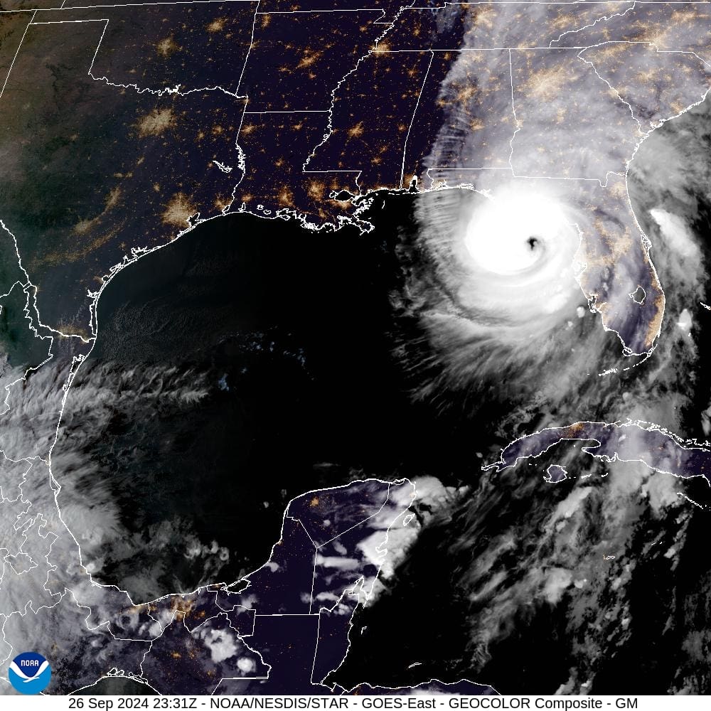
Hurricane Helene, a massive Category 4 system with tropical storm force winds extending over 300 miles from its core, is on track to make landfall late Thursday night along the Big Bend region of Florida near Tallahassee.
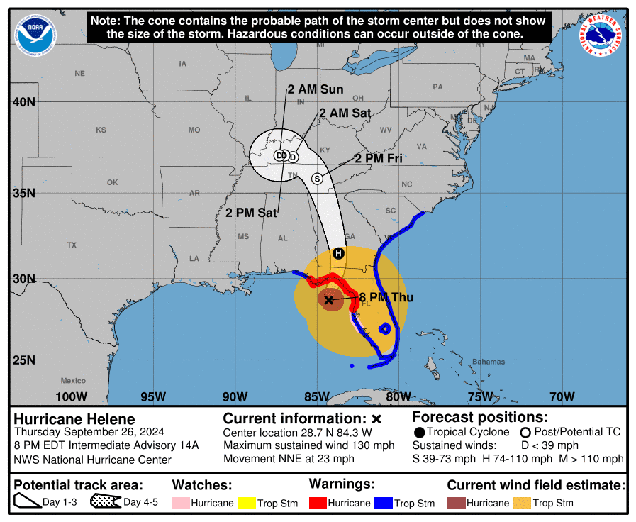
As of an 8:00 p.m. update from the National Hurricane Center, Helene was packing maximum sustained winds of 130 mph and moving to the north-northeast at 23 mph.
As Virgin Islanders know, in addition to powerful winds, water and storm surge can be especially dangerous during hurricanes. On Thursday, the National Hurricane Center described the storm surge along portions of Florida’s Big Bend coastline as rising up to 20 feet, potentially being “unsurvivable.”

Due to the cyclone’s large size, numerous tropical weather alerts have been issued for nearly the entire state of Florida and portions of Alabama, Georgia, and North and South Carolina. After the system moves inland, areas farther north, including Tennessee, are also expected to experience severe weather, such as the risk of flooding and tornadoes.
Travel between the southeastern United States and the U.S. Virgin Islands is likely to be disrupted by the severe weather, particularly at airports, including Hartsfield-Jackson International Airport in Atlanta, Georgia, but also throughout the Southeast, according to numerous reports, and fliers are encouraged to seek alternative travel days.
Additional Tropical Development Possible
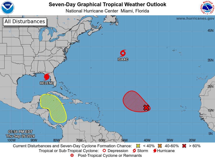
In addition to Helene, the NHC is monitoring several other disturbances, including Tropical Storm Isaac in the Northern Atlantic, a low-pressure system in the Eastern Central Atlantic called Invest 98L, and an area in the western Caribbean that may organize into a storm. (An “invest” is an area under investigation by the NHC for possible cyclonic development.)
While there is no imminent direct threat of cyclones to the USVI, the National Weather Service in San Juan, Puerto Rico, has explained that a tropical wave will pass close to the local islands on Friday, raising the risk of showers and thunderstorms.
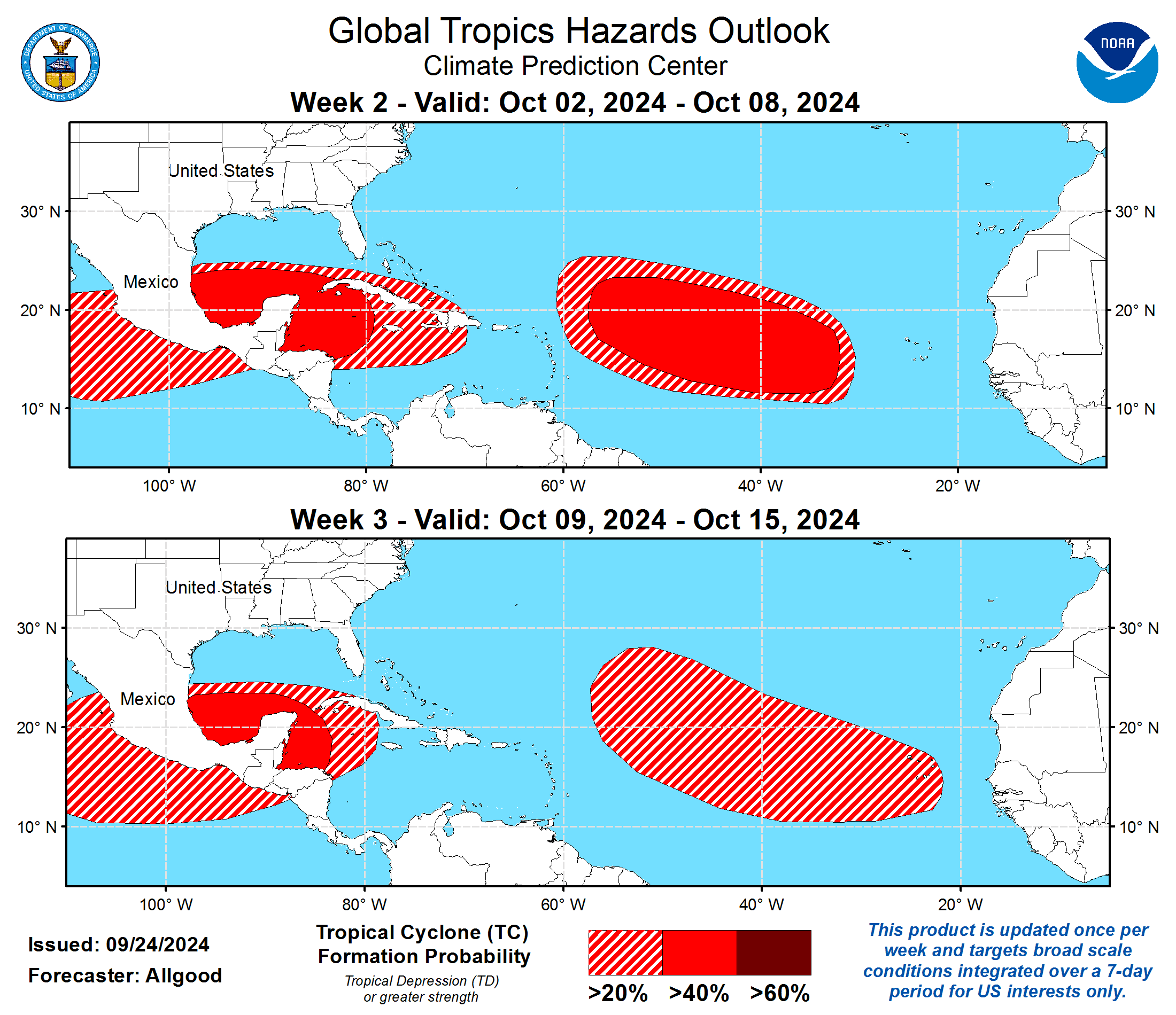
Notably, the Climate Prediction Center’s (CPC) Global Tropics Hazards Outlook indicates an increased chance of cyclone formation during the first half of October.
“[During the period between Oct. 2 and Oct. 8,] the highest probabilities for [cyclonic] development extend from the Bay of Campeche [near the Gulf of Mexico,] [and] eastward to the western Caribbean,” according to the CPC.
Additionally, the Main Development Region of the Atlantic, an area between western Africa and the Lesser Antilles, is also favored to remain active, with tropical cyclogenes is favored in the region between the Lesser Antilles and the Cape Verde Islands off the west coast of Africa, the CPC said. This enhanced activity may continue into the period between Oct.9 and Oct 15 though dynamical computer forecast model guidance becomes more diffuse, the CPC added.
Remain Prepared for Severe Weather
USVI residents and visitors are encouraged to stay up to date with forecasts from the NHC. Hurricane preparedness tips are available from the Virgin Islands Territorial Emergency Management Agency and the National Oceanic and Atmospheric Administration.
Weather forecast information, including severe weather alerts, is available from the VITEMA website and the National Weather Service.
The Source Weather Page also publishes a daily weather forecast and offers readers the opportunity to view weather forecast videos and disaster preparedness video segments.


