

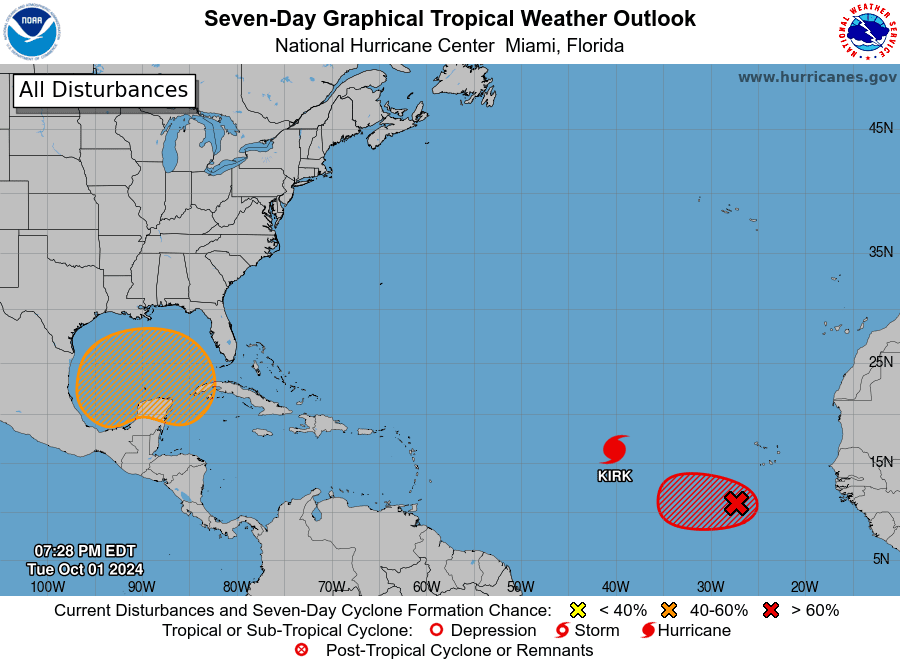
The National Hurricane Center is watching active areas of cyclonic development across the Atlantic Basin, including Hurricane Kirk in the Atlantic and two additional disturbances that have a chance of strengthening over the next seven days.
Kirk, a tropical cyclone that formed in the Eastern Atlantic on Monday and intensified into a hurricane on Tuesday, is expected to become a major hurricane later this week. Fortunately, the latest forecast track keeps the system out to sea and away from landmass.
Another tropical wave called Invest 91L, located behind Hurricane Kirk has a high chance of development over the next seven days, and a tropical depression is likely to form in the next couple of days. Currently, most computer forecast models also show the cyclone passing to the northeast of the USVI, but this is not guaranteed, and the storm track will become more evident in the coming days. (An “invest” is an area under investigation by the NHC for possible cyclonic development.)
The National Weather Service in San Juan, Puerto Rico, has noted that powerful swells generated by the two tropical disturbances may create rough seas across the local waters later this week.

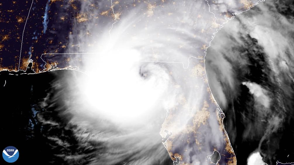
The NHC is also monitoring a disturbance near the Western Caribbean that has a medium chance of development as it moves toward the Gulf of Mexico. The potential system comes on the heels of major Category 4 Hurricane Helene that made landfall along the Big Bend region of Florida on Thursday, Sept. 26, and has caused numerous fatalities and catastrophic damage across the southeastern United States.
The 2024 Atlantic Hurricane Season has already been busy, and the remainder of the season, which officially ends on Nov. 30, is forecast to continue to be active.
Hurricane Season Expected to Remain Active
The Source contacted Matt Rosencrans, NWS lead hurricane seasonal forecaster, to obtain an update on what may occur regarding tropical development for the rest of the season. Rosencrans explained that meteorologists anticipate additional cyclones forming across the Atlantic and Caribbean.
“[Tropical] development is expected to continue through October,” Rosencrans stated. “The latest outlooks continue to indicate enhanced odds of tropical storm formation in the Western Caribbean and even higher odds out in the central and eastern Main Development Region (MDR) [which is an area of the Atlantic located between the west coast of Africa and the Lesser Antilles] through the next couple of weeks,” he said.
“Typically, [cyclonic] activity does ramp down quickly in the latter half of October, but during La Niña years, activity can extend further, [and] typical La Niña years have double the activity of El Niño years during November,” Rosencrans added.
During a La Niña cycle, the ocean waters across the equatorial Pacific Ocean cool significantly, affecting global weather. During La Niña, wind shear – a change in wind direction and velocity with height in the atmosphere – also typically decreases in the Atlantic Ocean. A reduction in wind shear can favor cyclone development. This pattern is the opposite of “El Niño,” a warming of the equatorial Pacific, which usually increases wind shear in the Atlantic Ocean, helping to rip apart storms and preventing hurricane formation and intensification. A cycle of El Niño has been occurring since June 2023.
“Scientists call [the two opposing climate patterns of El Niño and La Niña] the “El Niño-Southern Oscillation” (ENSO) cycle. El Niño and La Niña can both have global impacts on weather, wildfires, ecosystems, and economies,” according to NOAA.
Rosencrans explained the current chances of a La Niña developing, which has been predicted to occur for months.
“La Niña is favored to emerge [between] September [and] November [with a] 71 percent chance,” Rosencrans stated. “Some [of the] measures [that have been recorded] of ocean temperatures already have [indicated] La Niña conditions, [while] others are borderline,” Rosencrans continued.
“Typical La Niña years have double the [amount of tropical] activity of El Niño years during November,” he said. “Coupled with the warmer [than average] waters of the Atlantic, we are likely to have a more active October and November than in past years.”
Climate Prediction Center Anticipates More Cyclones
Indeed, a report from the Climate Prediction Center’s (CPC) Global Tropics Hazard Outlook on Tuesday indicated an increased risk of possible cyclonic development over the coming weeks, particularly through the first half of October.
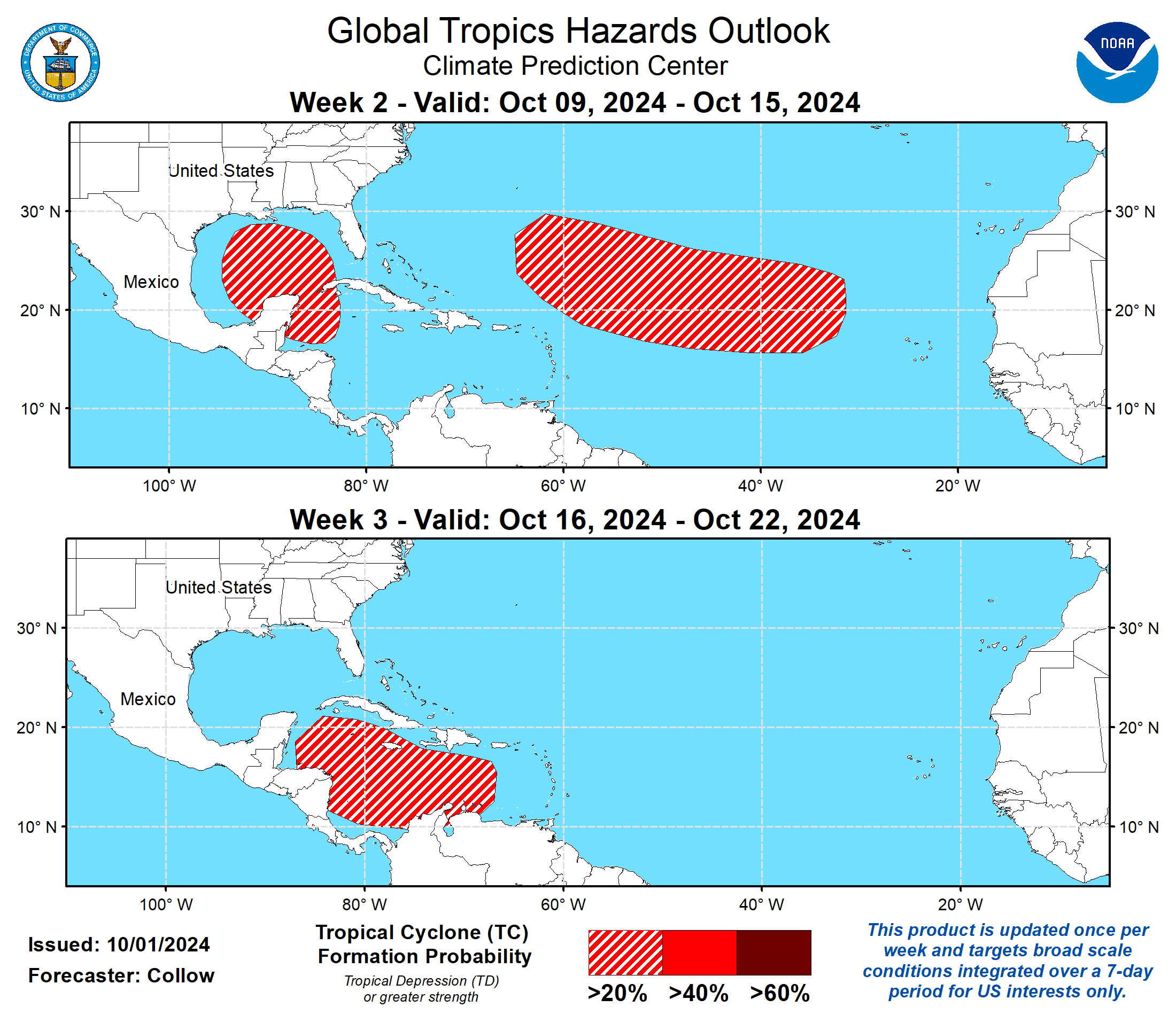
“Tropical Storm Kirk [which has now intensified into a hurricane] developed on Sept. 29 and is forecast to become a powerful hurricane over the open waters of the Atlantic,” according to the CPC. “The easterly [tropical] wave behind Kirk is strongly favored to develop into a tropical cyclone during [the period of Oct. 2 through Oct. 8],” the CPC said. “The NHC continues to monitor a tropical disturbance over the northwestern Caribbean that may develop into a tropical cyclone during [the same period or slightly later in the month],” the CPC continued.
“While tropical cyclone development in the MDR is favored to slow down due to the October climatology along with a more suppressed convective environment aloft, it is plausible to get an additional easterly wave to spin up into a tropical cyclone given how active it has been recently, favoring 20 to 40 percent chances for tropical cyclone development [from Oct. 9 through Oct. 15] over the MDR,” the CPC explained. “[From Oct. 16 to Oct. 22,] tropical cyclone development is most favored in the Caribbean, where a 20 to 40 percent chance is [expected], the CPC noted.
Remain Prepared Through Hurricane Season
“The hurricane season runs through Nov. 30, and in busy years, [storms can form] even beyond [the end of November],” Rosencrans warned. “[Therefore,] staying prepared will be key to helping stay safe,” he added.
“Hurricane Helene reminded us that we all need to stay prepared [for disasters], even those inland or at higher terrain, as hurricanes can impact [individuals] in many ways [and across many areas],” Rosencrans concluded.
Regardless of how many additional cyclones may form, the season has already been record-breaking, including with the extremely high storm surge associated with Hurricane Helene, as well as destructive Hurricane Beryl, which rapidly intensified into a major hurricane and brought devastating impacts to portions of the Caribbean in July.
USVI residents and visitors are reminded that the weather forecast can change quickly, and it is essential to stay up to date with forecasts from the NHC. Hurricane preparedness tips are available from the Virgin Islands Territorial Emergency Management Agency and the National Oceanic and Atmospheric Administration.
Finally, excessive heat is forecast to continue across the area, and staying hydrated and cool is essential to help avoid heat-related illnesses.
Weather Updates
Weather forecast information, including severe weather alerts, is available from the VITEMA website and the National Weather Service.
The Source Weather Page also publishes a daily weather forecast and offers readers the opportunity to view weather forecast videos and disaster preparedness video segments.


