

The National Hurricane Center is monitoring a tropical wave in the central Atlantic that has a moderate chance of developing later this week.
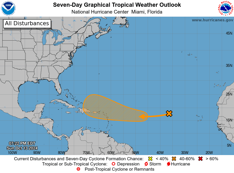
The disturbance, called Invest 94L, has been given a 40 percent chance of development over the next seven days as it moves across the Atlantic Ocean. As of 8 p.m. on Sunday, the system is moving through an area not conducive to cyclonic development. However, the NHC has reported that Invest 94L will encounter more favorable weather conditions for potential development during the middle to second half of the week. (An “invest” is an area under investigation for tropical development by the National Weather Service.)
“A well-defined area of low pressure located several hundred miles west of the Cabo Verde Islands is struggling to produce showers and thunderstorms,” according to an update on Sunday from the National Weather Service in San Juan, Puerto Rico.
“This system is currently embedded in an unfavorable environment and development is not anticipated over the next couple of days,” the NHC explained. “However, this [tropical wave] is forecast to move generally westward to west-southwestward, and environmental conditions could become more favorable for additional development by the mid to latter part of this week,” the NHC continued. “A tropical depression could form as the system begins moving west-northwestward and approaches or moves near the Leeward Islands by the end of this week,” the NHC added.

If Invest 94L eventually intensifies into a tropical storm with maximum sustained winds of at least 39 miles per hour, it will be named Nadine, the fourteenth named cyclone of the 2024 Atlantic Hurricane Season.
Remain Prepared During Hurricane Season
This year’s hurricane season has already been record-breaking, including the recent and explosive development of Hurricane Milton in the Gulf of Mexico at the beginning of October, the extremely high storm surge associated with Hurricane Helene across the southeastern USA in September, and destructive Hurricane Beryl, which rapidly intensified into a major hurricane and brought devastating impacts to portions of the Caribbean in July. Sadly, all three hurricanes resulted in extensive damage and numerous fatalities.
USVI residents and visitors are reminded that the weather forecast can change quickly, and it is essential to stay up to date with forecasts from the NHC. Hurricane preparedness tips are available from the Virgin Islands Territorial Emergency Management Agency (VITEMA) and the National Oceanic and Atmospheric Administration.
Other weather impacts forecast to affect Puerto Rico and the U.S. Virgin Islands include excessive heat throughout the week, and staying hydrated and cool is essential to help avoid heat-related illnesses. Additionally, powerful ocean swells generated by tropical systems in the Atlantic are expected to continue to reach the local islands through at least Monday, causing choppy seas and an elevated risk of rip currents.
Weather Updates
Weather forecast information, including severe weather alerts, is available from the VITEMA website and the National Weather Service.
The Source Weather Page also publishes a daily weather forecast and offers readers the opportunity to view weather forecast videos and disaster preparedness video segments.


