
The 2024 Atlantic Hurricane Season officially ends on Saturday, after a season that broke records and defied expectations. Ultimately, however, forecasters’ predictions regarding the amount of tropical development this year were verified to be accurate.
An end-of-hurricane season report released on Monday by the National Oceanic and Atmospheric Administration (NOAA) provided details about the activity observed.
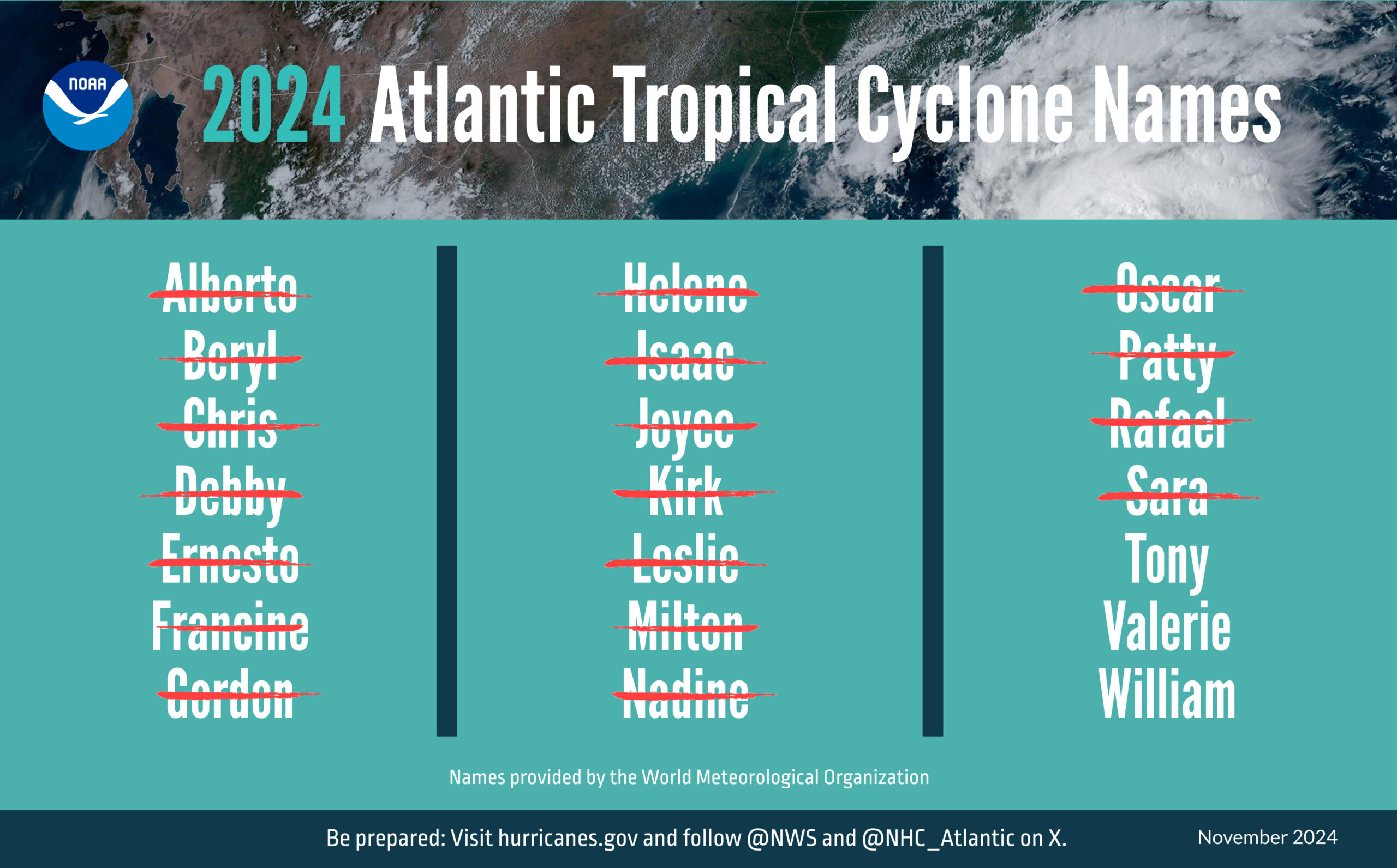
“The Atlantic basin saw 18 named storms in 2024 (winds of 39 mph or greater),” according to the NOAA report. “11 of those were hurricanes (winds of 74 mph or greater), and five intensified to major hurricanes (winds of 111 mph or greater),” the report continued.
“Five hurricanes made landfall in the continental U.S., with two storms making landfall as major hurricanes, [and] the Atlantic seasonal activity fell within the predicted ranges for named storms and hurricanes issued by NOAA’s Climate Prediction Center (CPC) in the 2024 August Hurricane Season Outlook,” NOAA said. “An average season produces 14 named storms, seven hurricanes, and three major hurricanes,” NOAA continued.
The NOAA document reported that a record number of storms developed after the peak of hurricane season, which occurs around the beginning of September each year.
“12 named storms formed after the climatological peak of the season in early September, [and] seven hurricanes formed in the Atlantic since Sept. 25 — the most on record for this period,” NOAA stated.
A Mid-Season Lull
Before the start of hurricane season on June 1, numerous forecasts were released that called for a highly active year of severe weather across the tropics. Much of this information was based on climate conditions primed for the development of tropical cyclones, including record-warm sea surface temperatures across the Atlantic Ocean.
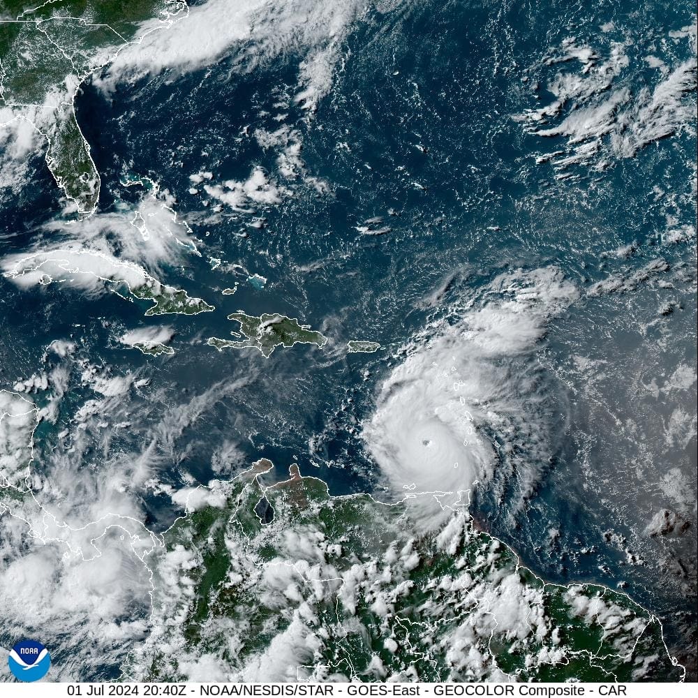
Indeed, the season appeared to ramp up with activity early on with the explosive development of Category 5 Hurricane Beryl in July. Before impacting the United States mainland, the storm devastated areas across the southern Lesser Antilles, including St. Vincent and the Grenadines.
“Hurricane Beryl was the earliest Atlantic basin Category 5 hurricane on record,” NOAA explained. “[After crossing the Lesser Antilles islands, Beryl] caused significant storm surge flooding across parts of Texas and Louisiana after making landfall near Matagorda, Texas, as a Category 1 storm,” NOAA continued.
Two systems developed after Hurricane Beryl—Tropical Storm Chris and Hurricane Debby— before Tropical Storm Ernesto organized and passed across the Virgin Islands on Aug. 13. Ernesto brought strong winds and heavy rain to the islands, knocking out power for several days across portions of the region.
However, a lull in tropical development followed shortly after that, and the Atlantic basin was relatively dormant for several weeks in August and September. After Ernesto, the next system to develop and make landfall occurred on Sept. 11, when Hurricane Francine struck Louisiana as a Category 2 hurricane.
“The impactful and deadly 2024 hurricane season started off intensely, then relaxed a bit before roaring back,” said Matthew Rosencrans, lead hurricane forecaster at NOAA’s Climate Prediction Center, a division of NOAA’s National Weather Service (NWS). “Several possible factors contributed to the peak season lull in the Atlantic region. The particularly intense winds and rains over Western Africa created an environment that was less hospitable for storm development.”
Additional Broken Records Through the Season
The NOAA update went on to share the following information about additional record-breaking cyclones during the season, including Hurricanes Helene and Milton, which severely impacted portions of Florida and areas across the southeastern USA:
“Hurricane Helene made landfall as a Category 4 storm on the Florida Gulf Coast on Sept. 26. The storm caused catastrophic flooding across the southern Appalachians, widespread wind damage from the Gulf Coast to the North Carolina mountains, and storm surge flooding along portions of western Florida. Preliminary data indicate that Helene was the deadliest hurricane to affect the continental U.S. since Katrina in 2005, with more than 150 direct fatalities, the majority of which occurred in North Carolina and South Carolina. Hurricane Helene marked the first time ever that NOAA’s National Hurricane Center (NHC) forecasted a system to become a major hurricane before it became a tropical depression or tropical storm.
Hurricane Milton made landfall as a Category 3 near Siesta Key, Florida, on Oct. 9 and resulted in a tornado outbreak that produced 46 tornadoes and caused torrential rainfall and localized flooding with total rainfall amounts of 10-15 inches (and higher). Milton produced a destructive storm surge between Siesta Key, Florida, and Ft. Myers Beach, Florida, including Charlotte Harbor. Milton’s rate of rapid intensification was among the highest ever observed, with a 90-mile-per-hour increase in wind speed during the 24-hour period from early Oct. 6 to early Oct. 7.”
Lessons Learned
The Source asked Matt Rosencrans to share additional details about this year’s season, including lessons learned through the season. As NOAA’s publication revealed, the amount of tropical development was aligned with meteorologists’ expectations for the season. Still, Rosencrans noted the importance of accounting for the unpredictability that can occur with weather events.
“The observed activity fell within NOAA’s predicted ranges [released] in May and the [subsequent] update in August,” Rosencrans said. “The variable and meandering nature of the activity during the season highlights some of the uncertainties we can research and learn from for future forecasts,” he added.
“[The timing of the tropical development this hurricane season] means [that it is necessary to] prepare for the entire season, anticipating peaks and valleys in activity,” Rosencrans advised. “Keep [your emergency] supplies and plans ready even if there is a lull [in activity],” he continued.
“The predictions [that are created by forecasters] for [hurricane] seasons are [intended to be utilized] for the entirety of the season, which fell within NOAA’s predicted ranges,” Rosencrans noted. “We have [current forecast] products that predict [weather] two to three weeks [into the future,] and [forecasters] are working on products that [ultimately may be able to] predict years [such as] 2024, with distinct peaks and valleys [after more research is done].”
Adding to his comments about forecast models, Rosencrans described specific areas that meteorologists will continue to research with the goal of developing more accurate tools to predict weather.
“We will be looking into the causes of the lull in early September and [will] devise methods to predict such conditions [in the future],” Rosencrans stated. “We are also looking at making outlooks that cover sub-regions of the Atlantic, as well as different sub-periods of time during the season,” he said.
Looking Ahead
Rosencrans provided an update about the possibility of the Virgin Islands receiving additional tropical development through the end of the year and during the off-season.
“[Forecasters] are not expecting/anticipating any more tropical storm development this calendar year,” Rosencrans declared. “[While] sea surface temperatures [SSTs] are warmer than normal, and they are still warmer than the minimum necessary for tropical storm development, the wind shear is too high for tropical development,” Rosencrans noted. “Wind shear should continue to increase while SSTs decrease with each passing day.”
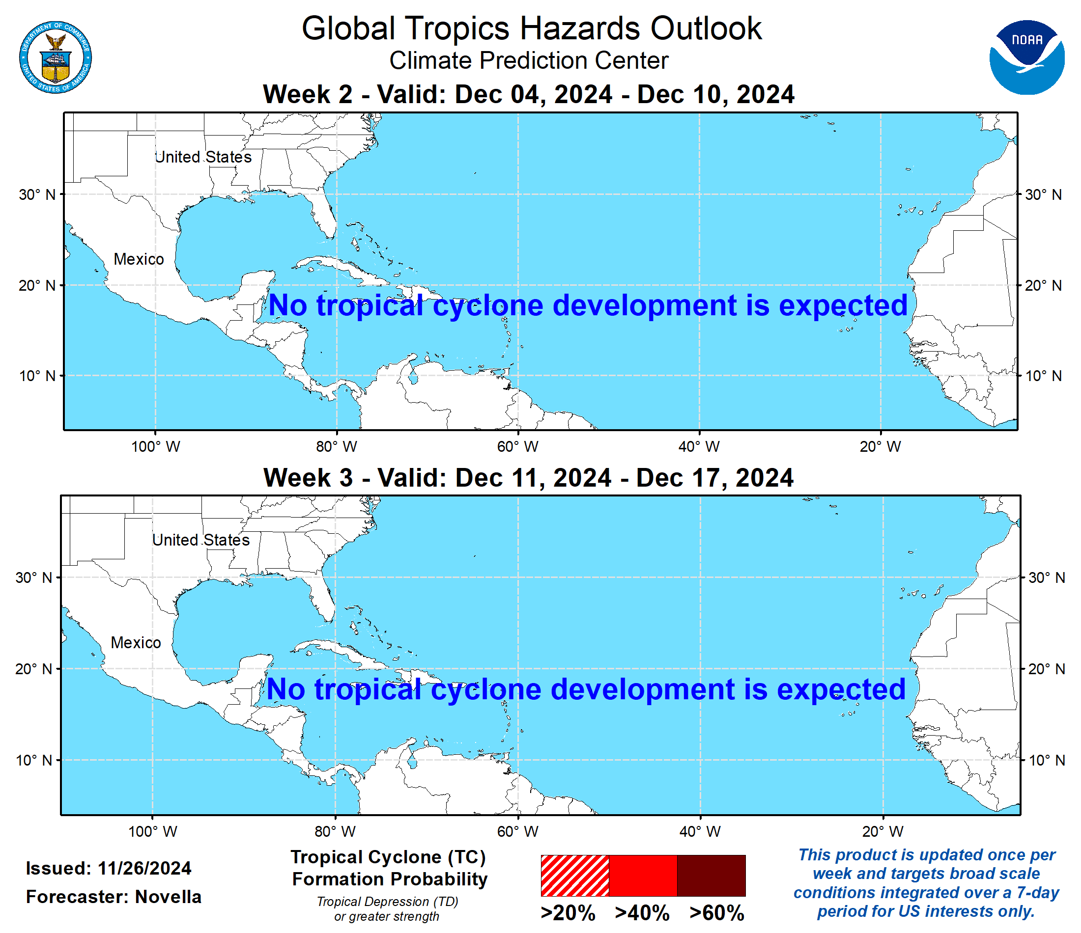
As of Saturday, the final day of this year’s hurricane season, the NHC does not anticipate any cyclonic development over the next seven days. Furthermore, the CPC’s Global Tropics Hazards Outlook does not expect development through the first two weeks of December.
Regardless, V.I. visitors and residents are encouraged to stay up to date with forecasts from the NHC. Hurricane preparedness tips are available from the Virgin Islands Territorial Emergency Management Agency (VITEMA) andNOAA.
Weather forecast information, including severe weather alerts, is available from the VITEMA website and the National Weather Service.
Additionally, the Source Weather Page publishes a daily weather forecast and offers readers the opportunity to view weather forecast videos and disaster preparedness video segments.


