
About 10 years ago, the federal government started using something called the “social vulnerability index” as a guide for allocating resources when an area was hit by a natural disaster, such as a tornado or an outbreak of disease. The idea was to identify the sections of a county where the most at-risk people resided because when disaster struck, they would be most in need of help. More recently, some experts have turned to the index for guidance for non-disaster-related health aid.
The concept was developed by the Centers for Disease Control and Prevention’s Agency for Toxic and Disease Registry and is used as a reference by the Federal Emergency Management Agency.
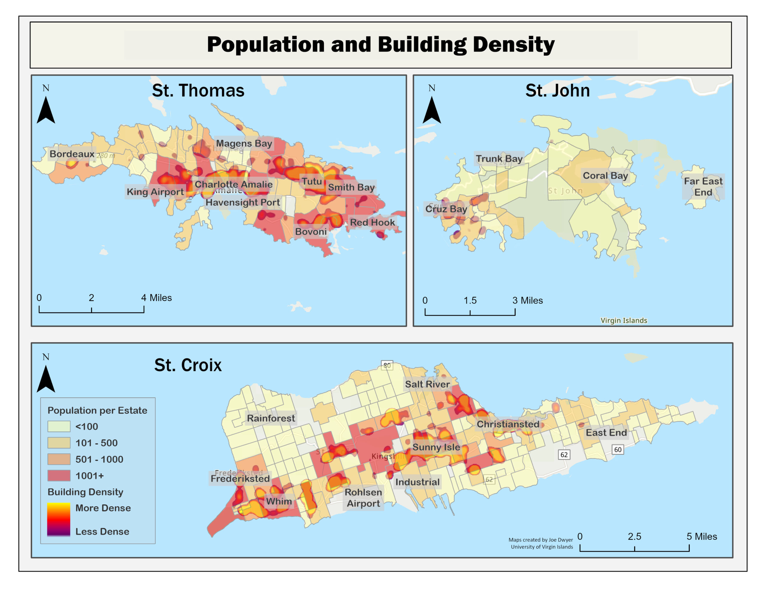
Because the index uses counties as the geographic areas, it has not been used in the Virgin Islands, which doesn’t have counties.
However, it does have estates.
And three local researchers have now published a report attempting to outline sections of the islands per estate that have large pockets of socially vulnerable individuals. There are 335 estates throughout the territory, 85 of which are uninhabited. The report focuses on the remaining 270 estates.
“The Public Health Implications of Social Vulnerability in the U.S.V.I.” was produced by Gregory Guannel, University of the Virgin Islands; Hilary Lohmann, the V.I. Department of Planning and Natural Resources; and Joe Dwyer, UVI.
They plan to introduce and explain the report in a webinar on Oct. 26, Guannel told the Source.
The research was conducted under a grant of about $50,000 from the Natural Hazards Center at the University of Colorado, Boulder, Guannel said.
In explaining its purpose, the report states, “Despite the threat natural hazards pose to the USVI, no national database or report has been developed to measure the social vulnerability of people living in the islands” — mainly because of the absence of counties. As a result, the USVI lacks an understanding of the geographic spread and variation in social vulnerability across its communities. It also has a limited understanding of the location of the most vulnerable populations and the causes of this vulnerability.
“Consequently, emergency management and other organizations are developing disaster preparedness or mitigation strategies without a full understanding of population needs and vulnerabilities. In addition, efforts by these agencies to inform the population about emergency preparedness or household mitigation strategies might not reach all groups that would benefit from such messages,” the report states.
Measuring social vulnerability
The degree of social vulnerability is determined by numerous factors, according to the CDC protocol. Those include poverty, race, the accessibility of transportation, housing and education. But, Guannel said the CDC does not assign specific values to each category and does not provide a total score against which to make evaluations. Moreover, the categories can be subjective because conditions vary from locale to locale.
So the V.I. researchers did not determine the total number of persons within the population who are considered “socially vulnerable,” he said. Nevertheless, the report does talk of the proportions of socially vulnerable people in various estates.
Using information from the 2010 U.S. Census and other available statistics, the report cites several reasons for assigning a high instance of social vulnerability in the territory:
- The number of people living in poverty is 22 percent of the total population. The figure is even higher if you consider only families with children, 30 percent.
- Nearly 60 percent of students were testing below math and literacy standards.
- There is limited access to fresh foods.
- There are frequent natural disasters.
- People tend to live in clusters.
- Although the V.I. has one of the highest car ownership rates in the nation, that does not necessarily translate to access to reliable transportation since an analysis of vehicle registrations by the research team determined the average age of vehicles is 17 years.
Although the report does not say how many people in the territory should be considered socially vulnerable, it indicates that an overwhelming number of people who live in the territory’s many flood zones are socially vulnerable.
Guannel said the researchers used statistical analysis to determine that information.
According to the report, approximately one-third of the homes in St. John’s flood zones are occupied by socially vulnerable people. The numbers are considerably higher in the larger two islands: 71 percent for St. Croix and 87 percent for St. Thomas. Areas of particular concern are Estate Whim on St. Croix, Cruz Bay on St. John and Bovoni, Smith Bay and Charlotte Amalie on St. Thomas.
There are no real surprises in the report, but Guannel said its value lies in documenting conditions and bringing public awareness.
As the report states, “Results presented in this report are consistent with the authors’ understanding of the socially vulnerable of the U.S.V.I. However, for the first time, the intuitive understanding of many has been quantified and mapped using a rigorous approach.”
In times of disaster, the maps can be used to help determine where to locate shelters and where to offer preparedness education, the researchers say in the report.
“In the wake of a hazardous event,” it says, “socially vulnerable hotspots could be highlighted for (FEMA) assistance grants and establishing Points of Distribution during disaster recovery.” Knowledge of those hotspots could also “inform priority” of areas to check for a loss of water and electrical service.
Beyond disasters, there may be policy applications too. The report suggests, as examples, increasing the quality of housing stock and establishing mix-development areas that support a variety of income-level homes.
One weakness in the report, its authors state, is that it had to rely on data from the 2010 Census since the Virgin Islands has not yet received demographic data from the 2020 Census. Guannel said there are plans to update the report findings once that information is available.
The report is available here.


