

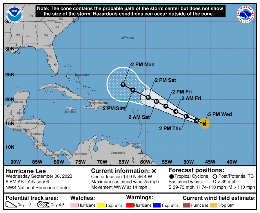
Sept. 6, 5:00 p.m.
As of the 5:00 p.m. update from the National Hurricane Center (NHC) on Wednesday, “Tropical Storm Lee” has intensified and has been upgraded to a category one hurricane.
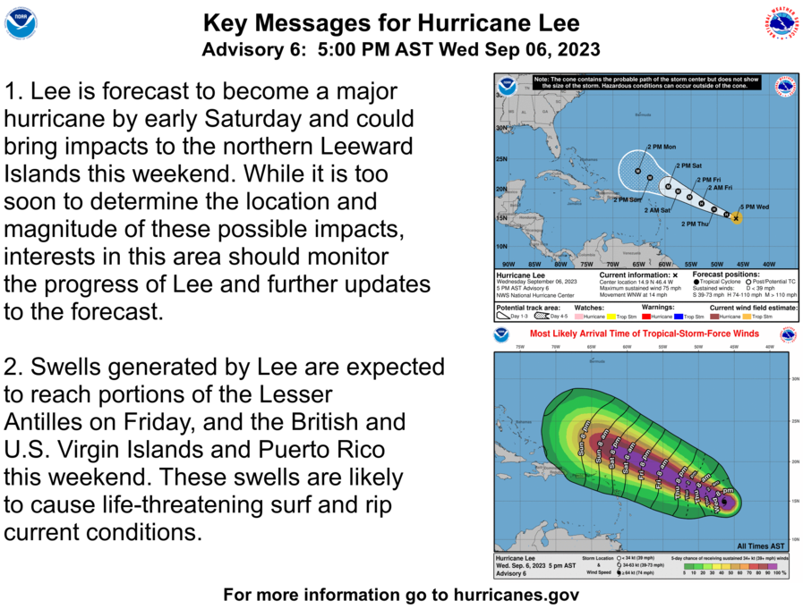
Hurricane Lee is moving toward the west-northwest at approximately 14 mph, and it is now packing maximum sustained winds of approximately 75 mph. The storm is expected to intensify further, potentially into a major category four or five hurricane by the weekend.
The current storm track takes the storm to the north of the USVI and Puerto Rico. However, the exact path remains uncertain, and it is essential to follow this system closely.

Preparing for Cyclone Impacts
On Wednesday, the Source spoke with Virgin Islands Territorial Emergency and Management Agency (VITEMA) director Daryl DeFrance Jaschen. Director Jaschen explained that the agency is prepared for the possibility of impacts from a hurricane, noting that at this time, the primary concern is the possibility of powerful ocean swells up to about 12 feet affecting the northern coastlines of the USVI.
“For this particular storm, we do see that it is probably going to be a maritime concern, especially on the northern coasts of St. Thomas and St. John,” noted Jaschen.
VITEMA has been in contact with the U.S. Coast Guard (USCG) regarding the situation. The USCG set a “Port Condition ‘Whiskey’” on Wednesday, a designation meant to alert operators of ships that gale-force winds are forecast to arrive in the area.
If the hurricane tracks closer to the territory, VITEMA plans to enact additional procedures, including opening emergency shelters for the public.
Staying Informed
Regardless of how close the system is to the USVI and Puerto Rico, impacts may occur, including gusty winds, rain, and choppy seas. Updates will be posted to the Source Weather Page as they become available.
USVI residents and visitors can locate more information about the weather, including locations of emergency shelters and severe weather alerts, from the Virgin Islands Territorial Emergency Management Agency website and the National Weather Service.
A detailed list from the National Weather Service about hurricane preparedness is available here.
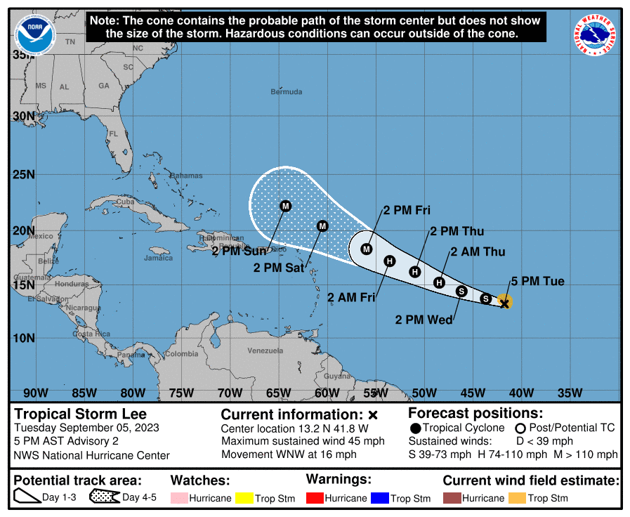
Sept. 5, 5:00 p.m.
A 5:00 p.m. update from the National Hurricane Center (NHC) on Tuesday notes that “Tropical Depression 13” has been upgraded to “Tropical Storm Lee.” The system is moving toward the west-northwest at approximately 16 mph. The cyclone is packing maximum sustained winds of about 45 mph, and it is expected to intensify into a major hurricane by the weekend.
The storm track remains uncertain, and it is important to follow this system closely. Significant forecast changes and updates will be published as they become available.
Sept 5. 1:30 p.m.
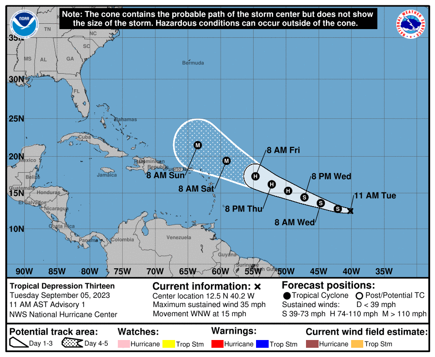
A new tropical depression has formed in the Atlantic and is forecast to intensify into a major hurricane as it moves toward the Caribbean and could impact the U.S. Virgin Islands this weekend.
Tropical Depression 13 is forecast to pass close to the Leeward Islands this weekend. The current storm track is still uncertain, and visitors and residents in the USVI and Puerto Rico should monitor the system closely.
If the system is upgraded to tropical storm strength, it will be named Lee, the 13th named storm of the 2023 Atlantic Hurricane Season, which includes an unnamed system that formed in January.
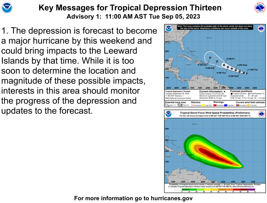
“The depression is forecast to become a major hurricane by this weekend and could bring
impacts to the Leeward Islands by that time,” according to an update from the National Hurricane Center at 11 a.m. on Tuesday.
“While it is too soon to determine the location and magnitude of these possible impacts, interests in this area should monitor the progress of the depression and updates to the forecast,” the update stated.
Tuesday morning’s official forecast from the NHC takes the system just to the north-northeast of the Leeward Islands over the weekend. However, this is not guaranteed, and any small changes in the storm’s track may result in significant weather changes. It is essential to prepare for potential impacts.
It is important to note that the waters surrounding the islands are extremely warm, and the cyclone will enter an environment favorable for possible rapid intensification.
Regardless of how close the system is to the USVI and Puerto Rico, impacts may occur, including gusty winds, rain, and choppy seas. Updates will be posted to the Source Weather Page as they become available.
USVI visitors and residents can find information about severe weather, including emergency shelters and alerts, from the V.I. Territorial Emergency Management Agency and the National Weather Service website. A thorough list from the National Weather Service about hurricane preparedness is available here.


