

The 2024 Atlantic Hurricane Season will officially begin on June 1, and a La Niña weather event may occur during this year’s season. The combination of a La Niña and extremely warm sea surface temperatures may help to increase the number of cyclones that develop in the Atlantic Ocean and Caribbean Sea.
The National Oceanic and Atmospheric Administration’s (NOAA) Climate Prediction Center (CPC), a division of the National Weather Service (NWS), issued a La Niña Watch on Feb. 8, explaining that there is a 55 percent chance of La Niña developing between June and August.
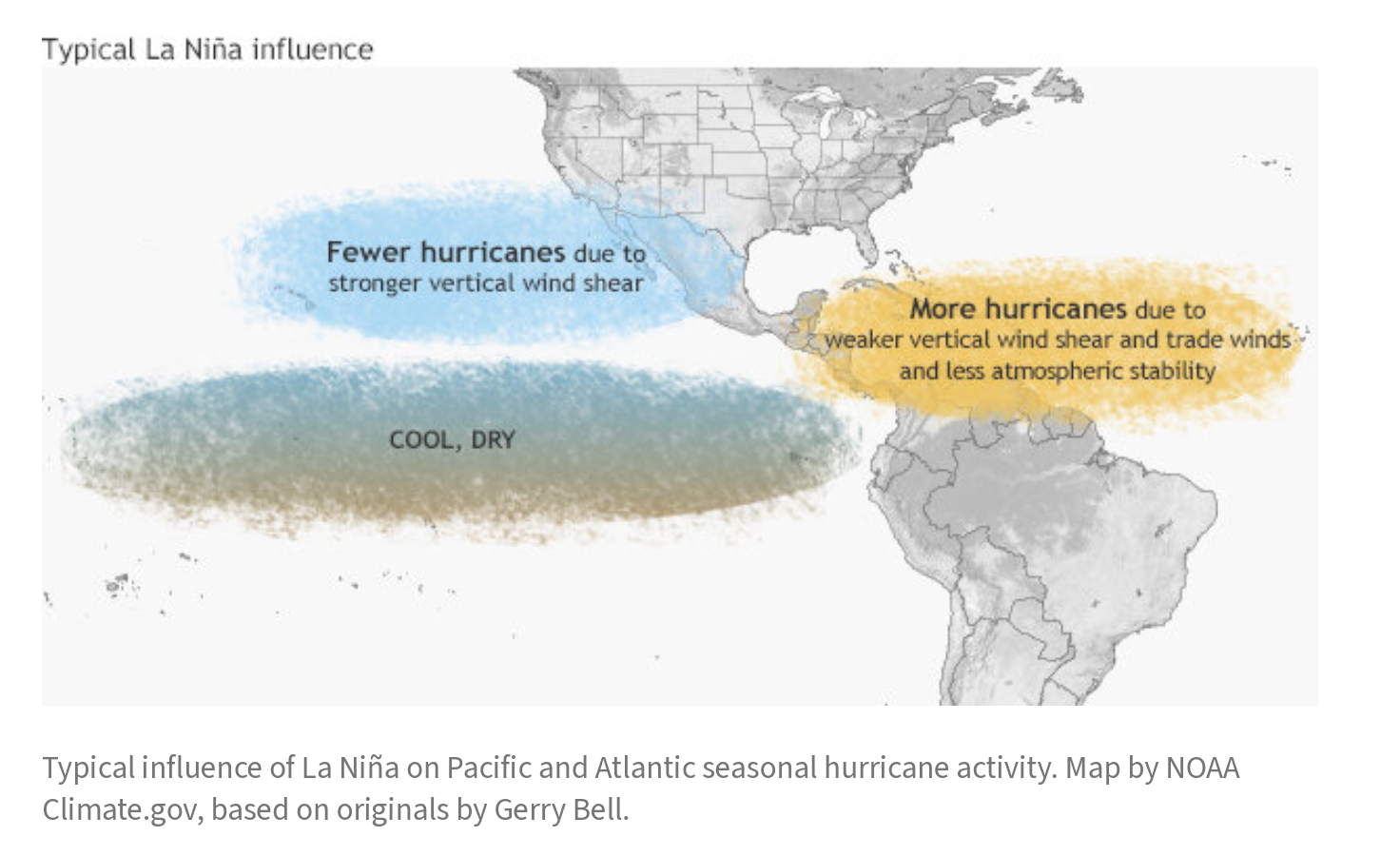
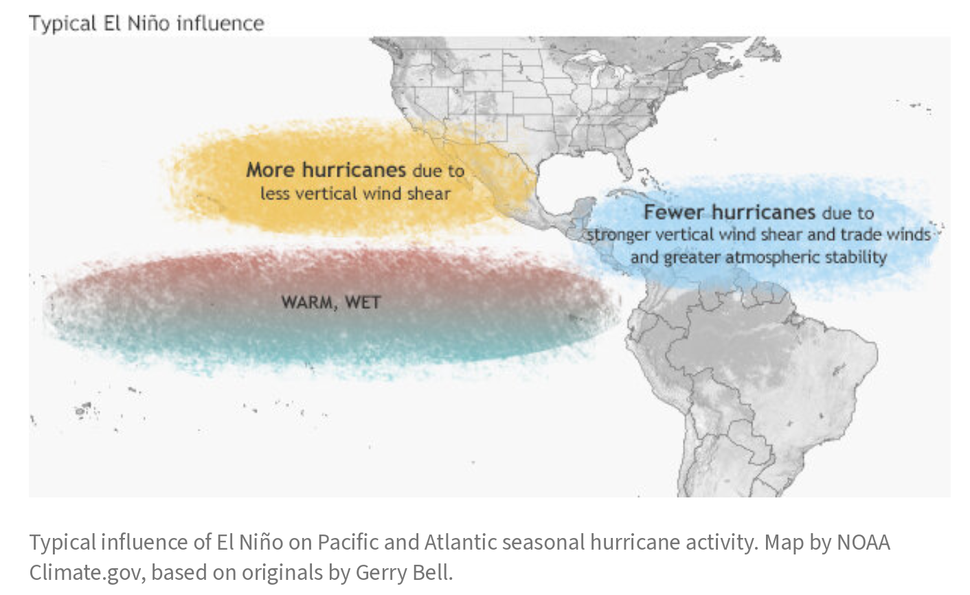
During a La Niña cycle, the waters across the equatorial Pacific Ocean cool significantly, affecting global weather. During La Niña, wind shear — a change in wind direction and velocity with height in the atmosphere — also typically decreases in the Atlantic Ocean. A reduction in wind shear can favor cyclone development. This pattern is the opposite of El Niño, a warming of the equatorial Pacific, which usually increases wind shear in the Atlantic Ocean, helping to rip apart storms and preventing hurricane formation and intensification. A cycle of El Niño has been occurring since June 2023.
“Scientists call [the two opposing climate patterns of El Niño and La Niña] the ‘El Niño-Southern Oscillation’ (ENSO) cycle. El Niño and La Niña can both have global impacts on weather, wildfires, ecosystems, and economies,” according to NOAA.

ENSO Cycle and a Transition to La Niña Further Explained
To learn more about the ENSO cycle and the reasons why a La Niña event this year may increase the number of hurricanes that develop, the Source spoke with Jake Carstens, Ph.D., a postdoctoral scholar in the Department of Meteorology and Atmospheric Science at Pennsylvania State University,
“ENSO is the broader phenomenon that includes both El Niño and La Niña,” Carstens explained. “It is a natural pattern of temperature changes in the tropical central and eastern Pacific Ocean. El Niño is essentially a period with warmer Pacific water, and La Niña is cooler. These fluctuate a bit irregularly, but an individual El Niño and La Niña event occurs every few years on average.”
Carstens provided information regarding NOAA’s recent decision to issue a La Niña Watch and the criteria that must be met for a La Niña to occur.
“The simple answer is that La Niña is favored to develop in the next six months,” Carstens said. “In this case, the CPC gave a 55 percent chance of La Niña conditions developing between June and August.”
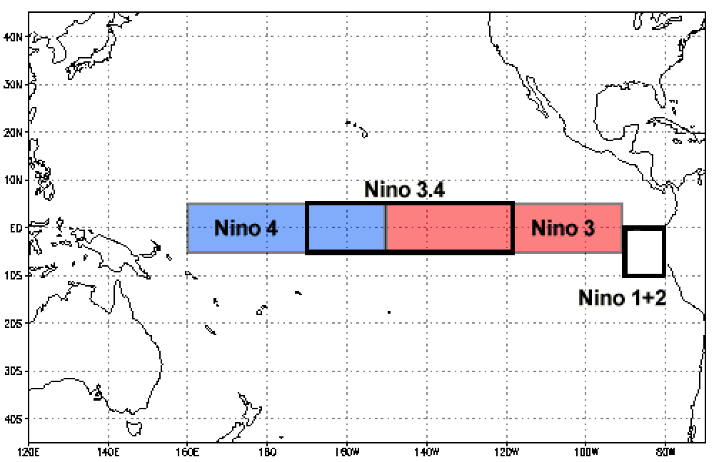
“Specifically, La Niña is considered to be occurring when the sea surface temperature is 0.5°C cooler than average in a specific box of the equatorial Pacific, called the Niño-3.4 region. [The sea surface temperature must remain at least 0.5°C cooler than average] for one month, with the expectation that this will hold for at least three months,” Carstens said. “The CPC has stated it is more likely than not that La Niña will form before or during the peak of Atlantic Hurricane Season,” he noted.
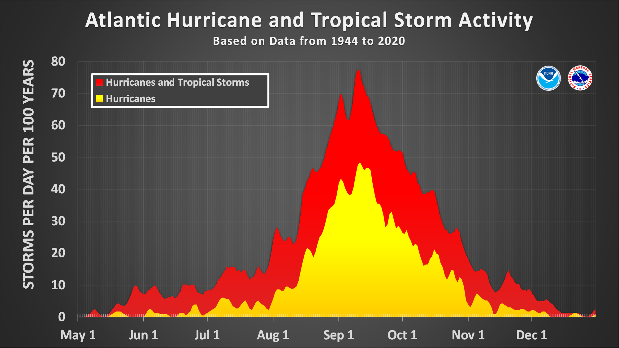
Based on historical records, the peak of hurricane season occurs around the middle of September. The temperatures of the Atlantic Ocean are historically at their warmest during the month of September.
Effects of La Niña and Warm Sea Surface Temperatures on Hurricanes
Carstens described how La Niña affects cyclone development by reducing wind shear in the atmosphere. Wind shear can be detrimental to cyclones. When wind shear is minimal, hurricanes have a better chance of intensifying, provided other optimal atmospheric conditions are in place.
“Every tropical disturbance [develops in a] unique environment, which may or may not favor strengthening,” Carstens explained. However, “on average, La Niña has been found to increase Atlantic hurricane activity by reducing vertical wind shear,” he said.
“The cooling over the Pacific affects upper-atmospheric winds, weakening [the winds] over the Atlantic. This normally allows tropical systems to become more organized and likely to form into tropical storms or hurricanes. While we can’t tell you [exactly when a storm will occur], you’ll probably see plenty of forecasts that call for above-average total storm numbers,” he continued.
Sea Surface Temperatures Fueling Storms
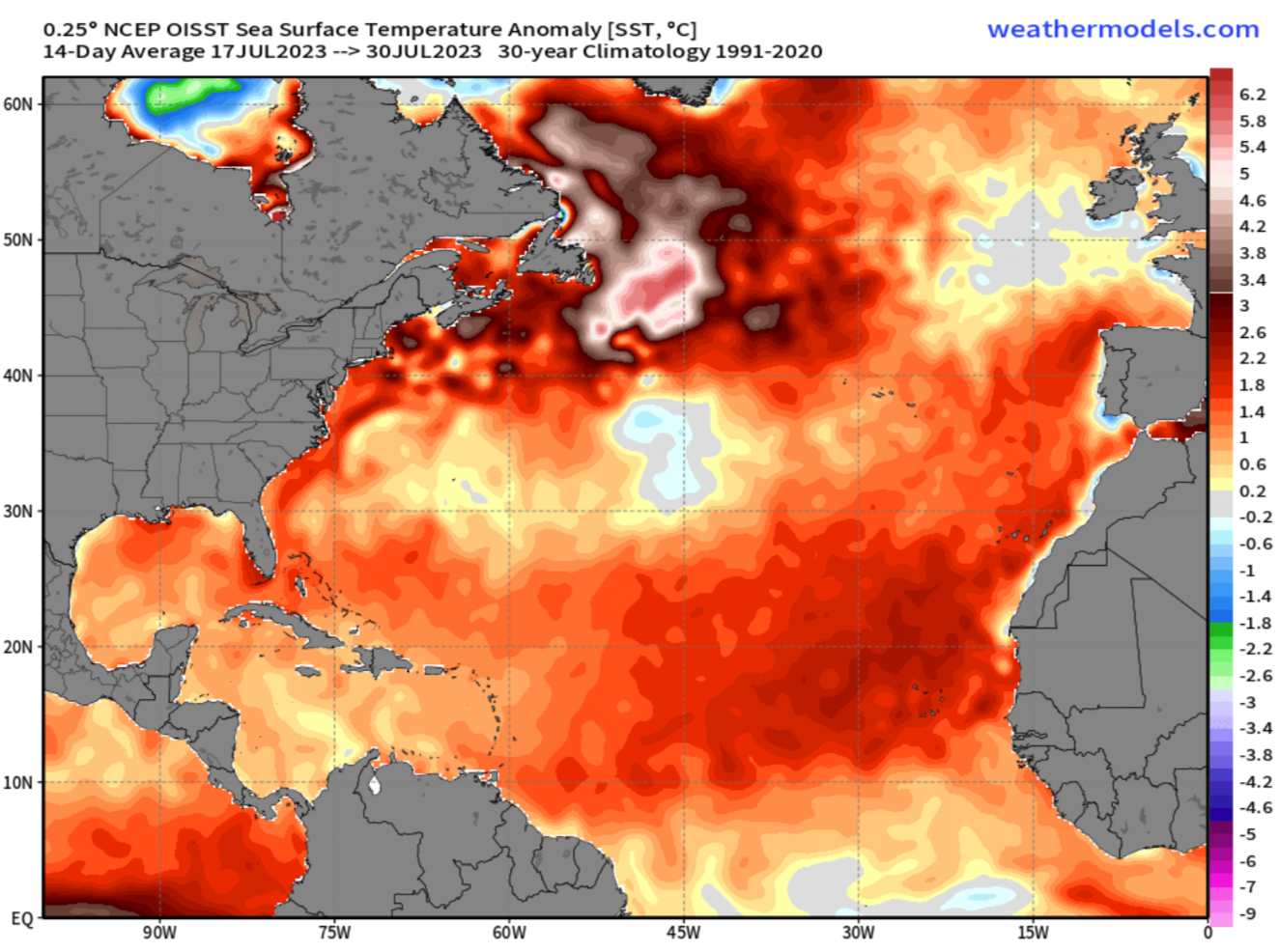
In addition to low wind shear allowing a cyclone to intensify, warm sea surface temperatures further strengthen a storm. As a hurricane passes over warm water, the system can strengthen as it pulls in water vapor and heat, causing evaporation rates to rise. Sea surface temperatures were incredibly warm during 2023, and the warm ocean temperatures are expected to continue during the 2024 season.
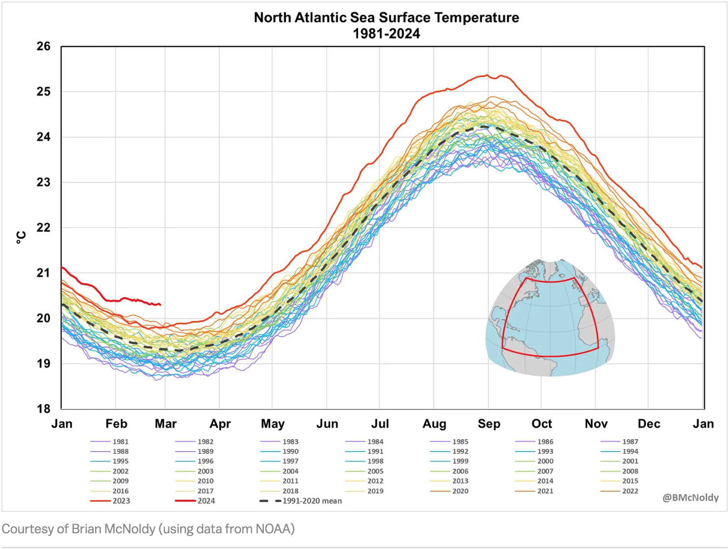
In fact, according to data provided by NOAA, ocean temperatures are already warmer than they were at this time last year. This may prove to be an ominous sign of how warm the waters will be as the year progresses.
“During the first two months of 2024, Atlantic sea surface temperatures have been even warmer [than the first two months of 2023],” Carstens said. “[However,] plenty can change between now and June 1, and there will be ebbs and flows in just how much warmer than normal it is. I do feel that above-average temperatures will stick around, and this can fuel storms quickly if they’re in an otherwise favorable environment with plenty of moisture and weak upper-level winds,” he warned.
With several months until the start of hurricane season, many unknowns exist.
“The exact pattern of how that warmth sets up in the Atlantic will be important, too,” Carstens said. “Will it be mostly at higher latitudes like in some recent years, or will it be concentrated over the Main Development Region [an area located off the coast of Africa and westward across the Atlantic], where many of our strongest storms start? Your guess is as good as mine for now,” Carstens noted.
Whether La Niña develops or not, it just takes one storm to potentially cause catastrophic damage. Given the uncertainty about the upcoming hurricane season — and understanding that weather conditions can always change — Carstens offered the following advice for Virgin Islanders ahead of June.
“Over the next couple of months, review your list of supplies and other parts of your preparation plan in case a hurricane heads your way this summer or fall,” Carstens advised. “There are plenty of resources online, and your local officials can also help you put this together,” he added.
“As we approach June 1, check in with the National Hurricane Center regularly,” Carstens stated. “They’ll start issuing six-hourly outlooks on May 15 to keep an eye on anything that might begin spinning out there,” he concluded.
Stay Informed
USVI residents and visitors can find information about the weather, including severe weather alerts, from the Virgin Islands Territorial Emergency Management Agency website and the National Weather Service.
A daily weather post is also published on the Source Weather Page, where readers can view weather forecast videos.


