

The National Oceanic and Atmospheric Administration has predicted an extremely active 2024 Atlantic Hurricane Season. The number of expected cyclones across the Atlantic basin this year is the highest the agency has ever forecast.
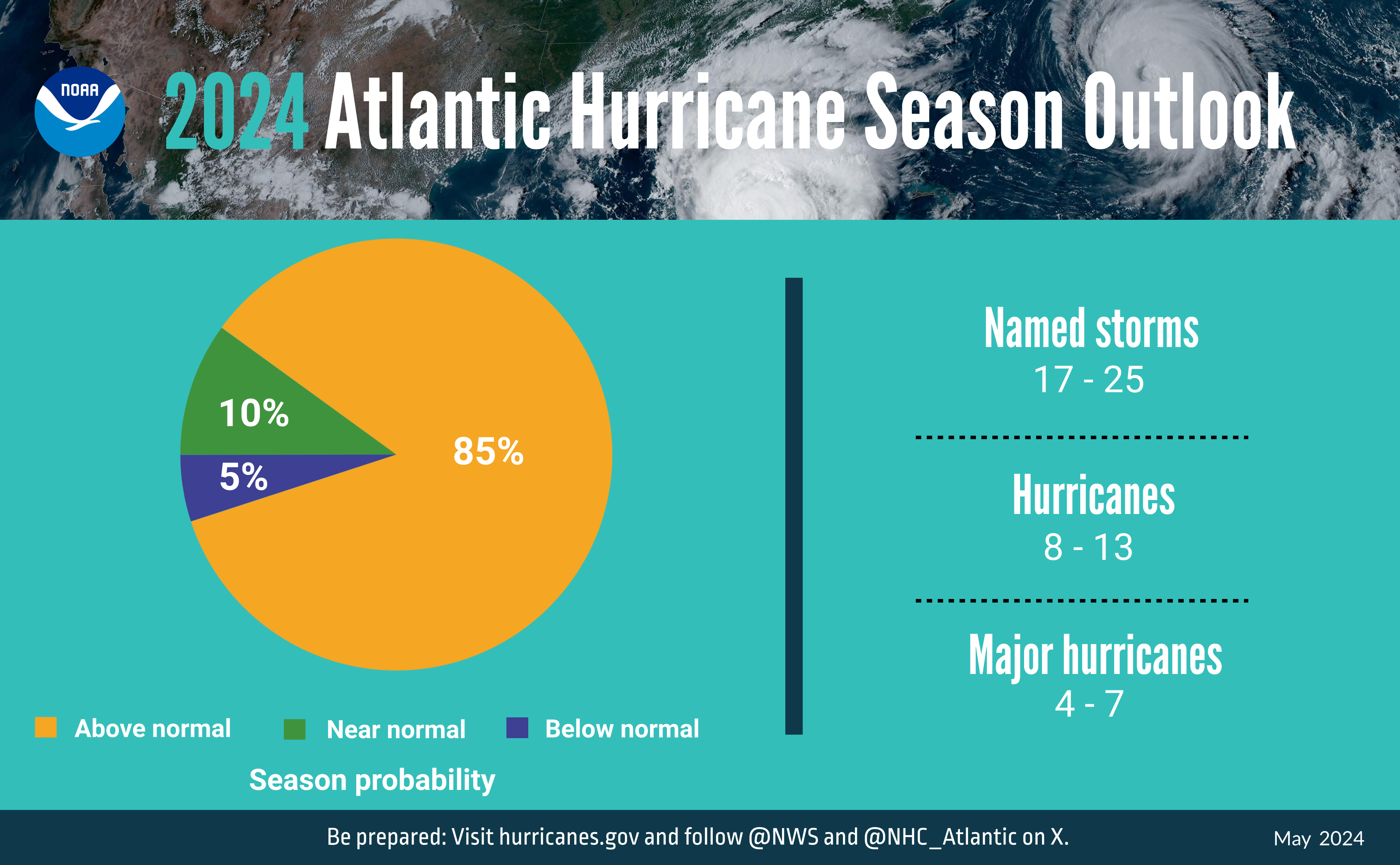
“NOAA’s outlook for the 2024 Atlantic hurricane season, which spans from June 1 to November 30, predicts an 85 percent chance of an above-normal season, a 10 percent chance of a near-normal season, and a 5 percent chance of a below-normal season,” according to information provided from a NOAA press briefing and a press release on Thursday.
“NOAA is forecasting a range of 17 to 25 total named storms (winds of 39 miles per hour or higher),” NOAA said. “Of those [cyclones], 8 to 13 are forecast to become hurricanes (winds of 74 mph or higher), including 4 to 7 major hurricanes (category 3, 4 or 5; with winds of 111 mph or higher). Forecasters have 70 percent confidence in these ranges,” NOAA continued.
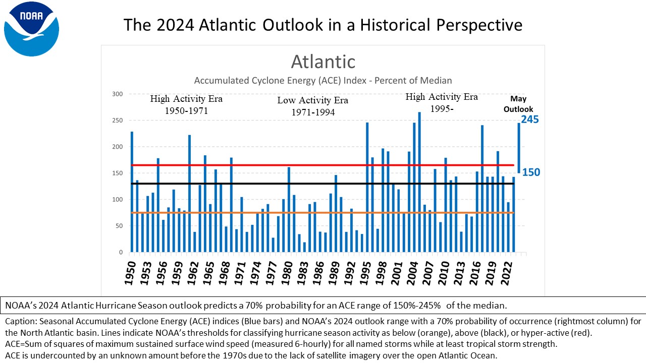
Additionally, NOAA’s Accumulated Cyclone Energy (ACE) forecast is very high, indicating a very active hurricane season.

“ACE reflects the combination of intensity, duration, and numbers of tropical storms and hurricanes,” according to NOAA.
Why 2024 May Be an Extraordinary Hurricane Year
The main reasons for the potentially explosive season are a likely transition from an El Niño weather pattern to La Niña, combined with record-breaking warm sea surface temperatures across the North Atlantic.

“Scientists call [the two opposing climate patterns of El Niño and La Niña] the ‘El Niño-Southern Oscillation’ (ENSO) cycle. El Niño and La Niña can both have global impacts on weather, wildfires, ecosystems, and economies,” according to the NOAA.
As noted in a previous Source article, when a La Niña cycle occurs, the ocean waters across the equatorial Pacific Ocean cool significantly, affecting global weather. During La Niña, wind shear — a change in wind direction and velocity with height in the atmosphere — also typically decreases in the Atlantic Ocean. A reduction in wind shear can favor cyclone development. This pattern is the opposite of El Niño, which causes a warming of the equatorial Pacific, which usually increases wind shear in the Atlantic Ocean. The wind shear helps to tear apart developing storms and prevent hurricane formation and intensification. A neutral phase of ENSO occurs when neither El Niño nor La Niña is happening, often occurring during the transition of an El Niño to a La Niña. An ENSO-neutral phase may also result in lower wind shear across the Atlantic, resulting in more favorable conditions for cyclones to develop.
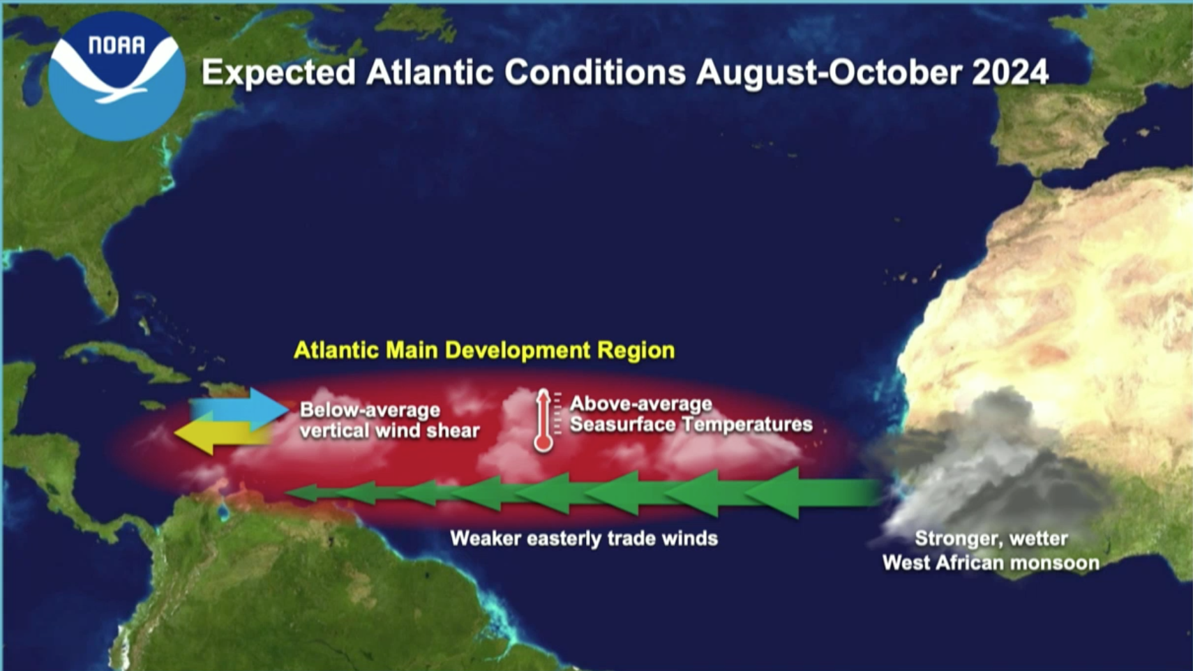
Regarding very warm sea surface temperatures and the effects on hurricanes, the National Weather Service (NWS) notes that warm ocean water adds fuel to a cyclone through a process of evaporation and condensation, allowing a tropical disturbance to intensify. Low wind shear combined with plentiful moisture across the ocean due to warmer sea temperatures increases the likelihood of cyclone intensification.
Additionally, NOAA said that tropical disturbances exiting the west coast of Africa may occur more frequently this year due to the West African Monsoon.
“This hurricane season also features the potential for an above-normal West African Monsoon, which can produce African easterly waves that seed some of the strongest and longer-lived Atlantic storms,” NOAA explained.
Climate change was also referenced as a reason hurricanes may become more dangerous.
“Human-caused climate change is warming our ocean globally and in the Atlantic basin, and melting ice on land, leading to sea level rise, which increases the risk of storm surge [and flooding]. Sea level rise represents a clear human influence on the damage potential from a given hurricane,” NOAA warned.
Monitoring the Tropics
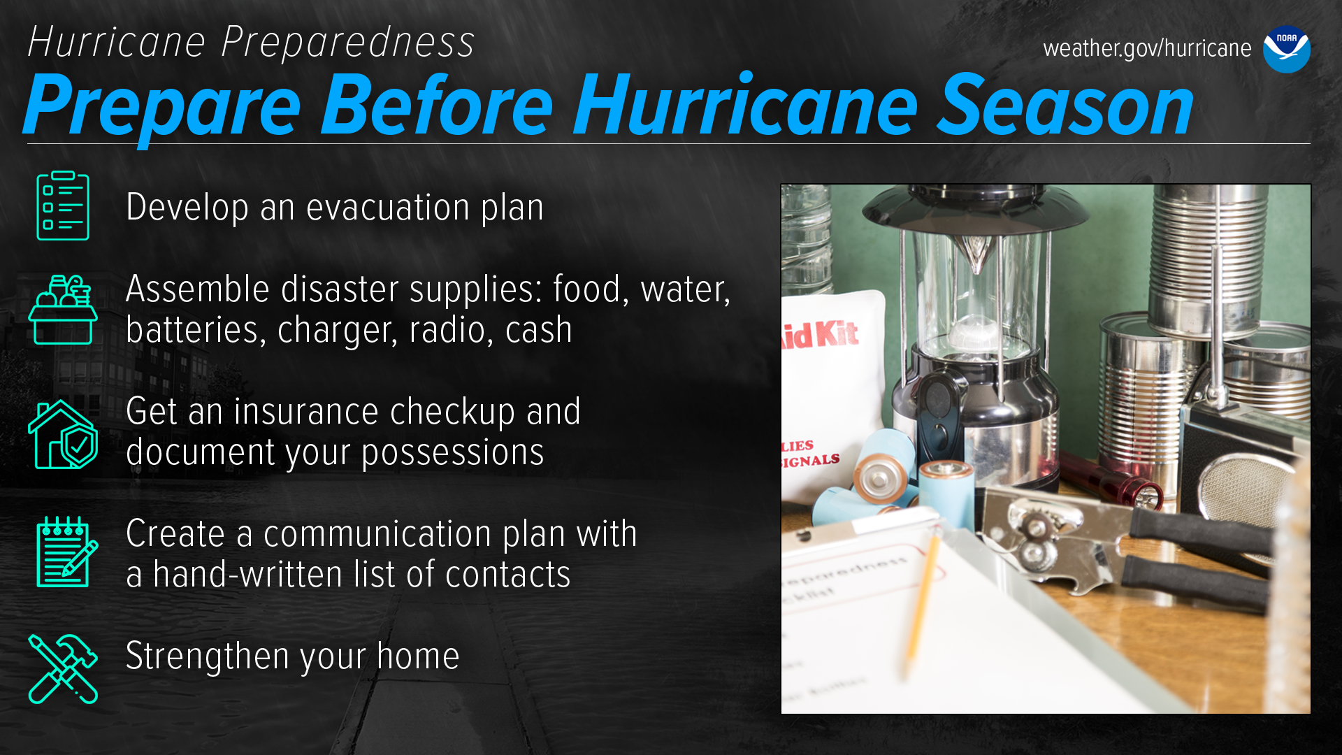
Experts are particularly concerned about the rapid intensification of cyclones this year, and residents of coastal locations by the Atlantic Ocean, the Gulf of Mexico, and the Caribbean Sea are advised to start hurricane season preparations before any storms are on the horizon.
“Many large coastal cities require 48 to 72 hours to announce mandatory evacuations, organize shuttles, and activate highway contraflow for evacuation traffic,” according to information provided by AccuWeather. “State and local leaders are being urged to prepare for tropical threats that could quickly escalate into major storms this hurricane season,” AccuWeather explained.
In its press release, NOAA shared news regarding new tools and upgrades to help more accurately predict cyclones, including helping to forecast rapidly intensifying storms.
“Two new forecast models developed by NOAA researchers will go into operation this season. The Modular Ocean Model, or MOM6, will be added to the Hurricane Analysis and Forecast System to improve the representation of the key role the ocean plays in driving hurricane intensity. Another model, SDCON, will predict the probability of tropical cyclone rapid intensification,” NOAA noted.
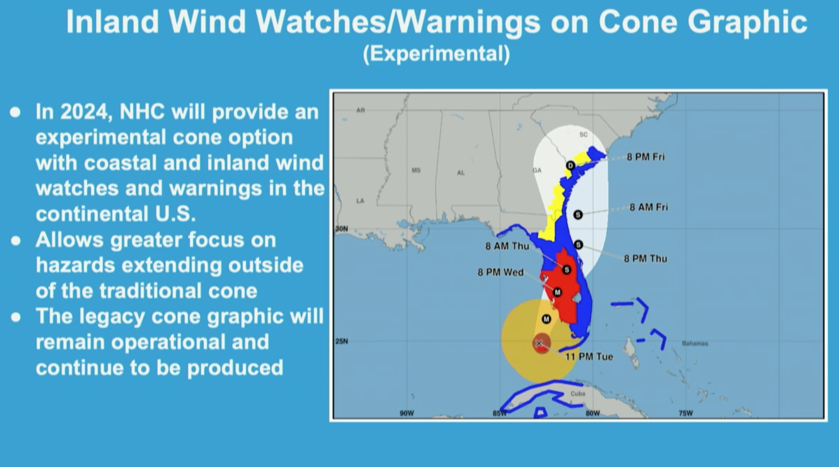
Additionally, starting in August, NOAA will implement changes to forecast graphics to communicate storm-related impacts more effectively.
“Beginning on or around August 15, National Hurricane Center will start to issue an experimental version of the forecast cone graphic that includes a depiction of inland tropical storm and hurricane watches and warnings in effect for the continental U.S. Research indicates that the addition of inland watches and warnings to the cone graphic will help communicate inland hazards during tropical cyclone events without over-complicating the current version of the graphic.”
Hurricane Season Preparations
Even with a large number of storms predicted, it is impossible to forecast where, when, or if a hurricane makes landfall. NOAA advises individuals to be prepared before, during, and after a hurricane.
Matt Rosencrans, NWS lead hurricane seasonal forecaster, shared advice for the U.S. Virgin Islands and Puerto Rico residents ahead of hurricane season.
“I advise everyone to start preparing now,” Rosencrans recommended. “Residents of the USVI and Puerto Rico know that supplies can take time to reach them, so please start early. Often, the recovery on islands can take longer than [the U.S.] mainland areas due to transportation complications, so take the time now to have more supplies,” he continued.
Rosencrans also provided resources that individuals may find helpful for hurricane preparations.
“Ready.gov and listo.gov are great resources,” Rosencrans said. “NOAA also has step-by-step instructions, and the Virgin Islands Territorial Emergency Management Agency (VITEMA) may also have the necessary information that’s localized to the islands and island residents’ unique needs.”
USVI Weather Information
In addition to weather information from the NWS and VITEMA, a daily weather forecast is also published on the Source Weather Page, where readers can view weather forecast videos and disaster preparedness video segments.


