


The Federal Emergency Management Agency (FEMA) designates the month of September as National Preparedness Month to encourage individuals to be prepared for emergencies. FEMA has provided preparedness tips for individuals across the U.S. Virgin Islands as the peak of hurricane season arrives, bringing the potential for more cyclonic development.
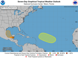
As of Friday, the National Hurricane Center is monitoring two areas for possible cyclonic development over the next seven days. The areas under investigation have between a low and medium chance of experiencing development. While there are no cyclones in the forecast for the USVI, a tropical wave is forecast to pass near the region on Sunday, raising the risk of rain and thunderstorms across the local islands.
“To raise awareness about the importance of preparedness, FEMA and the USVI will join the nation in observing National Preparedness Month this September,” according to a press release from the U.S. Virgin Islands Caribbean Area FEMA Office.
“This annual campaign encourages individuals, families, businesses, and communities to take proactive steps to ensure their readiness in the event of emergencies or natural disasters,” the FEMA statement said. “Start a conversation today and take simple steps to strengthen your preparedness for the peak of hurricane season.”
FEMA Virgin Islands Caribbean Area Office NR-26 Acting Coordinator Aaron VanDoren explained how the recent experience of Tropical Storm Ernesto passing across the Virgin Islands can help residents and visitors across the USVI prepare for any possible future storms this season.
“Tropical Storm Ernesto’s path over the U.S. Virgin Islands earlier this month was a wake-up call for Virgin Islanders to assess how self-sufficient they might be in the immediate days after a storm makes landfall,” according to a statement from VanDoren included with the FEMA press release.
Communication is Key to Preparing for Emergencies
This year’s preparedness month theme is “Start a Conversation.” FEMA encourages individuals to communicate about how to prepare for disasters.
“National Preparedness Month provides an excellent opportunity for families and businesses to practice their emergency plans. Take steps today to replenish emergency supplies used during Ernesto and ask friends and neighbors if they need help with their preparedness plans,” VanDoren’s statement explained.
FEMA and the Virgin Islands Territorial Emergency Management Agency (VITEMA) offered the following advice to stay as prepared as possible throughout hurricane season.
- Create an emergency supply kit with essential items such as non-perishable food, water, prescription medications, flashlights, batteries, and a first-aid kit.
- Develop a family emergency plan that includes communication methods, evacuation routes, and a designated meeting point.
- Stay informed by monitoring local weather forecasts, emergency alerts, and official announcements.
- Secure important documents and make digital copies of vital records.
- Protect your property by securing loose objects, trimming trees, and reinforcing doors and windows.
- Plan for an extended power outage. Make an inventory of the items you need that rely on electricity. Plan for batteries and other alternative power sources to meet your needs when the power goes out.
- Sign up for Alert VI online.
Tropics are Relatively Quiet—For Now
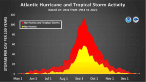
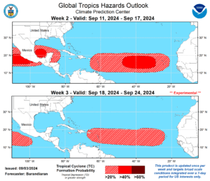
Climatologically speaking, the peak of the 2024 Atlantic Hurricane Season is upon us. However, tropical development across the Atlantic has been unusually quiet recently.
An article from Fox Weather provided insight into the current lull in cyclonic development.
“Dr. Phil Klotzbach, a hurricane specialist at Colorado State University, said he expects tropical cyclone activity in the basin to be at normal or below-normal levels through at least Sept. 16,” according to the Fox News article.
“The chance of above-normal activity during the next few weeks is just 10% as the basin remains in a state of record inactivity,” the article explained. “In fact, the lack of tropical activity from Aug. 12 through Sept. 3 marked the quietest period in tropical weather development in 56 years, with the basin now starting to fall behind key metrics for an average season,” the article continued.
“There are at least four different elements forecasters are highlighting that are weighing down activity: the location of the monsoon trough over Africa, cooling waters in the eastern Atlantic, significantly warm temperatures in the upper levels of the atmosphere and abundant dry air around the eastern edge of the basin,” Fox Weather said.
Jake Carstens, a tropical meteorologist and Assistant Professor in the Department of Atmospheric Sciences at the University of North Dakota, provided the Source with additional details about the weather conditions affecting tropical activity.
“What has been noteworthy recently is how active the African Monsoon [has been],” Carstens said. “Strong onshore winds into Africa have transported moisture as far north as the Sahara Desert, bringing heavy rain to places that don’t often see it,” he explained. “This is potentially linked to a northward shift of the African Easterly Jet, a jet stream that forms many of the waves that eventually become hurricanes,” he continued.
Tropical Development Remains Possible Through Second Half of Hurricane Season
A lack of storm development certainly comes as good news. Still, several notable systems have occurred this year, including Tropical Storm Ernesto’s trek across the U.S. Virgin Islands in August. Additionally, this season has already been record-breaking, particularly due to destructive Hurricane Beryl, which rapidly intensified into a major hurricane and devastatingly impacted portions of the Caribbean in July.
Carstens anticipates seeing more tropical development as the season progresses.
“It’s nice to see the season being unexpectedly quiet these last few weeks,” Carstens stated. “With that said, I still expect a relatively busy second half [of hurricane season],” he said.
“As we move toward October, the focus [for tropical development] tends to shift back toward areas like the Caribbean and [the] Gulf of Mexico, which are not inhibited by the factors limiting development out [in the Eastern Atlantic],” Carstens explained. “It’s certainly possible that future waves moving through the area struggle to form into anything impactful, and we’ll be rooting for that,” he added.
VI Source Daily Weather Updates
With over two and half months remaining until the end of hurricane season on November 30, individuals across the region are encouraged to remain vigilant.
Additional information regarding hurricane preparedness is available online from VITEMA and the National Weather Service.
The Source Weather Page also publishes a daily weather forecast and offers readers the chance to view weather forecast videos and disaster preparedness video segments.


