

On March 20, the U.S. Virgin Islands will participate in an annual tsunami preparedness drill aimed at educating residents and visitors about the dangers of tsunami waves and the steps to take to stay safe.
“Caribe Wave is the annual tsunami exercise of the Intergovernmental Coordination Group for the Tsunami and Other Coastal Hazards Warning System for the Caribbean and Adjacent Regions of the Oceanographic Commission of the United Nations Educational, Scientific, and Cultural Organization (UNESCO),” according to TsunamiZone.com.
Approximately 48 countries and territories are a part of the UNESCO Caribe Early Warning System, including the Virgin Islands and Puerto Rico.
“The purpose of this exercise is to validate and advance tsunami preparedness efforts in the Caribbean and Adjacent Regions, [and] the annual Tsunami Regional Exercise, ‘Caribe Wave 2025,’ will take place on March 20, starting at [11 a.m. Atlantic Standard Time],” TsunamiZone said.

What Will Occur During the Caribe Wave Exercise?
This year, the Caribe Wave exercise will simulate two separate hypothetical scenarios that could generate tsunami waves across the Caribbean region. One event will be focused on an earthquake centered near Jamaica, and the other situation will highlight a theoretical quake that strikes near Portugal.
“Two different scenarios will be simulated for Caribe Wave 2025, [and] each participating country [or territory] will select the scenario that best fits their objectives,” TsunamiZone explained. “The first scenario simulates a tsunami generated by a magnitude 8.0 earthquake located along the Enriquillo-Plantain Garden Fault Zone [near Jamaica], and the second scenario [involves] a tsunami generated by a magnitude 8.5 earthquake located approximately 270 kilometers off the Portugal coast,” TsunamiZone continued.

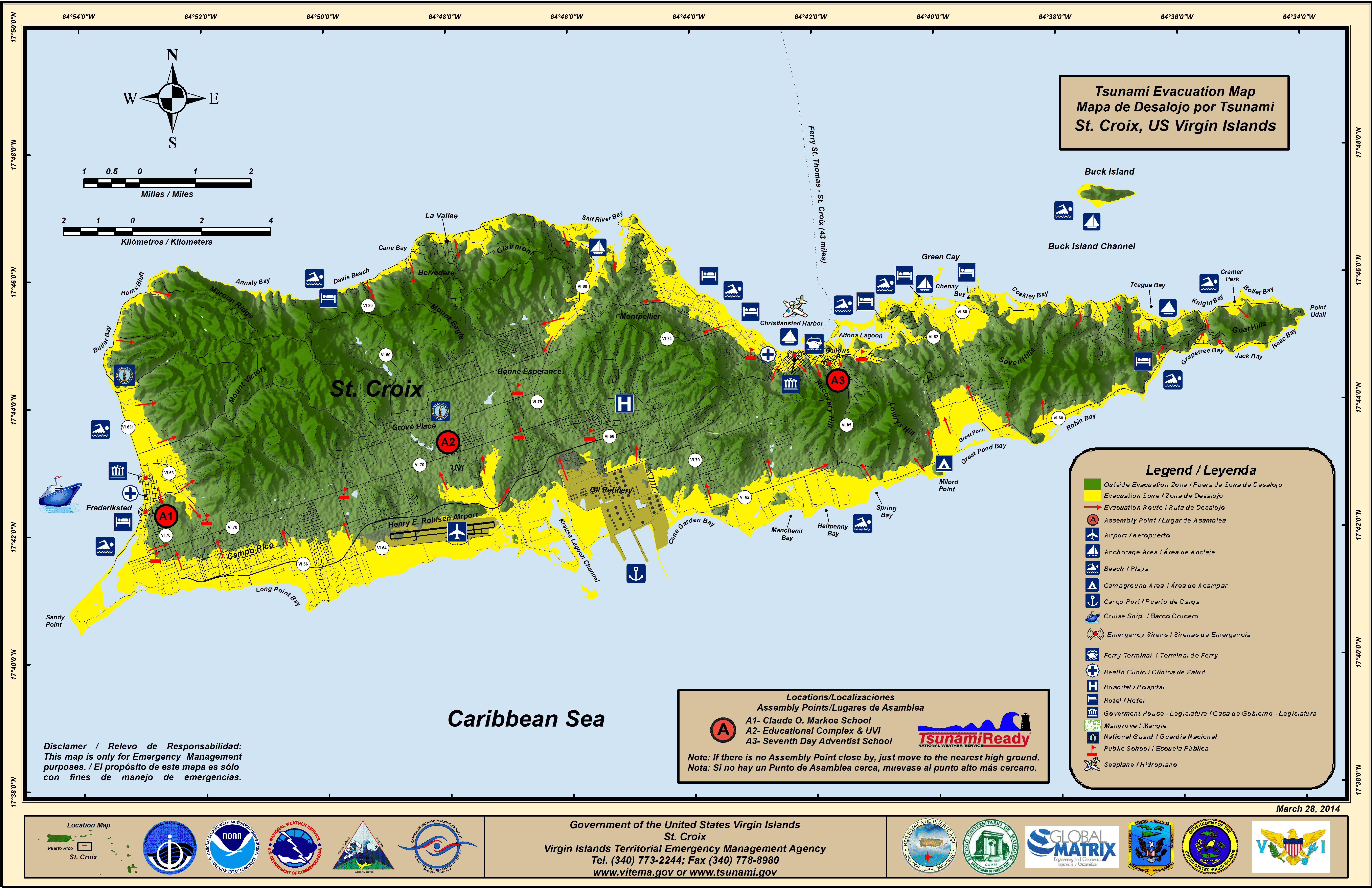
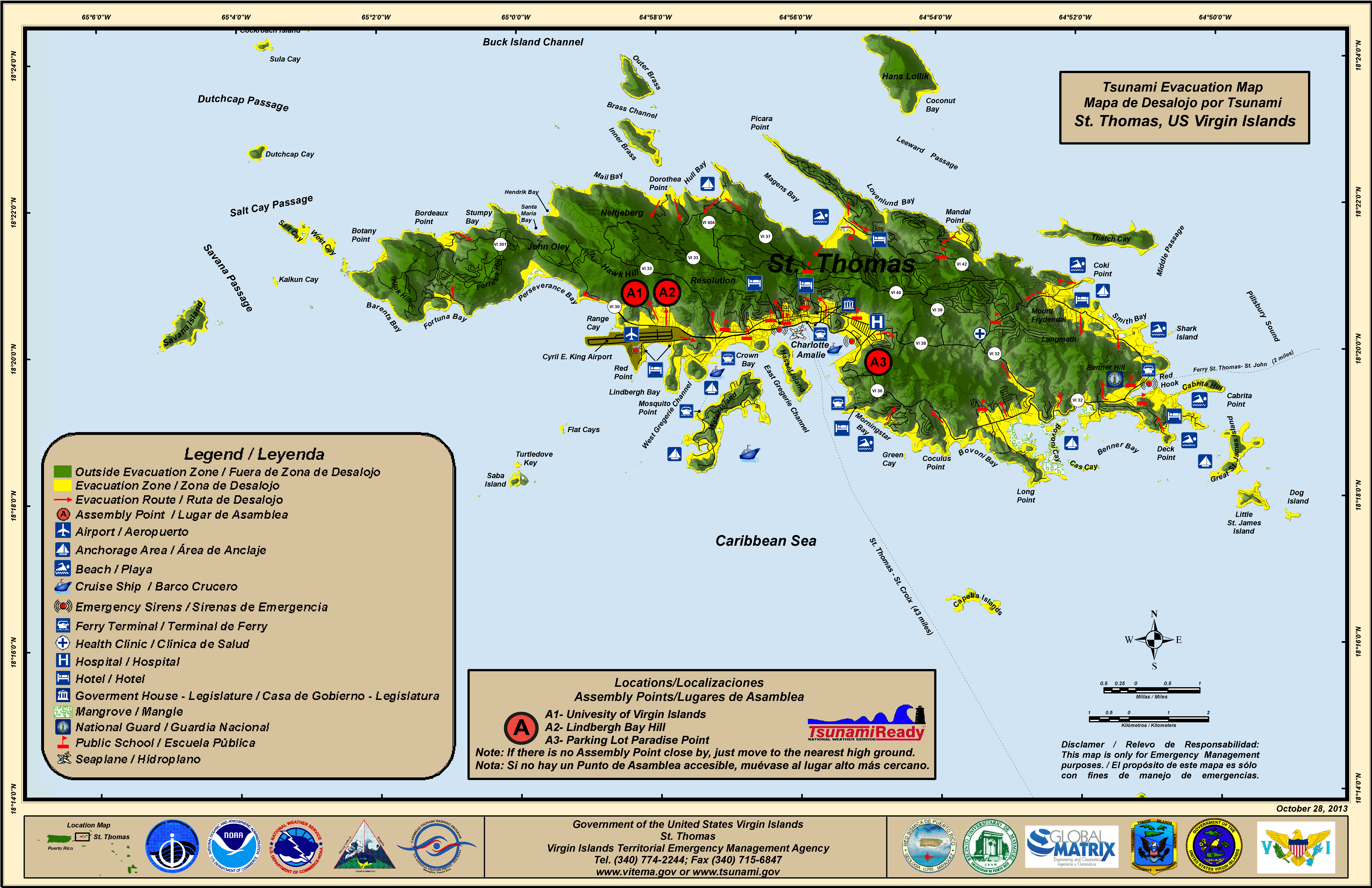
According to information about the exercise, the Virgin Islands will participate in the “Portugal Scenario,” which could generate tsunami waves between one and three meters (three to nine feet) across Caribbean islands.
“The [Portugal Scenario] exercise is based on a hypothetical tsunami scenario similar to ‘The Great Lisbon Earthquake’ that occurred on November 1, 1755,” according to information from UNESCO. “During [that] event, a major earthquake [estimated at having a magnitude between 8.6 and 9.0 occurred] in Lisbon, Portugal, [and] generated a transoceanic tsunami that reached the European and African coasts, islands in the Atlantic, and the Caribbean islands,” UNESCO stated.
“Tsunami messages for this exercise [will be] issued by the Pacific Tsunami Warning Center (PTWC) and the Central American Tsunami Advisory Center based on hypothetical tsunamis,” according to information from UNESCO. “Expected impacts for these events are determined from pre-computed tsunami forecast models,” UNESCO said.
The Source spoke with Daryl Jaschen, director of the Virgin Islands Territorial Emergency Management Agency(VITEMA), regarding communicating the emergency messages that are planned to be issued. Jaschen explained that VITEMA will receive the simulated alert notifications from the PTWC, and the agency is currently planning how to share the messages with the public. Jaschen said that mock radio broadcasts may be utilized to help convey instructions for what the public should do to stay safe.
Jaschen noted that VITEMA plans to utilize the Caribe Wave to enhance preparedness for earthquakes and tsunamis, including conducting evacuation drills at schools across the territory. (The location of the school(s) has yet to be determined as of the writing of this article.)
Jaschen also said that regularly scheduled tests of the Territory-Wide Emergency Alert System will occur, and sirens will be activated on the same day as the Caribe Wave exercise. To receive notifications issued by VITEMA, individuals can sign up for AlertVI on the agency’s website. Residents can also register for the Caribe Wave event at TsunamiZone.comto help them be ready for an actual emergency.
Preparing for Earthquakes and Tsunamis
The Caribe Wave simulation comes on the heels of a powerful temblor that occurred near Honduras on February 8, 2025, when a Tsunami Advisory was briefly issued for areas including the Virgin Islands.
The recent tsunami advisory further exemplifies the importance of preparing for earthquakes and tsunamis across the region.
A previous Source article shared information about the threats to both U.S. territories caused by earthquakes and tsunamis, noting that the islands are positioned in an active seismic zone:

“During an earthquake, it is critical for people to ‘Drop, Cover, and Hold On’ to protect themselves,” said Elizabeth Vanacore, a seismologist and a researcher at the Puerto Rico Seismic Network (PRSN).
“If you are driving your car [during a] small [seismic] event, you might not perceive the earthquake,” she explained. “However, if there is a larger event, recommended actions become situational. For instance, if you are in a safe area without electric poles or trees, then you should come to a stop, pull the handbrake, and protect your head with your arms,” Vanacore cautioned.
Vanacore encouraged the public to get involved in drills and exercises [including Caribe Wave] that are intended to familiarize and prepare residents and visitors across the region in the event of an earthquake or a tsunami.
“Understanding the hazards due to earthquakes and tsunamis in the region is constantly improving thanks to efforts of scientists and emergency managers both in the USVI and Puerto Rico,” Vanacore declared. “Relationships across the islands are critical to our continued resilience, [and] while earthquakes and tsunamis cannot be predicted, we can all prepare for them,” she noted.
Tsunami Notifications and Their Meanings
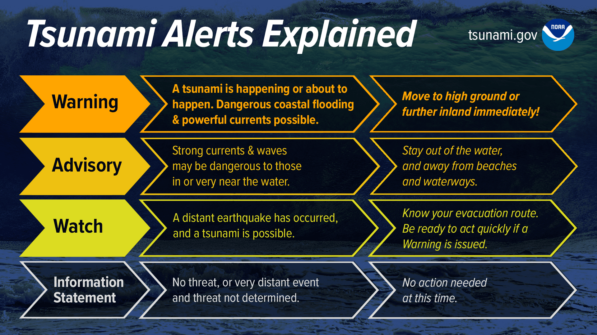
In the event of an actual emergency during which tsunami notifications are issued, the National Weather Service (NWS) offers the following information about tsunami alerts and how to interpret them:
“Tsunami Warning: Take Action—Danger! A tsunami that may cause widespread flooding is expected or occurring. Dangerous coastal flooding and powerful currents are possible and may continue for several hours or days after initial arrival. Follow instructions from local officials. Evacuation is recommended. Move to high ground or inland (away from the water).
“Tsunami Advisory: Take Action—A tsunami with potential for strong currents or waves dangerous to those in or very near the water is expected or occurring. There may be flooding of beach and harbor areas. Stay out of the water and away from beaches and waterways. Follow instructions from local officials.
“Tsunami Watch: Be Prepared—A distant earthquake has occurred. A tsunami is possible. Stay tuned for more information. Be prepared to take action if necessary.
“Tsunami Information Statement: Relax—An earthquake has occurred, but there is no threat, or it was very far away, and the threat has not been determined. In most cases, there is no threat of a destructive tsunami.”
Weather Information
Additionally, Weather information is also updated regularly on the Source Weather Page, the Source YouTube Channel, and on the official website of the National Weather Service in San Juan, Puerto Rico. USVI residents and visitors can also sign up for emergency alerts, including earthquake and tsunami notifications, from VITEMA.


